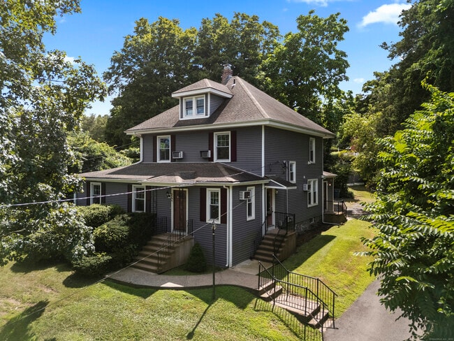
Property Record
2764 Whitney Ave, Hamden, CT 06518
NEARBY LISTINGS FOR SALE OR LEASE
Property Detail
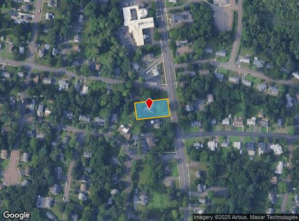
2764 Whitney Ave
New Haven, CT
New Haven
HAMD-002831-000163
Connecticut
Sfr
0.46 AC
X
Hamden
09009C0294K
Westchester/So Connecticut
2,536 SF
DEMOGRAPHICS near 2764 Whitney Ave
1 Mile
3 Mile
5 Mile
2024 Total Population
9,689
47,517
114,044
2029 Population
9,666
47,635
113,869
Pop Growth 2024-2029
(0.24%)
+ 0.25%
(0.15%)
Average Age
41
42
42
2024 Total Households
4,217
18,625
44,617
HH Growth 2024-2029
(0.45%)
+ 0.22%
(0.15%)
Median Household Inc
$86,786
$95,078
$87,237
Avg Household Size
2.10
2.30
2.40
2024 Avg HH Vehicles
2.00
2.00
2.00
Median Home Value
$243,770
$293,446
$286,070
Median Year Built
1982
1970
1965
Nearby Places
Map Layers
Map Styles
 Street
 Aerial
- Restaurants
- Banks
- Shops
- Fitness
- Groceries
PUBLIC TRANSPORTATION
COMMUTER RAIL
New Haven-State Street Station (New Haven Line - Metro-North Commuter Railroad Company (Metro-North))
DRIVE
WALK
Distance
New Haven-State Street Station (New Haven Line - Metro-North Commuter Railroad Company (Metro-North))
12 min
6.9 mi
DRIVE
WALK
Distance
13 min
7.5 mi
AIRPORT
Tweed/New Haven
DRIVE
WALK
Distance
Tweed/New Haven
22 min
11.4 mi
SALE & LEASE HISTORY
LISTING DATE
SALE/LEASE

Sep 24, 2016
For Sale
Oct 25, 2017
For Lease
Oct 04, 2017
For Lease
Aug 18, 2025
For Sale
Nearby Properties
Address
Land Use
TOTAL SIZE
Lot Size
Zoning
Address
Land Use
TOTAL SIZE
Lot Size
Zoning
268,989 SF
22.59 AC
R20
Address
Land Use
TOTAL SIZE
Lot Size
Zoning
855,000 SF
142.06 AC
IL80
Address
Land Use
TOTAL SIZE
Lot Size
Zoning
5.14 AC
H/C
Address
Land Use
TOTAL SIZE
Lot Size
Zoning
33,122 SF
23.06 AC
T4
Address
Land Use
TOTAL SIZE
Lot Size
Zoning
28,824 SF
44.93 AC
T4
Address
Land Use
TOTAL SIZE
Lot Size
Zoning
15.32 AC
T4
Address
Land Use
TOTAL SIZE
Lot Size
Zoning
30.46 AC
T5
Address
Land Use
TOTAL SIZE
Lot Size
Zoning
116.04 AC
R3
Address
Land Use
TOTAL SIZE
Lot Size
Zoning
57,467 SF
3.72 AC
T4
Address
Land Use
TOTAL SIZE
Lot Size
Zoning
134,029 SF
27.54 AC
R20
Address
Land Use
TOTAL SIZE
Lot Size
Zoning
23.48 AC
T5
Address
Land Use
TOTAL SIZE
Lot Size
Zoning
97,898 SF
11.40 AC
R20
Address
Land Use
TOTAL SIZE
Lot Size
Zoning
10.91 AC
R5
Address
Land Use
TOTAL SIZE
Lot Size
Zoning
10.77 AC
R5
Address
Land Use
TOTAL SIZE
Lot Size
Zoning
23.40 AC
IG80
Address
Land Use
TOTAL SIZE
Lot Size
Zoning
30,272 SF
19.60 AC
R5
Address
Land Use
TOTAL SIZE
Lot Size
Zoning
8.61 AC
R5
Address
Land Use
TOTAL SIZE
Lot Size
Zoning
10.70 AC
IL30
Address
Land Use
TOTAL SIZE
Lot Size
Zoning
119,658 SF
7.48 AC
O12
Address
Land Use
TOTAL SIZE
Lot Size
Zoning
3 AC
T5
Address
Land Use
TOTAL SIZE
Lot Size
Zoning
2.86 AC
R5
Address
Land Use
TOTAL SIZE
Lot Size
Zoning
17,949 SF
8.02 AC
CB40
Address
Land Use
TOTAL SIZE
Lot Size
Zoning
318,092 SF
72.62 AC
I-2
Address
Land Use
TOTAL SIZE
Lot Size
Zoning
64,401 SF
19.16 AC
R3
Address
Land Use
TOTAL SIZE
Lot Size
Zoning
85,974 SF
7.05 AC
T-4
Address
Land Use
TOTAL SIZE
Lot Size
Zoning
123,853 SF
3.70 AC
R5
Address
Land Use
TOTAL SIZE
Lot Size
Zoning
9.80 AC
CA20
Address
Land Use
TOTAL SIZE
Lot Size
Zoning
7.04 AC
R5
Address
Land Use
TOTAL SIZE
Lot Size
Zoning
15,432 SF
5.67 AC
CB40
Address
Land Use
TOTAL SIZE
Lot Size
Zoning
17.73 AC
IL30
The World's #1 Commercial Real Estate Marketplace
Connect with us
© 2026 CoStar Group
The information above has been obtained from sources believed reliable. While we do not doubt its accuracy we have not verified it and make no guarantee, warranty or representation about it. It is your responsibility to independently confirm its accuracy and completeness. Any projections, opinions, assumptions, or estimates used are for example only and do not represent the current or future performance of the property. The value of this transaction to you depends on tax and other factors which should be evaluated by your tax, financial, and legal advisors. You and your advisors should conduct a careful, independent investigation of the property to determine to your satisfaction the suitability of the property for your needs.