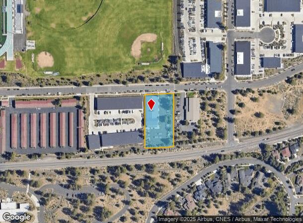
Property Record
2765 Nw Lolo Dr, Bend, OR 97703
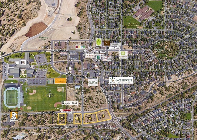


NEARBY LISTINGS FOR SALE OR LEASE
Property Detail
2765 Nw Lolo Dr
Bend, OR
Northwest Crossing District 2
257935
NORTHWEST CROSSING DISTRICT 2 LOT 7
Industrialgeneral
Deschutes
X
Oregon
41017C0661E
7
2025
1.13 AC
2025
Deschutes County
001302
Portland
9,745 SF
DEMOGRAPHICS near 2765 Nw Lolo Dr
1 Mile
3 Mile
5 Mile
2024 Total Population
6,132
43,465
101,797
2029 Population
6,925
48,957
113,653
Pop Growth 2024-2029
+ 12.93%
+ 12.64%
+ 11.65%
Average Age
44
42
41
2024 Total Households
2,549
18,071
41,952
HH Growth 2024-2029
+ 13.06%
+ 12.81%
+ 11.79%
Median Household Inc
$136,312
$102,585
$84,571
Avg Household Size
2.40
2.30
2.40
2024 Avg HH Vehicles
2.00
2.00
2.00
Median Home Value
$896,194
$790,479
$636,165
Median Year Built
2008
2002
1999
Nearby Places
Map Layers
Map Styles
 Street
 Aerial
- Restaurants
- Banks
- Shops
- Fitness
- Groceries
PUBLIC TRANSPORTATION
AIRPORT
Roberts Field
DRIVE
WALK
Distance
Roberts Field
33 min
20.3 mi
Freight Ports
Port of Portland
DRIVE
WALK
Distance
Port of Portland
241 min
181.0 mi
SALE & LEASE HISTORY
LISTING DATE
SALE/LEASE

Oct 28, 2016
For Sale
Nearby Properties
Address
Land Use
TOTAL SIZE
Lot Size
Zoning
Address
Land Use
TOTAL SIZE
Lot Size
Zoning
3.74 AC
MR
Address
Land Use
TOTAL SIZE
Lot Size
Zoning
25,574 SF
3.74 AC
MR
Address
Land Use
TOTAL SIZE
Lot Size
Zoning
27,863 SF
4.23 AC
MU
Address
Land Use
TOTAL SIZE
Lot Size
Zoning
318,598 SF
9.77 AC
RS
Address
Land Use
TOTAL SIZE
Lot Size
Zoning
166,371 SF
2.52 AC
MU
Address
Land Use
TOTAL SIZE
Lot Size
Zoning
199,892 SF
19.16 AC
CG
Address
Land Use
TOTAL SIZE
Lot Size
Zoning
1.04 AC
CB
Address
Land Use
TOTAL SIZE
Lot Size
Zoning
201,575 SF
1.04 AC
CB
Address
Land Use
TOTAL SIZE
Lot Size
Zoning
129,449 SF
2.91 AC
MR
Address
Land Use
TOTAL SIZE
Lot Size
Zoning
46,317 SF
5.67 AC
RM
Address
Land Use
TOTAL SIZE
Lot Size
Zoning
170,218 SF
13.27 AC
RS
Address
Land Use
TOTAL SIZE
Lot Size
Zoning
21.41 AC
MU
Address
Land Use
TOTAL SIZE
Lot Size
Zoning
88,619 SF
2.17 AC
ME
Address
Land Use
TOTAL SIZE
Lot Size
Zoning
2.17 AC
Address
Land Use
TOTAL SIZE
Lot Size
Zoning
105,069 SF
4.97 AC
RS
Address
Land Use
TOTAL SIZE
Lot Size
Zoning
164,959 SF
9.30 AC
CG
Address
Land Use
TOTAL SIZE
Lot Size
Zoning
164,959 SF
9.30 AC
CG
Address
Land Use
TOTAL SIZE
Lot Size
Zoning
7.73 AC
MR
Address
Land Use
TOTAL SIZE
Lot Size
Zoning
7.73 AC
MR
Address
Land Use
TOTAL SIZE
Lot Size
Zoning
125,966 SF
8.19 AC
RS
Address
Land Use
TOTAL SIZE
Lot Size
Zoning
6,321 SF
8.32 AC
MR
Address
Land Use
TOTAL SIZE
Lot Size
Zoning
89,486 SF
8.32 AC
MR
Address
Land Use
TOTAL SIZE
Lot Size
Zoning
7,322 SF
8.32 AC
MR
Address
Land Use
TOTAL SIZE
Lot Size
Zoning
86,455 SF
7.55 AC
MU
Address
Land Use
TOTAL SIZE
Lot Size
Zoning
67,972 SF
5.10 AC
MR
Address
Land Use
TOTAL SIZE
Lot Size
Zoning
146.29 AC
PF
Address
Land Use
TOTAL SIZE
Lot Size
Zoning
146.29 AC
Address
Land Use
TOTAL SIZE
Lot Size
Zoning
146.29 AC
PF
Address
Land Use
TOTAL SIZE
Lot Size
Zoning
61,568 SF
1.13 AC
MU
Address
Land Use
TOTAL SIZE
Lot Size
Zoning
87,170 SF
2.20 AC
MR
The World's #1 Commercial Real Estate Marketplace
Connect with us
© 2026 CoStar Group
The information above has been obtained from sources believed reliable. While we do not doubt its accuracy we have not verified it and make no guarantee, warranty or representation about it. It is your responsibility to independently confirm its accuracy and completeness. Any projections, opinions, assumptions, or estimates used are for example only and do not represent the current or future performance of the property. The value of this transaction to you depends on tax and other factors which should be evaluated by your tax, financial, and legal advisors. You and your advisors should conduct a careful, independent investigation of the property to determine to your satisfaction the suitability of the property for your needs.