Property Record
277 S 5Th St, Brooklyn, NY 11211
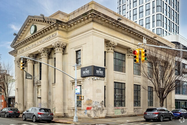
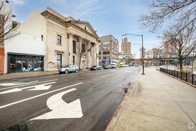
Property Detail
277 S 5Th St
02447-1007
KINGS
Storebuilding
New York
C4-3
1006
B and X Area of moderate flood hazard, usually the area between the limits of the 100-year and 500-year floods.
1.16 AC
2024
North Brooklyn
2025
Long Island (New York)
052500
New York-Jersey City-White Plains, NY-NJ
17,446 SF
NEARBY LISTINGS FOR SALE OR LEASE
DEMOGRAPHICS near 277 S 5Th St
1 mile
3 mile
5 mile
2025 Total Population
176,371
1,405,074
3,203,333
2030 Population
179,897
1,437,586
3,264,503
Pop Growth 2025-2030
+ 2.00%
+ 2.31%
+ 1.91%
Average Age
34
38
39
2025 Total Households
66,117
613,907
1,377,932
HH Growth 2025-2030
+ 1.84%
+ 2.50%
+ 2.34%
Median Household Inc
$94,206
$110,854
$104,299
Avg Household Size
2.60
2.20
2.20
2025 Avg HH Vehicles
.00
.00
.00
Median Home Value
$1,032,293
$1,030,509
$955,231
Median Year Built
1975
1949
1952
Nearby Places
Map Layers
Map Styles
 Street
 Aerial
Transit
 Traffic
 Biking
Places
Listings with unknown addresses are not visible on the map
- Restaurants
- Banks
- Shops
- Fitness
- Groceries
PUBLIC TRANSPORTATION
TRANSIT/SUBWAY
Marcy Avenue (J - New York MTA Subway (The Subway), M - New York MTA Subway (The Subway), Z - New York MTA Subway (The Subway))
Drive
Walk
Distance
Marcy Avenue (J - New York MTA Subway (The Subway), M - New York MTA Subway (The Subway), Z - New York MTA Subway (The Subway))
0 min
1 min
0.1 mi
Hewes Street (J - New York MTA Subway (The Subway), M - New York MTA Subway (The Subway))
Drive
Walk
Distance
Hewes Street (J - New York MTA Subway (The Subway), M - New York MTA Subway (The Subway))
1 min
7 min
0.4 mi
Metropolitan Avenue (G - New York MTA Subway (The Subway))
Drive
Walk
Distance
Metropolitan Avenue (G - New York MTA Subway (The Subway))
1 min
10 min
0.5 mi
Broadway (G Line) (G - New York MTA Subway (The Subway))
Drive
Walk
Distance
Broadway (G Line) (G - New York MTA Subway (The Subway))
2 min
10 min
0.5 mi
Bedford Avenue (L - New York MTA Subway (The Subway))
Drive
Walk
Distance
Bedford Avenue (L - New York MTA Subway (The Subway))
3 min
13 min
0.7 mi
COMMUTER RAIL
Atlantic Terminal (Babylon Branch - Long Island Rail Road, City Terminal Zone - Long Island Rail Road, Hempstead Branch - Long Island Rail Road, West Hempstead Branch - Long Island Rail Road)
Drive
Walk
Distance
Atlantic Terminal (Babylon Branch - Long Island Rail Road, City Terminal Zone - Long Island Rail Road, Hempstead Branch - Long Island Rail Road, West Hempstead Branch - Long Island Rail Road)
7 min
2.8 mi
Long Island City Station (Hempstead Branch - Long Island Rail Road)
Drive
Walk
Distance
Long Island City Station (Hempstead Branch - Long Island Rail Road)
10 min
3.3 mi
AIRPORT
LaGuardia
Drive
Walk
Distance
LaGuardia
16 min
7.4 mi
John F Kennedy International
Drive
Walk
Distance
John F Kennedy International
25 min
13.3 mi
Newark Liberty International
Drive
Walk
Distance
Newark Liberty International
25 min
14.6 mi
Freight Ports
NY - Red Hook Container Terminal
Drive
Walk
Distance
NY - Red Hook Container Terminal
9 min
4.2 mi
SALE & LEASE HISTORY
LISTING DATE
SALE/LEASE

Mar 06, 2019
For Lease
Nearby Properties
Address
Land Use
TOTAL SIZE
Lot Size
Zoning
Address
Land Use
TOTAL SIZE
Lot Size
Zoning
8,462,176 SF
61.41 AC
R7-2
Address
Land Use
TOTAL SIZE
Lot Size
Zoning
2,354,289 SF
3.96 AC
C6-4
Address
Land Use
TOTAL SIZE
Lot Size
Zoning
2,812,739 SF
2.10 AC
C5-3
Address
Land Use
TOTAL SIZE
Lot Size
Zoning
2,157,862 SF
2.23 AC
BPC
Address
Land Use
TOTAL SIZE
Lot Size
Zoning
2,400,000 SF
15.14 AC
C5-2
Address
Land Use
TOTAL SIZE
Lot Size
Zoning
2,124,441 SF
17.29 AC
R8
Address
Land Use
TOTAL SIZE
Lot Size
Zoning
2,233,692 SF
1.90 AC
BPC
Address
Land Use
TOTAL SIZE
Lot Size
Zoning
1,233,394 SF
1.78 AC
C5-3
Address
Land Use
TOTAL SIZE
Lot Size
Zoning
1,104,505 SF
2.32 AC
C4-7
Address
Land Use
TOTAL SIZE
Lot Size
Zoning
1,560,607 SF
2.69 AC
C6-6
Address
Land Use
TOTAL SIZE
Lot Size
Zoning
1,636,000 SF
1.09 AC
C6-4
Address
Land Use
TOTAL SIZE
Lot Size
Zoning
940,000 SF
1.44 AC
C6-2
Address
Land Use
TOTAL SIZE
Lot Size
Zoning
7,058,736 SF
147.61 AC
M3-1
Address
Land Use
TOTAL SIZE
Lot Size
Zoning
869,038 SF
1.53 AC
M1-1
Address
Land Use
TOTAL SIZE
Lot Size
Zoning
1,260,362 SF
4.32 AC
C1-7
Address
Land Use
TOTAL SIZE
Lot Size
Zoning
802,000 SF
1.20 AC
C62A
Address
Land Use
TOTAL SIZE
Lot Size
Zoning
3,122,165 SF
19.02 AC
R7-2
Address
Land Use
TOTAL SIZE
Lot Size
Zoning
2,210,200 SF
2.58 AC
C5-5
Address
Land Use
TOTAL SIZE
Lot Size
Zoning
1,362,190 SF
C5-5
Address
Land Use
TOTAL SIZE
Lot Size
Zoning
1,653,794 SF
3.15 AC
C6-4
Address
Land Use
TOTAL SIZE
Lot Size
Zoning
704,950 SF
1.19 AC
C5-2
Address
Land Use
TOTAL SIZE
Lot Size
Zoning
932,587 SF
1.23 AC
C5-3
Address
Land Use
TOTAL SIZE
Lot Size
Zoning
972,820 SF
1.98 AC
M1-6
Address
Land Use
TOTAL SIZE
Lot Size
Zoning
1,499,568 SF
1.66 AC
C5-5
Address
Land Use
TOTAL SIZE
Lot Size
Zoning
1,043,803 SF
1.59 AC
M1-6
Address
Land Use
TOTAL SIZE
Lot Size
Zoning
1,065,915 SF
2.13 AC
M16R10
Address
Land Use
TOTAL SIZE
Lot Size
Zoning
1,385,425 SF
6.43 AC
R8
Address
Land Use
TOTAL SIZE
Lot Size
Zoning
1,740,736 SF
4.29 AC
C6-4
Address
Land Use
TOTAL SIZE
Lot Size
Zoning
1,617,206 SF
1.23 AC
C5-5
Address
Land Use
TOTAL SIZE
Lot Size
Zoning
553,725 SF
0.84 AC
C5-2
The World's #1 Commercial Real Estate Marketplace
Connect with us
© 2026 CoStar Group
The information above has been obtained from sources believed reliable. While we do not doubt its accuracy we have not verified it and make no guarantee, warranty or representation about it. It is your responsibility to independently confirm its accuracy and completeness. Any projections, opinions, assumptions, or estimates used are for example only and do not represent the current or future performance of the property. The value of this transaction to you depends on tax and other factors which should be evaluated by your tax, financial, and legal advisors. You and your advisors should conduct a careful, independent investigation of the property to determine to your satisfaction the suitability of the property for your needs.