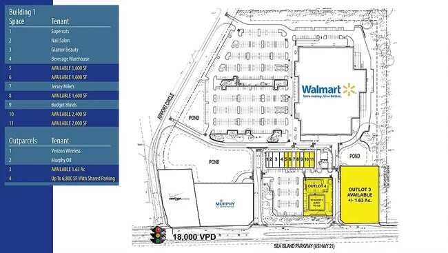
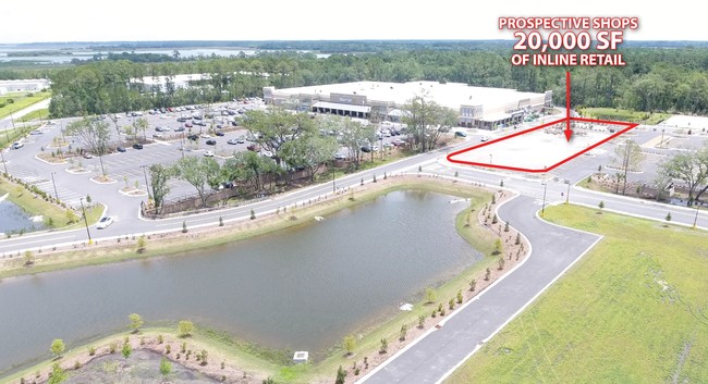
Property Record
277 Sea Island Pkwy, Beaufort, SC 29907
NEARBY LISTINGS FOR SALE OR LEASE
Property Detail
277 Sea Island Pkwy
Hilton Head Island-Bluffton-Beaufort, SC
Ladys Is. Zoned Lt.Ind. & Dis
R123-018-000-0777-0000
SHOPS TRACT PB142 P196~SPLIT 3/22 .946 AC 18/797 PB158 P20
Stripcommercialcenter
Beaufort
2025
South Carolina
2024
2.25 AC
000902
Hilton Head/Beaufort
20,250 SF
Other Market Areas
DEMOGRAPHICS near 277 Sea Island Pkwy
1 Mile
3 Mile
5 Mile
2024 Total Population
937
8,340
30,665
2029 Population
1,036
9,230
33,819
Pop Growth 2024-2029
+ 10.57%
+ 10.67%
+ 10.29%
Average Age
42
43
42
2024 Total Households
367
3,408
12,645
HH Growth 2024-2029
+ 10.08%
+ 10.27%
+ 10.03%
Median Household Inc
$66,041
$67,766
$63,068
Avg Household Size
2.50
2.30
2.30
2024 Avg HH Vehicles
2.00
2.00
2.00
Median Home Value
$557,065
$376,712
$329,560
Median Year Built
1999
1993
1990
Nearby Places
- Restaurants
- Banks
- Shops
- Fitness
- Groceries
PUBLIC TRANSPORTATION
AIRPORT
Hilton Head
DRIVE
WALK
Distance
Hilton Head
58 min
41.4 mi
Freight Ports
Georgia Ports - Savannah
DRIVE
WALK
Distance
Georgia Ports - Savannah
67 min
50.8 mi
SALE & LEASE HISTORY
LISTING DATE
SALE/LEASE

Sep 26, 2017
For Lease
Sep 24, 2016
For Sale
Nearby Properties
Address
Land Use
TOTAL SIZE
Lot Size
Zoning
Address
Land Use
TOTAL SIZE
Lot Size
Zoning
144,673 SF
19.30 AC
4201
Address
Land Use
TOTAL SIZE
Lot Size
Zoning
144,226 SF
41.30 AC
6611
Address
Land Use
TOTAL SIZE
Lot Size
Zoning
16,197 SF
7.50 AC
6611
Address
Land Use
TOTAL SIZE
Lot Size
Zoning
53,862 SF
6.67 AC
9999
Address
Land Use
TOTAL SIZE
Lot Size
Zoning
58,085 SF
19.97 AC
6612
Address
Land Use
TOTAL SIZE
Lot Size
Zoning
41,760 SF
8.75 AC
6612
Address
Land Use
TOTAL SIZE
Lot Size
Zoning
62,860 SF
6.26 AC
6611
Address
Land Use
TOTAL SIZE
Lot Size
Zoning
81,955 SF
5.82 AC
4202
Address
Land Use
TOTAL SIZE
Lot Size
Zoning
33,157 SF
0.92 AC
6611
Address
Land Use
TOTAL SIZE
Lot Size
Zoning
1.15 AC
Address
Land Use
TOTAL SIZE
Lot Size
Zoning
38,260 SF
10 AC
6611
Address
Land Use
TOTAL SIZE
Lot Size
Zoning
34,800 SF
4.31 AC
6602
Address
Land Use
TOTAL SIZE
Lot Size
Zoning
8.92 AC
6611
Address
Land Use
TOTAL SIZE
Lot Size
Zoning
31,175 SF
2.09 AC
6611
Address
Land Use
TOTAL SIZE
Lot Size
Zoning
640 SF
232.74 AC
9999
Address
Land Use
TOTAL SIZE
Lot Size
Zoning
32,324 SF
7.29 AC
6612
Address
Land Use
TOTAL SIZE
Lot Size
Zoning
20,231 SF
118.67 AC
6612
Address
Land Use
TOTAL SIZE
Lot Size
Zoning
22,333 SF
5.98 AC
6612
Address
Land Use
TOTAL SIZE
Lot Size
Zoning
14,320 SF
1.38 AC
6101
Address
Land Use
TOTAL SIZE
Lot Size
Zoning
28,320 SF
0.85 AC
6611
Address
Land Use
TOTAL SIZE
Lot Size
Zoning
77,783 SF
4.46 AC
6101
Address
Land Use
TOTAL SIZE
Lot Size
Zoning
100 SF
9.68 AC
6601
Address
Land Use
TOTAL SIZE
Lot Size
Zoning
35,825 SF
4.35 AC
6612
Address
Land Use
TOTAL SIZE
Lot Size
Zoning
37,845 SF
7.32 AC
6611
Address
Land Use
TOTAL SIZE
Lot Size
Zoning
28,775 SF
5.18 AC
6611
Address
Land Use
TOTAL SIZE
Lot Size
Zoning
14,490 SF
1.64 AC
6611
Address
Land Use
TOTAL SIZE
Lot Size
Zoning
12,327 SF
1.95 AC
6602
Address
Land Use
TOTAL SIZE
Lot Size
Zoning
2,824 SF
0.95 AC
6612
Address
Land Use
TOTAL SIZE
Lot Size
Zoning
4,826 SF
27.02 AC
6612
The World's #1 Commercial Real Estate Marketplace
Connect with us
© 2025 CoStar Group
The information above has been obtained from sources believed reliable. While we do not doubt its accuracy we have not verified it and make no guarantee, warranty or representation about it. It is your responsibility to independently confirm its accuracy and completeness. Any projections, opinions, assumptions, or estimates used are for example only and do not represent the current or future performance of the property. The value of this transaction to you depends on tax and other factors which should be evaluated by your tax, financial, and legal advisors. You and your advisors should conduct a careful, independent investigation of the property to determine to your satisfaction the suitability of the property for your needs.