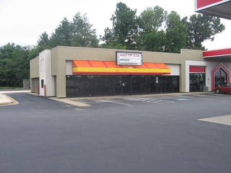
Property Record
2770 Springs Rd Ne, Hickory, NC 28601

NEARBY LISTINGS FOR SALE OR LEASE
Property Detail
2770 Springs Rd Ne
Hickory-Lenoir-Morganton, NC
Quality Oil Company Limited Partnershio
3723104711740000
LOT A PLAT 37-88
Conveniencestore
Catawba
X
North Carolina
3710372300J
a
2024
0.80 AC
2025
Catawba County
010303
Charlotte
1,568 SF
DEMOGRAPHICS near 2770 Springs Rd Ne
1 Mile
3 Mile
5 Mile
2024 Total Population
4,313
32,632
72,064
2029 Population
4,484
34,112
75,146
Pop Growth 2024-2029
+ 3.96%
+ 4.54%
+ 4.28%
Average Age
40
40
41
2024 Total Households
1,712
13,509
29,597
HH Growth 2024-2029
+ 4.03%
+ 4.52%
+ 4.25%
Median Household Inc
$50,382
$51,770
$57,016
Avg Household Size
2.50
2.30
2.30
2024 Avg HH Vehicles
2.00
2.00
2.00
Median Home Value
$163,192
$174,167
$198,381
Median Year Built
1978
1982
1982
Nearby Places
Map Layers
Map Styles
 Street
 Aerial
- Restaurants
- Banks
- Shops
- Fitness
- Groceries
Nearby Properties
Address
Land Use
TOTAL SIZE
Lot Size
Zoning
Address
Land Use
TOTAL SIZE
Lot Size
Zoning
83,982 SF
96.78 AC
OI
Address
Land Use
TOTAL SIZE
Lot Size
Zoning
8,492 SF
15.83 AC
R-4
Address
Land Use
TOTAL SIZE
Lot Size
Zoning
16,594 SF
7.22 AC
PD
Address
Land Use
TOTAL SIZE
Lot Size
Zoning
19.87 AC
OI
Address
Land Use
TOTAL SIZE
Lot Size
Zoning
27,008 SF
12.02 AC
R-3
Address
Land Use
TOTAL SIZE
Lot Size
Zoning
94,152 SF
14.46 AC
IND
Address
Land Use
TOTAL SIZE
Lot Size
Zoning
7,722 SF
10.01 AC
R-4
Address
Land Use
TOTAL SIZE
Lot Size
Zoning
57,658 SF
10.64 AC
OI
Address
Land Use
TOTAL SIZE
Lot Size
Zoning
326,813 SF
37.87 AC
IND
Address
Land Use
TOTAL SIZE
Lot Size
Zoning
8,436 SF
13.28 AC
R-4
Address
Land Use
TOTAL SIZE
Lot Size
Zoning
353,092 SF
35.72 AC
IND
Address
Land Use
TOTAL SIZE
Lot Size
Zoning
1,726 SF
15.93 AC
PD
Address
Land Use
TOTAL SIZE
Lot Size
Zoning
8,992 SF
11.66 AC
R-4
Address
Land Use
TOTAL SIZE
Lot Size
Zoning
42.11 AC
R-20
Address
Land Use
TOTAL SIZE
Lot Size
Zoning
8,960 SF
14.07 AC
R-4
Address
Land Use
TOTAL SIZE
Lot Size
Zoning
14.15 AC
OI
Address
Land Use
TOTAL SIZE
Lot Size
Zoning
60,130 SF
4.02 AC
IND
Address
Land Use
TOTAL SIZE
Lot Size
Zoning
6,144 SF
11.37 AC
R-4
Address
Land Use
TOTAL SIZE
Lot Size
Zoning
15,164 SF
8.29 AC
PD
Address
Land Use
TOTAL SIZE
Lot Size
Zoning
27,426 SF
7.99 AC
PD
Address
Land Use
TOTAL SIZE
Lot Size
Zoning
7,742 SF
10.93 AC
PD
Address
Land Use
TOTAL SIZE
Lot Size
Zoning
22.99 AC
PD
Address
Land Use
TOTAL SIZE
Lot Size
Zoning
44,116 SF
6.33 AC
OI
Address
Land Use
TOTAL SIZE
Lot Size
Zoning
72,388 SF
7.57 AC
R-2
Address
Land Use
TOTAL SIZE
Lot Size
Zoning
20.34 AC
R-20
Address
Land Use
TOTAL SIZE
Lot Size
Zoning
31.22 AC
R-1
Address
Land Use
TOTAL SIZE
Lot Size
Zoning
132,633 SF
24.64 AC
IND
Address
Land Use
TOTAL SIZE
Lot Size
Zoning
55,384 SF
3.88 AC
IND
Address
Land Use
TOTAL SIZE
Lot Size
Zoning
8,246 SF
37.33 AC
OI
Address
Land Use
TOTAL SIZE
Lot Size
Zoning
28.97 AC
R-20
The World's #1 Commercial Real Estate Marketplace
Connect with us
© 2025 CoStar Group
The information above has been obtained from sources believed reliable. While we do not doubt its accuracy we have not verified it and make no guarantee, warranty or representation about it. It is your responsibility to independently confirm its accuracy and completeness. Any projections, opinions, assumptions, or estimates used are for example only and do not represent the current or future performance of the property. The value of this transaction to you depends on tax and other factors which should be evaluated by your tax, financial, and legal advisors. You and your advisors should conduct a careful, independent investigation of the property to determine to your satisfaction the suitability of the property for your needs.