Property Record
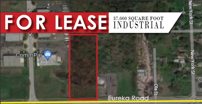
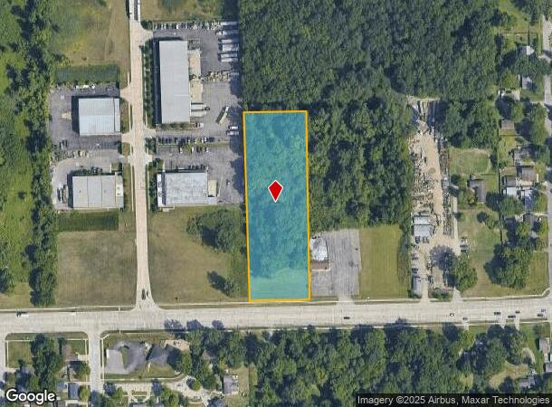
Eureka, Romulus, MI 48174
This Property Is For Sale
NEARBY LISTINGS FOR SALE OR LEASE
Property Detail
Eureka
Detroit-Warren-Dearborn, MI
Victory Garden
80-100-99-0014-001
25MM1A THE W 3.00 AC OF SW 1/4 OF SE 1/4 OF SE 1/4 OF SEC 25 T3S R9E EXC S 60FT THEREOF 2.73 AC
Industrialacreage
Wayne
X
Michigan
26163C0383E
0014
2024
2.73 AC
2025
Airport District
985400
Detroit
DEMOGRAPHICS near Eureka
1 Mile
3 Mile
5 Mile
2024 Total Population
6,194
29,958
92,622
2029 Population
5,862
28,679
89,069
Pop Growth 2024-2029
(5.36%)
(4.27%)
(3.84%)
Average Age
34
39
41
2024 Total Households
2,252
11,727
37,586
HH Growth 2024-2029
(5.46%)
(4.31%)
(3.85%)
Median Household Inc
$52,841
$58,719
$59,872
Avg Household Size
2.60
2.50
2.40
2024 Avg HH Vehicles
2.00
2.00
2.00
Median Home Value
$157,318
$162,023
$167,272
Median Year Built
1975
1973
1971
Nearby Places
- Restaurants
- Banks
- Shops
- Fitness
- Groceries
PUBLIC TRANSPORTATION
AIRPORT
Detroit Metro Wayne County
DRIVE
WALK
Distance
Detroit Metro Wayne County
7 min
4.4 mi
Windsor International
DRIVE
WALK
Distance
Windsor International
46 min
27.5 mi
Freight Ports
Port of Toledo
DRIVE
WALK
Distance
Port of Toledo
63 min
49.4 mi
Nearby Properties
Address
Land Use
TOTAL SIZE
Lot Size
Zoning
Address
Land Use
TOTAL SIZE
Lot Size
Zoning
307,524 SF
63.94 AC
AP-AIRPORT
Address
Land Use
TOTAL SIZE
Lot Size
Zoning
553,004 SF
61.46 AC
B-2
Address
Land Use
TOTAL SIZE
Lot Size
Zoning
3,122,068 SF
260 AC
I-1
Address
Land Use
TOTAL SIZE
Lot Size
Zoning
217,726 SF
27.60 AC
B-2
Address
Land Use
TOTAL SIZE
Lot Size
Zoning
268,272 SF
22.70 AC
M-1/COND
Address
Land Use
TOTAL SIZE
Lot Size
Zoning
244,760 SF
22.63 AC
M-1/COND
Address
Land Use
TOTAL SIZE
Lot Size
Zoning
260,000 SF
20.50 AC
M-T
Address
Land Use
TOTAL SIZE
Lot Size
Zoning
302,868 SF
19.94 AC
M-T
Address
Land Use
TOTAL SIZE
Lot Size
Zoning
131,205 SF
13.95 AC
B-2
Address
Land Use
TOTAL SIZE
Lot Size
Zoning
312,000 SF
21.91 AC
M-T
Address
Land Use
TOTAL SIZE
Lot Size
Zoning
299,904 SF
20.13 AC
M-T
Address
Land Use
TOTAL SIZE
Lot Size
Zoning
299,904 SF
18.68 AC
M-T
Address
Land Use
TOTAL SIZE
Lot Size
Zoning
166,950 SF
22.86 AC
RM-MLTI
Address
Land Use
TOTAL SIZE
Lot Size
Zoning
1,278 SF
17.59 AC
M-T
Address
Land Use
TOTAL SIZE
Lot Size
Zoning
236,908 SF
29.21 AC
B-2
Address
Land Use
TOTAL SIZE
Lot Size
Zoning
129,260 SF
5.25 AC
AP-AIRPORT
Address
Land Use
TOTAL SIZE
Lot Size
Zoning
261,835 SF
45.99 AC
M-T
Address
Land Use
TOTAL SIZE
Lot Size
Zoning
229,395 SF
15.46 AC
RM-1
Address
Land Use
TOTAL SIZE
Lot Size
Zoning
202,394 SF
15.29 AC
RM-1
Address
Land Use
TOTAL SIZE
Lot Size
Zoning
235,200 SF
21.93 AC
M-T
Address
Land Use
TOTAL SIZE
Lot Size
Zoning
32,767 SF
17.81 AC
RM-1
Address
Land Use
TOTAL SIZE
Lot Size
Zoning
207,205 SF
28.02 AC
I-1
Address
Land Use
TOTAL SIZE
Lot Size
Zoning
292,254 SF
23.61 AC
RM-1
Address
Land Use
TOTAL SIZE
Lot Size
Zoning
266,094 SF
22.92 AC
M-T
Address
Land Use
TOTAL SIZE
Lot Size
Zoning
83,540 SF
2.90 AC
RM-2
Address
Land Use
TOTAL SIZE
Lot Size
Zoning
82,615 SF
15 AC
B-3
Address
Land Use
TOTAL SIZE
Lot Size
Zoning
178,996 SF
15.06 AC
RM-1
Address
Land Use
TOTAL SIZE
Lot Size
Zoning
237,058 SF
2.82 AC
B-2
Address
Land Use
TOTAL SIZE
Lot Size
Zoning
169,350 SF
12.45 AC
I-1
Address
Land Use
TOTAL SIZE
Lot Size
Zoning
176,500 SF
13.56 AC
I-1
The World's #1 Commercial Real Estate Marketplace
Connect with us
© 2025 CoStar Group
The information above has been obtained from sources believed reliable. While we do not doubt its accuracy we have not verified it and make no guarantee, warranty or representation about it. It is your responsibility to independently confirm its accuracy and completeness. Any projections, opinions, assumptions, or estimates used are for example only and do not represent the current or future performance of the property. The value of this transaction to you depends on tax and other factors which should be evaluated by your tax, financial, and legal advisors. You and your advisors should conduct a careful, independent investigation of the property to determine to your satisfaction the suitability of the property for your needs.