Property Record
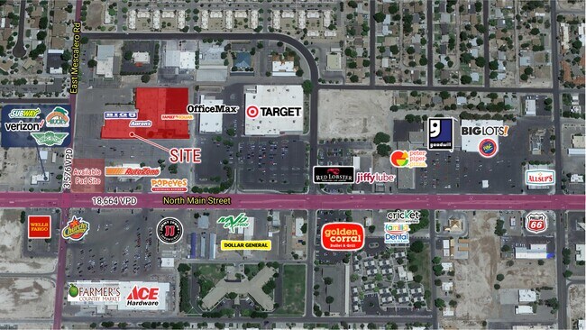
2775 N Main St, Roswell, NM 88201

Property Detail
2775 N Main St
R006664
SUBD: WILSHIRE LOT: 1 QUARTER: SW S: 21 T: 10S R: 24E DOC# 202104753 WD
Realpropertynec
Chaves
COMMUNITY
New Mexico
B and X Area of moderate flood hazard, usually the area between the limits of the 100-year and 500-year floods.
1
2024
0.82 AC
2025
New Mexico South Area
001002
Other Market Areas
3,205 SF
Roswell, NM
NEARBY LISTINGS FOR SALE OR LEASE
DEMOGRAPHICS near 2775 N Main St
1 mile
3 mile
5 mile
2025 Total Population
8,902
26,434
46,911
2030 Population
8,775
26,239
46,419
Pop Growth 2025-2030
(1.43%)
(0.74%)
(1.05%)
Average Age
41
39
39
2025 Total Households
3,478
10,142
17,659
HH Growth 2025-2030
(1.44%)
(0.83%)
(1.14%)
Median Household Inc
$69,233
$54,848
$52,723
Avg Household Size
2.50
2.50
2.60
2025 Avg HH Vehicles
2.00
2.00
2.00
Median Home Value
$254,957
$202,423
$170,831
Median Year Built
1982
1972
1970
Nearby Places
Map Layers
Map Styles
 Street
 Aerial
Layers
 Traffic
 Biking
Places
Listings with unknown addresses are not visible on the map
- Restaurants
- Banks
- Shops
- Fitness
- Groceries
PUBLIC TRANSPORTATION
AIRPORT
Roswell Air Center
Drive
Walk
Distance
Roswell Air Center
20 min
9.2 mi
Freight Ports
Tulsa Port Of Catoosa
Drive
Walk
Distance
Tulsa Port Of Catoosa
636 min
586.7 mi
SALE & LEASE HISTORY
LISTING DATE
SALE/LEASE

Dec 31, 2019
For Sale
Nearby Properties
Address
Land Use
TOTAL SIZE
Lot Size
Zoning
Address
Land Use
TOTAL SIZE
Lot Size
Zoning
1,829,640 SF
3.68 AC
CENTRAL BU
Address
Land Use
TOTAL SIZE
Lot Size
Zoning
10,644 SF
5.81 AC
COMMUNITY
Address
Land Use
TOTAL SIZE
Lot Size
Zoning
23.93 AC
RESIDENTIA
Address
Land Use
TOTAL SIZE
Lot Size
Zoning
230,872 SF
9.40 AC
COMMUNITY
Address
Land Use
TOTAL SIZE
Lot Size
Zoning
2.54 AC
RESIDENTIA
Address
Land Use
TOTAL SIZE
Lot Size
Zoning
2.58 AC
COMMUNITY
Address
Land Use
TOTAL SIZE
Lot Size
Zoning
150.96 AC
RESIDENTIA
Address
Land Use
TOTAL SIZE
Lot Size
Zoning
1.59 AC
CENTRAL BU
Address
Land Use
TOTAL SIZE
Lot Size
Zoning
56.23 AC
Address
Land Use
TOTAL SIZE
Lot Size
Zoning
18,630 SF
9.10 AC
COMMUNITY
Address
Land Use
TOTAL SIZE
Lot Size
Zoning
17,567 SF
1.24 AC
RESIDENTIA
Address
Land Use
TOTAL SIZE
Lot Size
Zoning
6.47 AC
RESIDENTIA
Address
Land Use
TOTAL SIZE
Lot Size
Zoning
203,209 SF
22.13 AC
COMMUNITY
Address
Land Use
TOTAL SIZE
Lot Size
Zoning
9.52 AC
RESIDENTIA
Address
Land Use
TOTAL SIZE
Lot Size
Zoning
3.58 AC
RESIDENTIA
Address
Land Use
TOTAL SIZE
Lot Size
Zoning
2.10 AC
CENTRAL BU
Address
Land Use
TOTAL SIZE
Lot Size
Zoning
9.05 AC
Address
Land Use
TOTAL SIZE
Lot Size
Zoning
Address
Land Use
TOTAL SIZE
Lot Size
Zoning
134,448 SF
15.85 AC
COMMUNITY
Address
Land Use
TOTAL SIZE
Lot Size
Zoning
38,671 SF
6.59 AC
COMMUNITY
Address
Land Use
TOTAL SIZE
Lot Size
Zoning
21,500 SF
4.78 AC
COMMUNITY
Address
Land Use
TOTAL SIZE
Lot Size
Zoning
2.61 AC
RESIDENTIA
Address
Land Use
TOTAL SIZE
Lot Size
Zoning
44,153 SF
1.29 AC
CENTRAL BU
Address
Land Use
TOTAL SIZE
Lot Size
Zoning
20.23 AC
RESIDENTIA
Address
Land Use
TOTAL SIZE
Lot Size
Zoning
39,382 SF
1.90 AC
COMMUNITY
Address
Land Use
TOTAL SIZE
Lot Size
Zoning
29.09 AC
RESIDENTIA
Address
Land Use
TOTAL SIZE
Lot Size
Zoning
6.48 AC
RESIDENTIA
Address
Land Use
TOTAL SIZE
Lot Size
Zoning
39,383 SF
2.11 AC
COMMUNITY
Address
Land Use
TOTAL SIZE
Lot Size
Zoning
1,126 SF
0.14 AC
RESIDENTIA
Address
Land Use
TOTAL SIZE
Lot Size
Zoning
13.85 AC
RESIDENTIA
The World's #1 Commercial Real Estate Marketplace
Connect with us
© 2026 CoStar Group
The information above has been obtained from sources believed reliable. While we do not doubt its accuracy we have not verified it and make no guarantee, warranty or representation about it. It is your responsibility to independently confirm its accuracy and completeness. Any projections, opinions, assumptions, or estimates used are for example only and do not represent the current or future performance of the property. The value of this transaction to you depends on tax and other factors which should be evaluated by your tax, financial, and legal advisors. You and your advisors should conduct a careful, independent investigation of the property to determine to your satisfaction the suitability of the property for your needs.