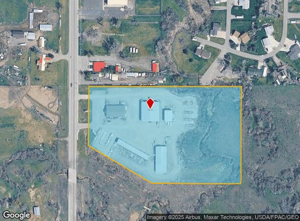
Property Record
2775 Roundup Rd, Billings, MT 59105
NEARBY LISTINGS FOR SALE OR LEASE
Property Detail
2775 Roundup Rd
Billings, MT
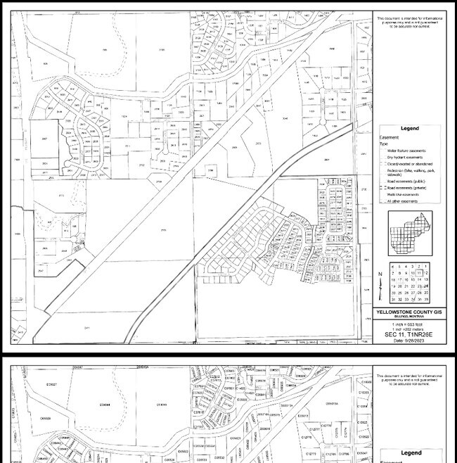
Clear Creek Subd
03-1033-11-3-09-10-0000
CLEAR CREEK SUBD, S11, T01 N, R26 E, BLOCK 1, LOT 2A, AMD LT 2& 1A (01)&(03) 9.707 AC
Commercialnec
Yellowstone
AE
Montana
30111C1280E
2a
2024
9.71 AC
2025
Billings
001402
Other Market Areas
30,823 SF
DEMOGRAPHICS near 2775 Roundup Rd
1 Mile
3 Mile
5 Mile
2024 Total Population
2,984
31,597
49,685
2029 Population
3,177
34,134
53,325
Pop Growth 2024-2029
+ 6.47%
+ 8.03%
+ 7.33%
Average Age
39
39
39
2024 Total Households
1,128
12,359
19,873
HH Growth 2024-2029
+ 6.65%
+ 8.16%
+ 7.45%
Median Household Inc
$80,706
$71,383
$70,176
Avg Household Size
2.60
2.50
2.40
2024 Avg HH Vehicles
3.00
2.00
2.00
Median Home Value
$320,958
$277,087
$285,267
Median Year Built
1990
1990
1983
Nearby Places
Map Layers
Map Styles
 Street
 Aerial
- Restaurants
- Banks
- Shops
- Fitness
- Groceries
PUBLIC TRANSPORTATION
AIRPORT
Billings Logan International
DRIVE
WALK
Distance
Billings Logan International
25 min
9.6 mi
Freight Ports
Port of Everett
DRIVE
WALK
Distance
Port of Everett
894 min
846.8 mi
Nearby Properties
Address
Land Use
TOTAL SIZE
Lot Size
Zoning
Address
Land Use
TOTAL SIZE
Lot Size
Zoning
240,253 SF
282.66 AC
HI
Address
Land Use
TOTAL SIZE
Lot Size
Zoning
228,269 SF
44.60 AC
PUBLIC-CIT
Address
Land Use
TOTAL SIZE
Lot Size
Zoning
117,130 SF
29.86 AC
R-70
Address
Land Use
TOTAL SIZE
Lot Size
Zoning
141,056 SF
25.82 AC
PUBLIC-CIT
Address
Land Use
TOTAL SIZE
Lot Size
Zoning
181,007 SF
19.57 AC
Address
Land Use
TOTAL SIZE
Lot Size
Zoning
78,328 SF
7.78 AC
R9600-CITY
Address
Land Use
TOTAL SIZE
Lot Size
Zoning
57,112 SF
7.69 AC
Address
Land Use
TOTAL SIZE
Lot Size
Zoning
25,045 SF
10.77 AC
R-70
Address
Land Use
TOTAL SIZE
Lot Size
Zoning
72,949 SF
4.12 AC
HC
Address
Land Use
TOTAL SIZE
Lot Size
Zoning
36,786 SF
11.50 AC
R9600-CITY
Address
Land Use
TOTAL SIZE
Lot Size
Zoning
42,704 SF
8.56 AC
R-70
Address
Land Use
TOTAL SIZE
Lot Size
Zoning
60,615 SF
4.25 AC
R-70
Address
Land Use
TOTAL SIZE
Lot Size
Zoning
20,266 SF
3.91 AC
RMF
Address
Land Use
TOTAL SIZE
Lot Size
Zoning
21,162 SF
3.83 AC
RMF
Address
Land Use
TOTAL SIZE
Lot Size
Zoning
125,591 SF
12 AC
HC
Address
Land Use
TOTAL SIZE
Lot Size
Zoning
42,176 SF
21.63 AC
PUBLIC-CIT
Address
Land Use
TOTAL SIZE
Lot Size
Zoning
42.39 AC
RMH
Address
Land Use
TOTAL SIZE
Lot Size
Zoning
4,939 SF
36.28 AC
RMH
Address
Land Use
TOTAL SIZE
Lot Size
Zoning
40,026 SF
2.40 AC
RMF
Address
Land Use
TOTAL SIZE
Lot Size
Zoning
14,292 SF
2.91 AC
MF
Address
Land Use
TOTAL SIZE
Lot Size
Zoning
11,120 SF
39.02 AC
RMH
Address
Land Use
TOTAL SIZE
Lot Size
Zoning
24,126 SF
2.52 AC
Address
Land Use
TOTAL SIZE
Lot Size
Zoning
45,856 SF
6.55 AC
RMF
Address
Land Use
TOTAL SIZE
Lot Size
Zoning
24,607 SF
4.58 AC
R-96
Address
Land Use
TOTAL SIZE
Lot Size
Zoning
82,801 SF
11.36 AC
HC
Address
Land Use
TOTAL SIZE
Lot Size
Zoning
54,727 SF
5.83 AC
HC
Address
Land Use
TOTAL SIZE
Lot Size
Zoning
77,721 SF
4.63 AC
R-70
Address
Land Use
TOTAL SIZE
Lot Size
Zoning
17,466 SF
9.27 AC
Address
Land Use
TOTAL SIZE
Lot Size
Zoning
81,794 SF
7.12 AC
HC
Address
Land Use
TOTAL SIZE
Lot Size
Zoning
30,952 SF
4.06 AC
CITY
The World's #1 Commercial Real Estate Marketplace
Connect with us
© 2025 CoStar Group
The information above has been obtained from sources believed reliable. While we do not doubt its accuracy we have not verified it and make no guarantee, warranty or representation about it. It is your responsibility to independently confirm its accuracy and completeness. Any projections, opinions, assumptions, or estimates used are for example only and do not represent the current or future performance of the property. The value of this transaction to you depends on tax and other factors which should be evaluated by your tax, financial, and legal advisors. You and your advisors should conduct a careful, independent investigation of the property to determine to your satisfaction the suitability of the property for your needs.