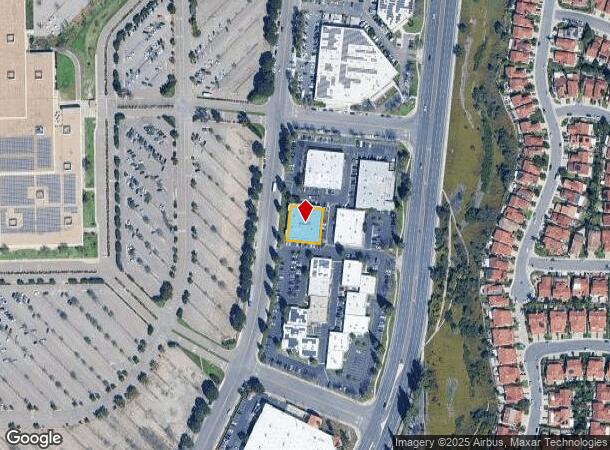
Property Record
27752 El Lazo, Laguna Niguel, CA 92677


Current Lease Availabilities
NEARBY LISTINGS FOR SALE OR LEASE
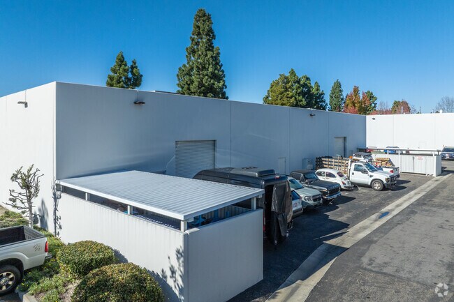
Property Detail
27752 El Lazo
Anaheim-Santa Ana-Irvine, CA
City/Laguna Niguel Prcl Map 81
634-061-17
P BK 161 PG 7 PAR 3
Industrialgeneral
Orange
X
California
06059C0437J
3
2024
0.28 AC
2025
Laguna Niguel/Laguna Beach
042320
Orange County (California)
11,637 SF
DEMOGRAPHICS near 27752 El Lazo
1 Mile
3 Mile
5 Mile
2024 Total Population
16,666
127,512
297,260
2029 Population
16,386
125,850
294,002
Pop Growth 2024-2029
(1.68%)
(1.30%)
(1.10%)
Average Age
41
42
44
2024 Total Households
6,621
48,496
114,739
HH Growth 2024-2029
(1.80%)
(1.38%)
(0.95%)
Median Household Inc
$119,236
$117,591
$116,222
Avg Household Size
2.50
2.60
2.50
2024 Avg HH Vehicles
2.00
2.00
2.00
Median Home Value
$786,359
$852,185
$857,082
Median Year Built
1989
1986
1983
Nearby Places
Map Layers
Map Styles
 Street
 Aerial
- Restaurants
- Banks
- Shops
- Fitness
- Groceries
PUBLIC TRANSPORTATION
COMMUTER RAIL
Laguna Niguel/Mission Viejo (Inland Empire-Orange County Line - Southern California Regional Rail Authority (Metrolink), Orange County Line - Southern California Regional Rail Authority (Metrolink))
DRIVE
WALK
Distance
Laguna Niguel/Mission Viejo (Inland Empire-Orange County Line - Southern California Regional Rail Authority (Metrolink), Orange County Line - Southern California Regional Rail Authority (Metrolink))
9 min
4.3 mi
San Juan Capistrano (Inland Empire-Orange County Line - Southern California Regional Rail Authority (Metrolink), Orange County Line - Southern California Regional Rail Authority (Metrolink))
DRIVE
WALK
Distance
San Juan Capistrano (Inland Empire-Orange County Line - Southern California Regional Rail Authority (Metrolink), Orange County Line - Southern California Regional Rail Authority (Metrolink))
12 min
8.0 mi
AIRPORT
John Wayne/Orange County
DRIVE
WALK
Distance
John Wayne/Orange County
21 min
15.4 mi
Long Beach (Daugherty Field)
DRIVE
WALK
Distance
Long Beach (Daugherty Field)
43 min
35.4 mi
Ontario International
DRIVE
WALK
Distance
Ontario International
63 min
46.8 mi
Freight Ports
Port of Long Beach
DRIVE
WALK
Distance
Port of Long Beach
47 min
34.9 mi
Nearby Properties
Address
Land Use
TOTAL SIZE
Lot Size
Zoning
Address
Land Use
TOTAL SIZE
Lot Size
Zoning
609,840 SF
28.33 AC
Address
Land Use
TOTAL SIZE
Lot Size
Zoning
104,707 SF
6.97 AC
RC
Address
Land Use
TOTAL SIZE
Lot Size
Zoning
Address
Land Use
TOTAL SIZE
Lot Size
Zoning
Address
Land Use
TOTAL SIZE
Lot Size
Zoning
602,904 SF
22.10 AC
Address
Land Use
TOTAL SIZE
Lot Size
Zoning
Address
Land Use
TOTAL SIZE
Lot Size
Zoning
Address
Land Use
TOTAL SIZE
Lot Size
Zoning
8.26 AC
Address
Land Use
TOTAL SIZE
Lot Size
Zoning
Address
Land Use
TOTAL SIZE
Lot Size
Zoning
Address
Land Use
TOTAL SIZE
Lot Size
Zoning
Address
Land Use
TOTAL SIZE
Lot Size
Zoning
Address
Land Use
TOTAL SIZE
Lot Size
Zoning
Address
Land Use
TOTAL SIZE
Lot Size
Zoning
Address
Land Use
TOTAL SIZE
Lot Size
Zoning
15.53 AC
Address
Land Use
TOTAL SIZE
Lot Size
Zoning
Address
Land Use
TOTAL SIZE
Lot Size
Zoning
13.70 AC
Address
Land Use
TOTAL SIZE
Lot Size
Zoning
Address
Land Use
TOTAL SIZE
Lot Size
Zoning
9.18 AC
Address
Land Use
TOTAL SIZE
Lot Size
Zoning
120,746 SF
1.17 AC
Address
Land Use
TOTAL SIZE
Lot Size
Zoning
Address
Land Use
TOTAL SIZE
Lot Size
Zoning
17.93 AC
Address
Land Use
TOTAL SIZE
Lot Size
Zoning
Address
Land Use
TOTAL SIZE
Lot Size
Zoning
5.13 AC
Address
Land Use
TOTAL SIZE
Lot Size
Zoning
2.81 AC
Address
Land Use
TOTAL SIZE
Lot Size
Zoning
Address
Land Use
TOTAL SIZE
Lot Size
Zoning
Address
Land Use
TOTAL SIZE
Lot Size
Zoning
Address
Land Use
TOTAL SIZE
Lot Size
Zoning
Address
Land Use
TOTAL SIZE
Lot Size
Zoning
245,482 SF
19.72 AC
The World's #1 Commercial Real Estate Marketplace
Connect with us
© 2025 CoStar Group
The information above has been obtained from sources believed reliable. While we do not doubt its accuracy we have not verified it and make no guarantee, warranty or representation about it. It is your responsibility to independently confirm its accuracy and completeness. Any projections, opinions, assumptions, or estimates used are for example only and do not represent the current or future performance of the property. The value of this transaction to you depends on tax and other factors which should be evaluated by your tax, financial, and legal advisors. You and your advisors should conduct a careful, independent investigation of the property to determine to your satisfaction the suitability of the property for your needs.