Property Record
2779 Nw Highway 70, Arcadia, FL 34266
NEARBY LISTINGS FOR SALE OR LEASE
-
-
View all Arcadia listings for sale on LoopNet.com
Property Detail
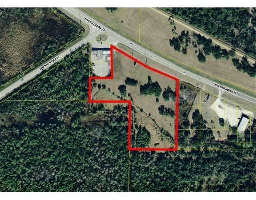
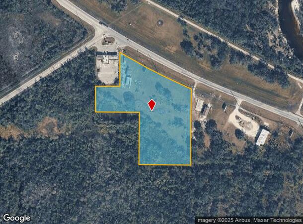
2779 Nw Highway 70
26-37-24-0000-0082-0000
THAT PART OF E1/2 OF SE1/4 OF NW1/4 OF SW1/4 LYG S OF NEW SR 70 & E OF SR 72 LESS BDRY TO PACEMASTER INC & ALSO THAT PART OF W1/2 OF SW1/4 OF NE1/4 SW1/4 LYG S OF NEW SR 70 & ALSO NW1/4 OF NW1/4 OF SE1/4 OF SW1/4 OR 590/1761,1762 INST:201614005108 IN
Commercialacreage
DeSoto
AE
Florida
12027C0157C
8 AC
2024
Florida Central South Area
2024
Other Market Areas
010302
Arcadia, FL
DEMOGRAPHICS near 2779 Nw Highway 70
1 Mile
3 Mile
5 Mile
2024 Total Population
350
15,637
23,233
2029 Population
383
17,341
25,600
Pop Growth 2024-2029
+ 9.43%
+ 10.90%
+ 10.19%
Average Age
39
38
40
2024 Total Households
134
5,447
8,301
HH Growth 2024-2029
+ 10.45%
+ 11.75%
+ 10.91%
Median Household Inc
$44,999
$29,795
$33,717
Avg Household Size
2.60
2.80
2.70
2024 Avg HH Vehicles
2.00
2.00
2.00
Median Home Value
$143,548
$126,681
$113,925
Median Year Built
1982
1980
1985
Nearby Places
Map Layers
Map Styles
 Street
 Aerial
- Restaurants
- Banks
- Shops
- Fitness
- Groceries
PUBLIC TRANSPORTATION
AIRPORT
Punta Gorda
DRIVE
WALK
Distance
Punta Gorda
40 min
26.9 mi
Freight Ports
Port Manatee
DRIVE
WALK
Distance
Port Manatee
75 min
56.0 mi
Nearby Properties
Address
Land Use
TOTAL SIZE
Lot Size
Zoning
Address
Land Use
TOTAL SIZE
Lot Size
Zoning
106,179 SF
12.48 AC
RPB
Address
Land Use
TOTAL SIZE
Lot Size
Zoning
182,809 SF
60 AC
A-5
Address
Land Use
TOTAL SIZE
Lot Size
Zoning
57,048 SF
20.25 AC
PUD
Address
Land Use
TOTAL SIZE
Lot Size
Zoning
223,038 SF
57 AC
IH
Address
Land Use
TOTAL SIZE
Lot Size
Zoning
121,889 SF
9 AC
B-3
Address
Land Use
TOTAL SIZE
Lot Size
Zoning
67,407 SF
4.82 AC
R-1B
Address
Land Use
TOTAL SIZE
Lot Size
Zoning
25,798 SF
5 AC
B-1A
Address
Land Use
TOTAL SIZE
Lot Size
Zoning
80,103 SF
11 AC
R-1B
Address
Land Use
TOTAL SIZE
Lot Size
Zoning
32,546 SF
45.40 AC
P/I
Address
Land Use
TOTAL SIZE
Lot Size
Zoning
53,740 SF
2.29 AC
R-1B
Address
Land Use
TOTAL SIZE
Lot Size
Zoning
45,985 SF
1.30 AC
B-2
Address
Land Use
TOTAL SIZE
Lot Size
Zoning
40,614 SF
4.33 AC
R-3
Address
Land Use
TOTAL SIZE
Lot Size
Zoning
41,004 SF
4.67 AC
R-3
Address
Land Use
TOTAL SIZE
Lot Size
Zoning
7,308 SF
48 AC
TTRVC
Address
Land Use
TOTAL SIZE
Lot Size
Zoning
54,644 SF
11.82 AC
PUD
Address
Land Use
TOTAL SIZE
Lot Size
Zoning
33.75 AC
PUD
Address
Land Use
TOTAL SIZE
Lot Size
Zoning
27,816 SF
3.67 AC
RMF-8
Address
Land Use
TOTAL SIZE
Lot Size
Zoning
48,488 SF
3.24 AC
B-2
Address
Land Use
TOTAL SIZE
Lot Size
Zoning
97,755 SF
9.20 AC
PUD
Address
Land Use
TOTAL SIZE
Lot Size
Zoning
8,016 SF
52.49 AC
RM
Address
Land Use
TOTAL SIZE
Lot Size
Zoning
32,256 SF
3.13 AC
R-4
Address
Land Use
TOTAL SIZE
Lot Size
Zoning
26,360 SF
1.80 AC
P-1
Address
Land Use
TOTAL SIZE
Lot Size
Zoning
59,064 SF
7 AC
RSF-3
Address
Land Use
TOTAL SIZE
Lot Size
Zoning
34,600 SF
4.85 AC
RPB
Address
Land Use
TOTAL SIZE
Lot Size
Zoning
66,888 SF
11.95 AC
RMF-12
Address
Land Use
TOTAL SIZE
Lot Size
Zoning
36,686 SF
3.88 AC
PUD
Address
Land Use
TOTAL SIZE
Lot Size
Zoning
25,790 SF
2.47 AC
R-1B
Address
Land Use
TOTAL SIZE
Lot Size
Zoning
28,744 SF
2.94 AC
B-1A
Address
Land Use
TOTAL SIZE
Lot Size
Zoning
39,000 SF
3.43 AC
B-3
Address
Land Use
TOTAL SIZE
Lot Size
Zoning
32,087 SF
2.54 AC
R-1B
The World's #1 Commercial Real Estate Marketplace
Connect with us
© 2025 CoStar Group
The information above has been obtained from sources believed reliable. While we do not doubt its accuracy we have not verified it and make no guarantee, warranty or representation about it. It is your responsibility to independently confirm its accuracy and completeness. Any projections, opinions, assumptions, or estimates used are for example only and do not represent the current or future performance of the property. The value of this transaction to you depends on tax and other factors which should be evaluated by your tax, financial, and legal advisors. You and your advisors should conduct a careful, independent investigation of the property to determine to your satisfaction the suitability of the property for your needs.