Property Record
2780 River Rd, Vandergrift, PA 15690
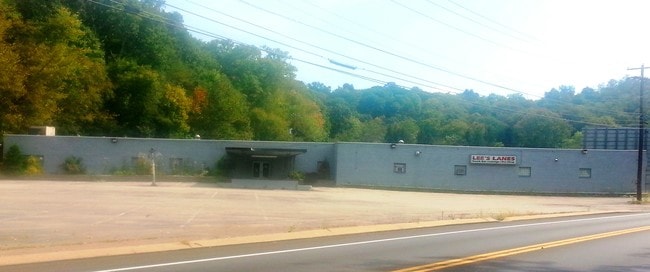

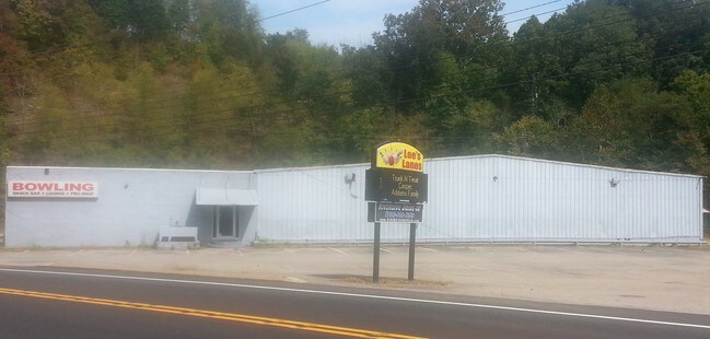
Property Detail
2780 River Rd
35-0-052168
MAP NO:215.00-01-58.001- ; 4.733A - IMPRS
Storebuilding
Armstrong
AE The base floodplain where base flood elevations are provided. AE Zones are now used on new format FIRMs instead of A1-A30 Zones.
Pennsylvania
2025
4.64 AC
2025
Armstrong County
951400
Pittsburgh
29,315 SF
Pittsburgh, PA
NEARBY LISTINGS FOR SALE OR LEASE
DEMOGRAPHICS near 2780 River Rd
1 mile
3 mile
5 mile
2025 Total Population
1,492
20,722
29,983
2030 Population
1,462
20,498
29,571
Pop Growth 2025-2030
(2.01%)
(1.08%)
(1.37%)
Average Age
43
43
45
2025 Total Households
632
9,010
12,924
HH Growth 2025-2030
(1.90%)
(1.13%)
(1.42%)
Median Household Inc
$61,500
$59,069
$63,837
Avg Household Size
2.30
2.30
2.30
2025 Avg HH Vehicles
2.00
2.00
2.00
Median Home Value
$134,708
$134,109
$152,643
Median Year Built
1953
1952
1957
Nearby Places
Map Layers
Map Styles
 Street
 Aerial
Transit
 Traffic
 Biking
Places
Listings with unknown addresses are not visible on the map
- Restaurants
- Banks
- Shops
- Fitness
- Groceries
PUBLIC TRANSPORTATION
AIRPORT
Arnold Palmer Regional
Drive
Walk
Distance
Arnold Palmer Regional
59 min
34.0 mi
Freight Ports
Port of Baltimore
Drive
Walk
Distance
Port of Baltimore
297 min
247.6 mi
SALE & LEASE HISTORY
LISTING DATE
SALE/LEASE

Sep 28, 2017
For Sale
Dec 27, 2017
For Sale
Nearby Properties
Address
Land Use
TOTAL SIZE
Lot Size
Zoning
Address
Land Use
TOTAL SIZE
Lot Size
Zoning
98.20 AC
Address
Land Use
TOTAL SIZE
Lot Size
Zoning
120,681 SF
2.97 AC
RESIDENTIA
Address
Land Use
TOTAL SIZE
Lot Size
Zoning
81,195 SF
7.65 AC
Address
Land Use
TOTAL SIZE
Lot Size
Zoning
64.20 AC
Address
Land Use
TOTAL SIZE
Lot Size
Zoning
0.43 AC
Address
Land Use
TOTAL SIZE
Lot Size
Zoning
14.10 AC
Address
Land Use
TOTAL SIZE
Lot Size
Zoning
77,590 SF
10.53 AC
Address
Land Use
TOTAL SIZE
Lot Size
Zoning
48,148 SF
5.27 AC
Address
Land Use
TOTAL SIZE
Lot Size
Zoning
23,088 SF
1.54 AC
RESIDENTIA
Address
Land Use
TOTAL SIZE
Lot Size
Zoning
9.07 AC
Address
Land Use
TOTAL SIZE
Lot Size
Zoning
140.40 AC
Address
Land Use
TOTAL SIZE
Lot Size
Zoning
69,000 SF
7.09 AC
Address
Land Use
TOTAL SIZE
Lot Size
Zoning
44,062 SF
1.14 AC
LIGHT INDU
Address
Land Use
TOTAL SIZE
Lot Size
Zoning
36,928 SF
37.75 AC
Address
Land Use
TOTAL SIZE
Lot Size
Zoning
44,550 SF
0.33 AC
BUSINESS
Address
Land Use
TOTAL SIZE
Lot Size
Zoning
6,312 SF
3.46 AC
Address
Land Use
TOTAL SIZE
Lot Size
Zoning
Address
Land Use
TOTAL SIZE
Lot Size
Zoning
19,701 SF
0.37 AC
RESIDENTIA
Address
Land Use
TOTAL SIZE
Lot Size
Zoning
19,150 SF
6.26 AC
RESIDENTIA
Address
Land Use
TOTAL SIZE
Lot Size
Zoning
9.60 AC
Address
Land Use
TOTAL SIZE
Lot Size
Zoning
1,848 SF
5.32 AC
Address
Land Use
TOTAL SIZE
Lot Size
Zoning
28,600 SF
6.56 AC
Address
Land Use
TOTAL SIZE
Lot Size
Zoning
13,050 SF
Address
Land Use
TOTAL SIZE
Lot Size
Zoning
11,485 SF
2.42 AC
Address
Land Use
TOTAL SIZE
Lot Size
Zoning
Address
Land Use
TOTAL SIZE
Lot Size
Zoning
17,440 SF
2.57 AC
Address
Land Use
TOTAL SIZE
Lot Size
Zoning
17,225 SF
0.45 AC
BUSINESS
Address
Land Use
TOTAL SIZE
Lot Size
Zoning
16,419 SF
0.35 AC
BUSINESS
Address
Land Use
TOTAL SIZE
Lot Size
Zoning
25,456 SF
2.51 AC
Address
Land Use
TOTAL SIZE
Lot Size
Zoning
41,596 SF
0.32 AC
RESIDENTIA
The World's #1 Commercial Real Estate Marketplace
Connect with us
© 2026 CoStar Group
The information above has been obtained from sources believed reliable. While we do not doubt its accuracy we have not verified it and make no guarantee, warranty or representation about it. It is your responsibility to independently confirm its accuracy and completeness. Any projections, opinions, assumptions, or estimates used are for example only and do not represent the current or future performance of the property. The value of this transaction to you depends on tax and other factors which should be evaluated by your tax, financial, and legal advisors. You and your advisors should conduct a careful, independent investigation of the property to determine to your satisfaction the suitability of the property for your needs.