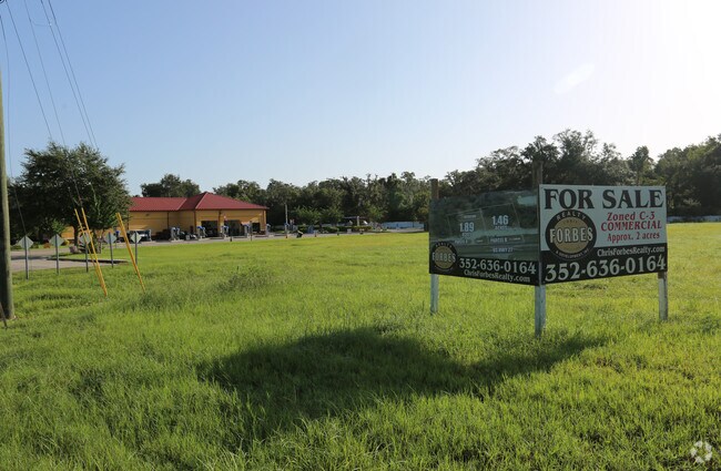
Property Record
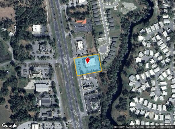
27800 Us Highway 27, Leesburg, FL 34748


NEARBY LISTINGS FOR SALE OR LEASE
Property Detail
27800 Us Highway 27
Orlando-Kissimmee-Sanford, FL
Acreage
14-20-24-0001-000-00700
SLY 212 FT OF THE FOLLOWING DESCRIBED PROPERTY: FROM NW COR OF NE 1/4 RUN S 89-26-46 E ALONG SAID N LINE 474.06 FT TO ELY R/W LINE OF US HWY 27 S 11-0-0 E ALONG SAID ELY R/W LINE 25.40 FT TO S R/W LINE OF COMMANDER RD & POB CONT S 11-0-0 E ALONG ELY
Departmentstore
Lake
X
Florida
12069C0320E
7
2024
1.45 AC
2026
Lake County
031104
Orlando
10,320 SF
DEMOGRAPHICS near 27800 Us Highway 27
1 Mile
3 Mile
5 Mile
2024 Total Population
4,268
17,397
38,416
2029 Population
4,990
20,478
45,252
Pop Growth 2024-2029
+ 16.92%
+ 17.71%
+ 17.79%
Average Age
67
62
53
2024 Total Households
2,346
9,009
18,192
HH Growth 2024-2029
+ 16.84%
+ 17.46%
+ 17.69%
Median Household Inc
$54,207
$62,867
$56,181
Avg Household Size
1.80
1.90
2.10
2024 Avg HH Vehicles
1.00
1.00
1.00
Median Home Value
$128,214
$222,523
$212,822
Median Year Built
1986
1995
1991
Nearby Places
Map Layers
Map Styles
 Street
 Aerial
- Restaurants
- Banks
- Shops
- Fitness
- Groceries
PUBLIC TRANSPORTATION
AIRPORT
Orlando International
DRIVE
WALK
Distance
Orlando International
63 min
49.5 mi
SALE & LEASE HISTORY
LISTING DATE
SALE/LEASE

Sep 24, 2016
For Sale
Sep 01, 2017
For Sale
Nearby Properties
Address
Land Use
TOTAL SIZE
Lot Size
Zoning
Address
Land Use
TOTAL SIZE
Lot Size
Zoning
36,358 SF
276.18 AC
RMRP
Address
Land Use
TOTAL SIZE
Lot Size
Zoning
73,144 SF
75 AC
Address
Land Use
TOTAL SIZE
Lot Size
Zoning
46,020 SF
6.11 AC
Address
Land Use
TOTAL SIZE
Lot Size
Zoning
79,305 SF
17.45 AC
C3
Address
Land Use
TOTAL SIZE
Lot Size
Zoning
96,507 SF
3.45 AC
C1
Address
Land Use
TOTAL SIZE
Lot Size
Zoning
154,635 SF
11.75 AC
C3
Address
Land Use
TOTAL SIZE
Lot Size
Zoning
61,743 SF
9.79 AC
C3
Address
Land Use
TOTAL SIZE
Lot Size
Zoning
74,035 SF
6.34 AC
M1
Address
Land Use
TOTAL SIZE
Lot Size
Zoning
60,603 SF
8.40 AC
C3
Address
Land Use
TOTAL SIZE
Lot Size
Zoning
81,060 SF
8.66 AC
C2
Address
Land Use
TOTAL SIZE
Lot Size
Zoning
123,990 SF
19.68 AC
MP
Address
Land Use
TOTAL SIZE
Lot Size
Zoning
2,000 SF
164.87 AC
CFD
Address
Land Use
TOTAL SIZE
Lot Size
Zoning
36,954 SF
5.78 AC
PUD
Address
Land Use
TOTAL SIZE
Lot Size
Zoning
96,236 SF
9.79 AC
HM
Address
Land Use
TOTAL SIZE
Lot Size
Zoning
96.69 AC
CFD
Address
Land Use
TOTAL SIZE
Lot Size
Zoning
4,888 SF
3.98 AC
RMRP
Address
Land Use
TOTAL SIZE
Lot Size
Zoning
53,597 SF
3.96 AC
C1
Address
Land Use
TOTAL SIZE
Lot Size
Zoning
30,069 SF
6.50 AC
MP
Address
Land Use
TOTAL SIZE
Lot Size
Zoning
57.42 AC
HM
Address
Land Use
TOTAL SIZE
Lot Size
Zoning
14,313 SF
2.55 AC
C3
Address
Land Use
TOTAL SIZE
Lot Size
Zoning
23,449 SF
3.20 AC
C3
Address
Land Use
TOTAL SIZE
Lot Size
Zoning
52,020 SF
6 AC
LM
Address
Land Use
TOTAL SIZE
Lot Size
Zoning
17,231 SF
2.24 AC
PUD
Address
Land Use
TOTAL SIZE
Lot Size
Zoning
77.32 AC
Address
Land Use
TOTAL SIZE
Lot Size
Zoning
2,000 SF
40 AC
CFD
Address
Land Use
TOTAL SIZE
Lot Size
Zoning
14,430 SF
2.64 AC
CP
Address
Land Use
TOTAL SIZE
Lot Size
Zoning
20,260 SF
3.36 AC
R1
Address
Land Use
TOTAL SIZE
Lot Size
Zoning
14,820 SF
3.50 AC
Address
Land Use
TOTAL SIZE
Lot Size
Zoning
24,837 SF
10.16 AC
HM
Address
Land Use
TOTAL SIZE
Lot Size
Zoning
3,815 SF
1.52 AC
C3
The World's #1 Commercial Real Estate Marketplace
Connect with us
© 2025 CoStar Group
The information above has been obtained from sources believed reliable. While we do not doubt its accuracy we have not verified it and make no guarantee, warranty or representation about it. It is your responsibility to independently confirm its accuracy and completeness. Any projections, opinions, assumptions, or estimates used are for example only and do not represent the current or future performance of the property. The value of this transaction to you depends on tax and other factors which should be evaluated by your tax, financial, and legal advisors. You and your advisors should conduct a careful, independent investigation of the property to determine to your satisfaction the suitability of the property for your needs.