Property Record
2787 Center Rd, Moriah, NY 12960


NEARBY LISTINGS FOR SALE OR LEASE
-
-
View all Moriah listings for sale on LoopNet.com
Property Detail
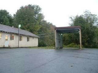
2787 Center Rd
Other Market Areas
23 SMALLS
153689-096-051-0001-013-000-0000
Essex
Storesoffices
New York
2025
13.000
2024
1.30 AC
961001
Upstate New York Area
2,858 SF
DEMOGRAPHICS near 2787 Center Rd
1 Mile
3 Mile
5 Mile
2024 Total Population
328
3,730
4,450
2029 Population
309
3,590
4,293
Pop Growth 2024-2029
(5.79%)
(3.75%)
(3.53%)
Average Age
42
43
43
2024 Total Households
137
1,527
1,800
HH Growth 2024-2029
(5.84%)
(3.93%)
(3.72%)
Median Household Inc
$42,777
$40,941
$42,893
Avg Household Size
2.40
2.30
2.30
2024 Avg HH Vehicles
1.00
2.00
2.00
Median Home Value
$151,562
$128,939
$131,909
Median Year Built
1966
1962
1963
Nearby Places
Map Layers
Map Styles
 Street
 Aerial
- Restaurants
- Banks
- Shops
- Fitness
- Groceries
PUBLIC TRANSPORTATION
COMMUTER RAIL
Port Henry Amtrak Station (Adirondack - Amtrak)
DRIVE
WALK
Distance
Port Henry Amtrak Station (Adirondack - Amtrak)
8 min
3.5 mi
Freight Ports
Albany, NY Port
DRIVE
WALK
Distance
Albany, NY Port
146 min
117.7 mi
Nearby Properties
Address
Land Use
TOTAL SIZE
Lot Size
Zoning
Address
Land Use
TOTAL SIZE
Lot Size
Zoning
155,079 SF
61.50 AC
07 - MIXED
Address
Land Use
TOTAL SIZE
Lot Size
Zoning
5,759 SF
3.25 AC
07 - MIXED
Address
Land Use
TOTAL SIZE
Lot Size
Zoning
3,344 SF
6 AC
07 - MIXED
Address
Land Use
TOTAL SIZE
Lot Size
Zoning
29,670 SF
1.54 AC
07 - MIXED
Address
Land Use
TOTAL SIZE
Lot Size
Zoning
16,260 SF
8.20 AC
07 - MIXED
Address
Land Use
TOTAL SIZE
Lot Size
Zoning
54,882 SF
18.50 AC
07 - MIXED
Address
Land Use
TOTAL SIZE
Lot Size
Zoning
14,000 SF
4.51 AC
07 - MIXED
Address
Land Use
TOTAL SIZE
Lot Size
Zoning
1,872 SF
13.20 AC
05 - COMME
Address
Land Use
TOTAL SIZE
Lot Size
Zoning
16,798 SF
2.90 AC
05 - COMME
Address
Land Use
TOTAL SIZE
Lot Size
Zoning
4,529 SF
2.69 AC
07 - MIXED
Address
Land Use
TOTAL SIZE
Lot Size
Zoning
6,912 SF
3.50 AC
05 - COMME
Address
Land Use
TOTAL SIZE
Lot Size
Zoning
10,640 SF
2.14 AC
01 - NOT Z
Address
Land Use
TOTAL SIZE
Lot Size
Zoning
170.10 AC
06 - INDUS
Address
Land Use
TOTAL SIZE
Lot Size
Zoning
4,032 SF
1.27 AC
07 - MIXED
Address
Land Use
TOTAL SIZE
Lot Size
Zoning
10,010 SF
1.20 AC
07 - MIXED
Address
Land Use
TOTAL SIZE
Lot Size
Zoning
15 AC
07 - MIXED
Address
Land Use
TOTAL SIZE
Lot Size
Zoning
1,531.70 AC
02 - SINGL
Address
Land Use
TOTAL SIZE
Lot Size
Zoning
5,940 SF
3.40 AC
05 - COMME
Address
Land Use
TOTAL SIZE
Lot Size
Zoning
5,042 SF
10.10 AC
06 - INDUS
Address
Land Use
TOTAL SIZE
Lot Size
Zoning
12,206 SF
0.40 AC
05 - COMME
Address
Land Use
TOTAL SIZE
Lot Size
Zoning
3,034 SF
0.78 AC
07 - MIXED
Address
Land Use
TOTAL SIZE
Lot Size
Zoning
22,000 SF
4.38 AC
07 - MIXED
Address
Land Use
TOTAL SIZE
Lot Size
Zoning
1.20 AC
07 - MIXED
Address
Land Use
TOTAL SIZE
Lot Size
Zoning
14,000 SF
2.41 AC
07 - MIXED
Address
Land Use
TOTAL SIZE
Lot Size
Zoning
4,911 SF
21.80 AC
07 - MIXED
Address
Land Use
TOTAL SIZE
Lot Size
Zoning
6,800 SF
33.05 AC
07 - MIXED
Address
Land Use
TOTAL SIZE
Lot Size
Zoning
1,849 SF
0.10 AC
05 - COMME
Address
Land Use
TOTAL SIZE
Lot Size
Zoning
1,664 SF
10.07 AC
05 - COMME
Address
Land Use
TOTAL SIZE
Lot Size
Zoning
3,000 SF
0.56 AC
05 - COMME
Address
Land Use
TOTAL SIZE
Lot Size
Zoning
962 SF
81.77 AC
02 - SINGL
The World's #1 Commercial Real Estate Marketplace
Connect with us
© 2026 CoStar Group
The information above has been obtained from sources believed reliable. While we do not doubt its accuracy we have not verified it and make no guarantee, warranty or representation about it. It is your responsibility to independently confirm its accuracy and completeness. Any projections, opinions, assumptions, or estimates used are for example only and do not represent the current or future performance of the property. The value of this transaction to you depends on tax and other factors which should be evaluated by your tax, financial, and legal advisors. You and your advisors should conduct a careful, independent investigation of the property to determine to your satisfaction the suitability of the property for your needs.