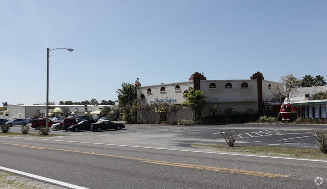
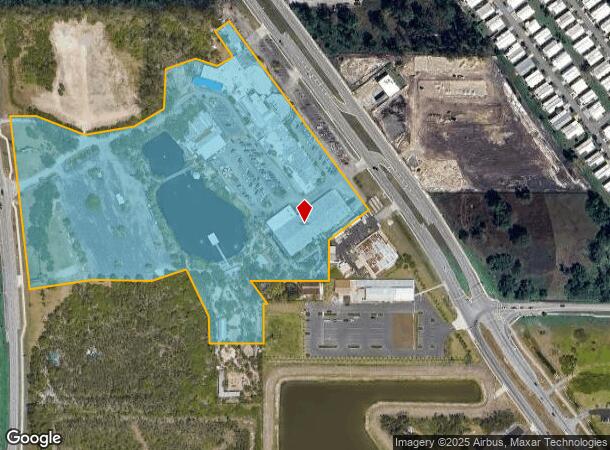
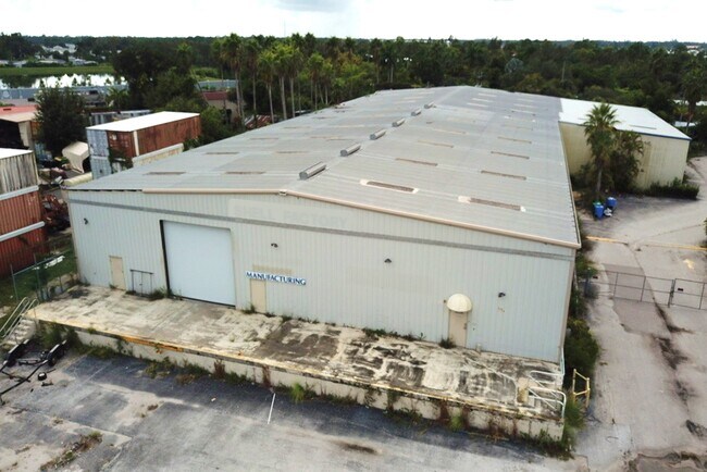
Property Record
2787/2751 N Tamiami Trl, North Fort Myers, FL 33903
Current Lease Availabilities
NEARBY LISTINGS FOR SALE OR LEASE
Property Detail
2787/2751 N Tamiami Trl
27-43-24-00-00009.0000
N. 41 Corridor Large Bb
Amusementpark
PARL IN NE1/4 DESC MISC BOOK 33/429 + DEED BOOK 227/482 + 2013/2413 + PORT DESC IN INST #2010000256675
A
Lee
12071C0259G
Florida
2024
15.05 AC
2025
North Ft Myers
020600
Southwest Florida
122,864 SF
Cape Coral-Fort Myers, FL
DEMOGRAPHICS near 2787/2751 N Tamiami Trl
1 Mile
3 Mile
5 Mile
2024 Total Population
6,368
45,697
105,070
2029 Population
7,534
54,502
125,150
Pop Growth 2024-2029
+ 18.31%
+ 19.27%
+ 19.11%
Average Age
58
51
48
2024 Total Households
3,379
21,315
45,819
HH Growth 2024-2029
+ 17.85%
+ 18.69%
+ 18.72%
Median Household Inc
$39,151
$46,321
$55,251
Avg Household Size
1.90
2.10
2.20
2024 Avg HH Vehicles
1.00
1.00
2.00
Median Home Value
$62,196
$116,502
$198,883
Median Year Built
1981
1985
1989
Nearby Places
- Restaurants
- Banks
- Shops
- Fitness
- Groceries
PUBLIC TRANSPORTATION
AIRPORT
Southwest Florida International
DRIVE
WALK
Distance
Southwest Florida International
30 min
18.4 mi
Punta Gorda
DRIVE
WALK
Distance
Punta Gorda
26 min
18.5 mi
Freight Ports
Port Manatee
DRIVE
WALK
Distance
Port Manatee
106 min
90.1 mi
Nearby Properties
Address
Land Use
TOTAL SIZE
Lot Size
Zoning
Address
Land Use
TOTAL SIZE
Lot Size
Zoning
214,515 SF
30.60 AC
I-1
Address
Land Use
TOTAL SIZE
Lot Size
Zoning
485,271 SF
20.05 AC
CORR
Address
Land Use
TOTAL SIZE
Lot Size
Zoning
347,871 SF
29.40 AC
RML
Address
Land Use
TOTAL SIZE
Lot Size
Zoning
13.60 AC
CC
Address
Land Use
TOTAL SIZE
Lot Size
Zoning
262,258 SF
52.71 AC
INS
Address
Land Use
TOTAL SIZE
Lot Size
Zoning
138,476 SF
4.11 AC
CORR
Address
Land Use
TOTAL SIZE
Lot Size
Zoning
451,348 SF
21.43 AC
CPD
Address
Land Use
TOTAL SIZE
Lot Size
Zoning
209,881 SF
63.03 AC
AG-2
Address
Land Use
TOTAL SIZE
Lot Size
Zoning
1,666 SF
35.55 AC
AG-2
Address
Land Use
TOTAL SIZE
Lot Size
Zoning
82,478 SF
15.46 AC
CORR
Address
Land Use
TOTAL SIZE
Lot Size
Zoning
212,616 SF
6.61 AC
CORR/CPO
Address
Land Use
TOTAL SIZE
Lot Size
Zoning
112,356 SF
18.99 AC
AG-2
Address
Land Use
TOTAL SIZE
Lot Size
Zoning
109,404 SF
14.22 AC
AG-2
Address
Land Use
TOTAL SIZE
Lot Size
Zoning
51,478 SF
68.97 AC
C-2
Address
Land Use
TOTAL SIZE
Lot Size
Zoning
107,321 SF
7.80 AC
C-1A
Address
Land Use
TOTAL SIZE
Lot Size
Zoning
101,343 SF
8.06 AC
IL
Address
Land Use
TOTAL SIZE
Lot Size
Zoning
141,571 SF
4.57 AC
C-1A
Address
Land Use
TOTAL SIZE
Lot Size
Zoning
222,159 SF
25.12 AC
CP-D
Address
Land Use
TOTAL SIZE
Lot Size
Zoning
81,160 SF
9.40 AC
CPD
Address
Land Use
TOTAL SIZE
Lot Size
Zoning
79,253 SF
11.47 AC
C-3
Address
Land Use
TOTAL SIZE
Lot Size
Zoning
72,683 SF
9.82 AC
CPD
Address
Land Use
TOTAL SIZE
Lot Size
Zoning
48,780 SF
14.99 AC
Address
Land Use
TOTAL SIZE
Lot Size
Zoning
53,781 SF
6.84 AC
CPO
Address
Land Use
TOTAL SIZE
Lot Size
Zoning
85,915 SF
9.33 AC
CC
Address
Land Use
TOTAL SIZE
Lot Size
Zoning
59,736 SF
14.91 AC
C-2
Address
Land Use
TOTAL SIZE
Lot Size
Zoning
145,734 SF
13.20 AC
C-1A
Address
Land Use
TOTAL SIZE
Lot Size
Zoning
90 AC
C-2
Address
Land Use
TOTAL SIZE
Lot Size
Zoning
29,909 SF
3.47 AC
AG-2
Address
Land Use
TOTAL SIZE
Lot Size
Zoning
106,615 SF
4.51 AC
C1-A
Address
Land Use
TOTAL SIZE
Lot Size
Zoning
106.20 AC
RPD
The World's #1 Commercial Real Estate Marketplace
Connect with us
© 2025 CoStar Group
The information above has been obtained from sources believed reliable. While we do not doubt its accuracy we have not verified it and make no guarantee, warranty or representation about it. It is your responsibility to independently confirm its accuracy and completeness. Any projections, opinions, assumptions, or estimates used are for example only and do not represent the current or future performance of the property. The value of this transaction to you depends on tax and other factors which should be evaluated by your tax, financial, and legal advisors. You and your advisors should conduct a careful, independent investigation of the property to determine to your satisfaction the suitability of the property for your needs.