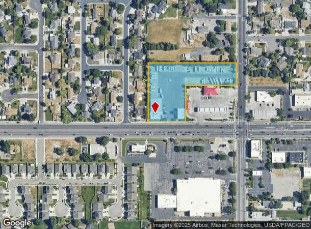
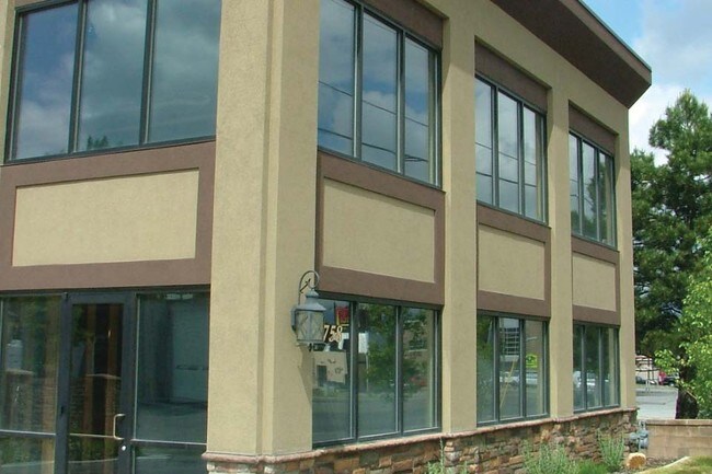
Property Record
2790 W 7800 S, West Jordan, UT 84088

NEARBY LISTINGS FOR SALE OR LEASE
Property Detail
2790 W 7800 S
21-28-378-042-0000
BEG S 895759 W 330.43 FT & N 00201 W 53 FT FR S 1/4 COR SEC 28, T2S, R1W, SLM; S 895759 W 220.26 FT; N 00126 W 342.53 FT; N 895810 E 517.72 FT; S 00115 E 131.83 FT; S 895845 W 297.49 FT; S 00201 E 210.73 FT TO BEG. 2.63 AC M OR L. 8544-1387,1389 8742
Officebuilding
Salt Lake
X
Utah
49035C0427G
2.63 AC
2024
Southwest Valley
2025
Salt Lake City
112921
Salt Lake City-Murray, UT
9,640 SF
DEMOGRAPHICS near 2790 W 7800 S
1 Mile
3 Mile
5 Mile
2024 Total Population
16,651
129,475
378,833
2029 Population
16,662
131,272
384,992
Pop Growth 2024-2029
+ 0.07%
+ 1.39%
+ 1.63%
Average Age
37
37
36
2024 Total Households
5,024
41,258
120,990
HH Growth 2024-2029
(0.02%)
+ 1.35%
+ 1.58%
Median Household Inc
$93,019
$85,073
$84,738
Avg Household Size
3.20
3.00
3.00
2024 Avg HH Vehicles
2.00
2.00
2.00
Median Home Value
$388,529
$412,039
$410,522
Median Year Built
1984
1991
1991
Nearby Places
Map Layers
Map Styles
 Street
 Aerial
- Restaurants
- Banks
- Shops
- Fitness
- Groceries
PUBLIC TRANSPORTATION
TRANSIT/SUBWAY
2700 W. Sugar Factory Rd Station (Red Line - Utah Transit Authority (UTA))
DRIVE
WALK
Distance
2700 W. Sugar Factory Rd Station (Red Line - Utah Transit Authority (UTA))
2 min
16 min
0.9 mi
COMMUTER RAIL
South Jordan Station (FrontRunner - Utah Transit Authority (UTA))
DRIVE
WALK
Distance
South Jordan Station (FrontRunner - Utah Transit Authority (UTA))
12 min
6.1 mi
AIRPORT
Salt Lake City International
DRIVE
WALK
Distance
Salt Lake City International
20 min
13.2 mi
Freight Ports
Port of Stockton
DRIVE
WALK
Distance
Port of Stockton
721 min
699.8 mi
SALE & LEASE HISTORY
LISTING DATE
SALE/LEASE

Sep 25, 2016
For Lease
Nearby Properties
Address
Land Use
TOTAL SIZE
Lot Size
Zoning
Address
Land Use
TOTAL SIZE
Lot Size
Zoning
895,175 SF
28.95 AC
SSD-X
Address
Land Use
TOTAL SIZE
Lot Size
Zoning
198,801 SF
8.36 AC
R-3-20
Address
Land Use
TOTAL SIZE
Lot Size
Zoning
427,884 SF
18.22 AC
JB-4
Address
Land Use
TOTAL SIZE
Lot Size
Zoning
187.81 AC
P-F
Address
Land Use
TOTAL SIZE
Lot Size
Zoning
497,522 SF
16.43 AC
MH
Address
Land Use
TOTAL SIZE
Lot Size
Zoning
679,800 SF
18.14 AC
BJ-1-3
Address
Land Use
TOTAL SIZE
Lot Size
Zoning
448,232 SF
9.08 AC
PC
Address
Land Use
TOTAL SIZE
Lot Size
Zoning
74,120 SF
12.61 AC
BJ
Address
Land Use
TOTAL SIZE
Lot Size
Zoning
123,864 SF
6.75 AC
C-2
Address
Land Use
TOTAL SIZE
Lot Size
Zoning
321,397 SF
11.16 AC
BJ
Address
Land Use
TOTAL SIZE
Lot Size
Zoning
410,435 SF
2.43 AC
P-C
Address
Land Use
TOTAL SIZE
Lot Size
Zoning
77,525 SF
2.35 AC
P-C
Address
Land Use
TOTAL SIZE
Lot Size
Zoning
45,924 SF
18.15 AC
R-3-20
Address
Land Use
TOTAL SIZE
Lot Size
Zoning
114.79 AC
PF
Address
Land Use
TOTAL SIZE
Lot Size
Zoning
143,314 SF
2.30 AC
P-C
Address
Land Use
TOTAL SIZE
Lot Size
Zoning
289,838 SF
24.11 AC
BJ-3
Address
Land Use
TOTAL SIZE
Lot Size
Zoning
117,521 SF
57.92 AC
PF
Address
Land Use
TOTAL SIZE
Lot Size
Zoning
28,515 SF
6.77 AC
PC
Address
Land Use
TOTAL SIZE
Lot Size
Zoning
40,042 SF
15.43 AC
R-3-16
Address
Land Use
TOTAL SIZE
Lot Size
Zoning
203,064 SF
5.91 AC
PC
Address
Land Use
TOTAL SIZE
Lot Size
Zoning
120,929 SF
7.23 AC
PC
Address
Land Use
TOTAL SIZE
Lot Size
Zoning
174,582 SF
18.60 AC
BJ
Address
Land Use
TOTAL SIZE
Lot Size
Zoning
76,837 SF
50.54 AC
P-F
Address
Land Use
TOTAL SIZE
Lot Size
Zoning
268,200 SF
44.38 AC
PF
Address
Land Use
TOTAL SIZE
Lot Size
Zoning
36,708 SF
12.83 AC
R-3-16
Address
Land Use
TOTAL SIZE
Lot Size
Zoning
209,880 SF
5.62 AC
BJ
Address
Land Use
TOTAL SIZE
Lot Size
Zoning
314,994 SF
10 AC
R-3
Address
Land Use
TOTAL SIZE
Lot Size
Zoning
105,956 SF
37.60 AC
4180
Address
Land Use
TOTAL SIZE
Lot Size
Zoning
66,211 SF
9.12 AC
BJ
Address
Land Use
TOTAL SIZE
Lot Size
Zoning
80 AC
PF
The World's #1 Commercial Real Estate Marketplace
Connect with us
© 2026 CoStar Group
The information above has been obtained from sources believed reliable. While we do not doubt its accuracy we have not verified it and make no guarantee, warranty or representation about it. It is your responsibility to independently confirm its accuracy and completeness. Any projections, opinions, assumptions, or estimates used are for example only and do not represent the current or future performance of the property. The value of this transaction to you depends on tax and other factors which should be evaluated by your tax, financial, and legal advisors. You and your advisors should conduct a careful, independent investigation of the property to determine to your satisfaction the suitability of the property for your needs.