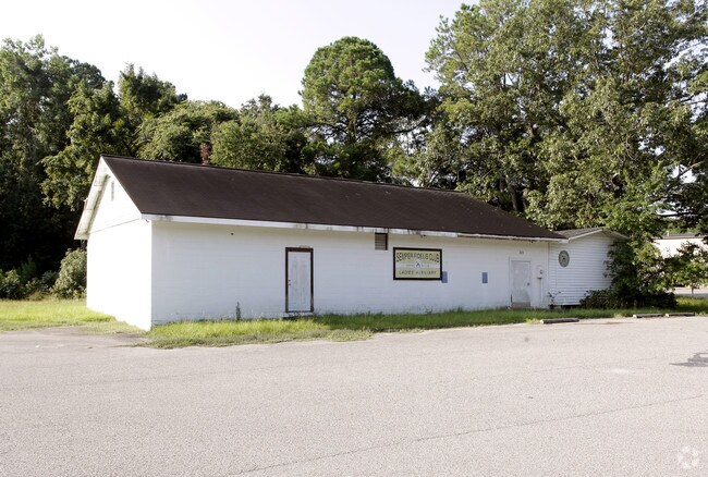
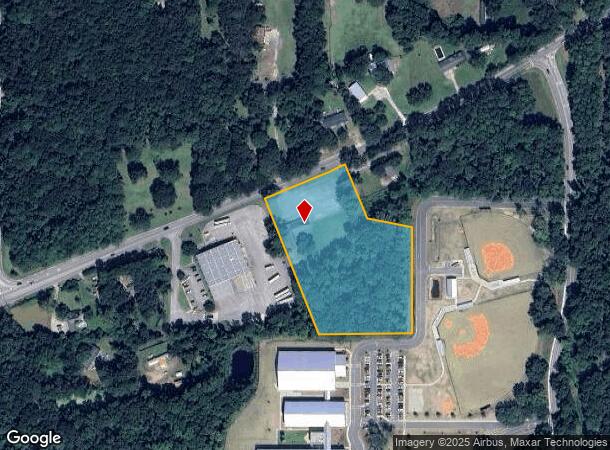
Property Record
279 Broad River Blvd, Beaufort, SC 29906
NEARBY LISTINGS FOR SALE OR LEASE
-
-
-
No Photo
-
View all Beaufort listings for sale on LoopNet.com
Property Detail
279 Broad River Blvd
Other Market Areas
Burton Commercial & Mixed Use
Hilton Head Island-Bluffton-Beaufort, SC
POR LOT 61 SEC 3 1S2W PLAT IN DB124 P230
R100-028-000-136B-0000
Beaufort
Nurserygreenhouseflorist
South Carolina
2025
61
2024
4.14 AC
000501
Hilton Head/Beaufort
4,225 SF
DEMOGRAPHICS near 279 Broad River Blvd
1 Mile
3 Mile
5 Mile
2024 Total Population
2,271
20,716
41,705
2029 Population
2,494
23,014
46,086
Pop Growth 2024-2029
+ 9.82%
+ 11.09%
+ 10.50%
Average Age
34
38
38
2024 Total Households
830
8,150
16,114
HH Growth 2024-2029
+ 9.40%
+ 10.70%
+ 10.51%
Median Household Inc
$44,291
$57,181
$57,115
Avg Household Size
2.70
2.50
2.40
2024 Avg HH Vehicles
2.00
2.00
2.00
Median Home Value
$171,317
$246,650
$258,044
Median Year Built
1992
1995
1990
Nearby Places
Map Layers
Map Styles
 Street
 Aerial
- Restaurants
- Banks
- Shops
- Fitness
- Groceries
PUBLIC TRANSPORTATION
AIRPORT
Savannah/Hilton Head International
DRIVE
WALK
Distance
Savannah/Hilton Head International
47 min
43.7 mi
SALE & LEASE HISTORY
LISTING DATE
SALE/LEASE

Sep 24, 2016
For Sale
Nearby Properties
Address
Land Use
TOTAL SIZE
Lot Size
Zoning
Address
Land Use
TOTAL SIZE
Lot Size
Zoning
4,613 AC
6601
Address
Land Use
TOTAL SIZE
Lot Size
Zoning
243,644 SF
13.23 AC
6601
Address
Land Use
TOTAL SIZE
Lot Size
Zoning
426,516 SF
32.63 AC
6601
Address
Land Use
TOTAL SIZE
Lot Size
Zoning
1,802 SF
21.42 AC
6111
Address
Land Use
TOTAL SIZE
Lot Size
Zoning
22,944 SF
16.59 AC
6101
Address
Land Use
TOTAL SIZE
Lot Size
Zoning
23,136 SF
9.67 AC
6101
Address
Land Use
TOTAL SIZE
Lot Size
Zoning
217,792 SF
60 AC
6611
Address
Land Use
TOTAL SIZE
Lot Size
Zoning
103,282 SF
19.22 AC
Address
Land Use
TOTAL SIZE
Lot Size
Zoning
85,656 SF
22.54 AC
6611
Address
Land Use
TOTAL SIZE
Lot Size
Zoning
39,296 SF
2.05 AC
6611
Address
Land Use
TOTAL SIZE
Lot Size
Zoning
24,024 SF
20.45 AC
6611
Address
Land Use
TOTAL SIZE
Lot Size
Zoning
142,753 SF
47.79 AC
6611
Address
Land Use
TOTAL SIZE
Lot Size
Zoning
214,795 SF
24.94 AC
6611
Address
Land Use
TOTAL SIZE
Lot Size
Zoning
4,928 SF
4.76 AC
6611
Address
Land Use
TOTAL SIZE
Lot Size
Zoning
60,814 SF
3 AC
Address
Land Use
TOTAL SIZE
Lot Size
Zoning
2,760 SF
4.16 AC
6611
Address
Land Use
TOTAL SIZE
Lot Size
Zoning
92,125 SF
10.14 AC
6611
Address
Land Use
TOTAL SIZE
Lot Size
Zoning
134,446 SF
19.90 AC
6611
Address
Land Use
TOTAL SIZE
Lot Size
Zoning
67,773 SF
20.19 AC
6611
Address
Land Use
TOTAL SIZE
Lot Size
Zoning
53,684 SF
24.30 AC
6611
Address
Land Use
TOTAL SIZE
Lot Size
Zoning
44,312 SF
1.87 AC
Address
Land Use
TOTAL SIZE
Lot Size
Zoning
52,322 SF
6.86 AC
6601
Address
Land Use
TOTAL SIZE
Lot Size
Zoning
20,800 SF
12.55 AC
6611
Address
Land Use
TOTAL SIZE
Lot Size
Zoning
53,704 SF
4.76 AC
6611
Address
Land Use
TOTAL SIZE
Lot Size
Zoning
36,020 SF
3.46 AC
6611
Address
Land Use
TOTAL SIZE
Lot Size
Zoning
32,035 SF
7.39 AC
4201
Address
Land Use
TOTAL SIZE
Lot Size
Zoning
192 SF
368 AC
6111
Address
Land Use
TOTAL SIZE
Lot Size
Zoning
73,938 SF
20.18 AC
4201
Address
Land Use
TOTAL SIZE
Lot Size
Zoning
17,432 SF
7.15 AC
6611
The World's #1 Commercial Real Estate Marketplace
Connect with us
© 2025 CoStar Group
The information above has been obtained from sources believed reliable. While we do not doubt its accuracy we have not verified it and make no guarantee, warranty or representation about it. It is your responsibility to independently confirm its accuracy and completeness. Any projections, opinions, assumptions, or estimates used are for example only and do not represent the current or future performance of the property. The value of this transaction to you depends on tax and other factors which should be evaluated by your tax, financial, and legal advisors. You and your advisors should conduct a careful, independent investigation of the property to determine to your satisfaction the suitability of the property for your needs.