Property Record
27911 E 12Th St, Hayward, CA 94544


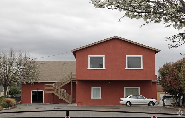
Property Detail
27911 E 12Th St
Oakland-Fremont-Berkeley, CA
LOT: 00001 BLK: 0025 AR: 0452 PAGE: 0080 ;LOT: 00033 BLK: AR: 0452 PAGE: 0080 ;LOT: 00034 BLK: AR: 0452 PAGE: 0080
452-0080-025-01
Alameda
Religious
California
B and X Area of moderate flood hazard, usually the area between the limits of the 100-year and 500-year floods.
1-6
2024
0.45 AC
2025
Hayward/Castro Valley
437900
East Bay/Oakland
6,788 SF
NEARBY LISTINGS FOR SALE OR LEASE
-
-
View all Hayward listings for sale on LoopNet.com
DEMOGRAPHICS near 27911 E 12Th St
1 mile
3 mile
5 mile
2025 Total Population
29,352
161,146
350,304
2030 Population
29,532
161,033
348,916
Pop Growth 2025-2030
+ 0.61%
(0.07%)
(0.40%)
Average Age
38
40
41
2025 Total Households
8,846
49,316
109,572
HH Growth 2025-2030
+ 0.68%
(0.13%)
(0.50%)
Median Household Inc
$104,274
$114,783
$117,406
Avg Household Size
3.20
3.10
3.10
2025 Avg HH Vehicles
2.00
2.00
2.00
Median Home Value
$730,699
$808,893
$889,946
Median Year Built
1976
1973
1973
Nearby Places
Map Layers
Map Styles
 Street
 Aerial
Transit
 Traffic
 Biking
Places
Listings with unknown addresses are not visible on the map
- Restaurants
- Banks
- Shops
- Fitness
- Groceries
PUBLIC TRANSPORTATION
COMMUTER RAIL
Drive
Walk
Distance
10 min
3.7 mi
Drive
Walk
Distance
10 min
3.7 mi
AIRPORT
Metro Oakland International
Drive
Walk
Distance
Metro Oakland International
21 min
13.5 mi
San Francisco International
Drive
Walk
Distance
San Francisco International
33 min
24.1 mi
Norman Y Mineta San Jose International
Drive
Walk
Distance
Norman Y Mineta San Jose International
35 min
26.3 mi
Freight Ports
Port of Oakland
Drive
Walk
Distance
Port of Oakland
25 min
18.0 mi
Nearby Properties
Address
Land Use
TOTAL SIZE
Lot Size
Zoning
Address
Land Use
TOTAL SIZE
Lot Size
Zoning
710,091 SF
50.34 AC
Address
Land Use
TOTAL SIZE
Lot Size
Zoning
240,556 SF
11.63 AC
Address
Land Use
TOTAL SIZE
Lot Size
Zoning
312,244 SF
31.84 AC
Address
Land Use
TOTAL SIZE
Lot Size
Zoning
52,720 SF
4.21 AC
Address
Land Use
TOTAL SIZE
Lot Size
Zoning
200,451 SF
11.22 AC
Address
Land Use
TOTAL SIZE
Lot Size
Zoning
236,976 SF
18.36 AC
Address
Land Use
TOTAL SIZE
Lot Size
Zoning
173,948 SF
6.10 AC
Address
Land Use
TOTAL SIZE
Lot Size
Zoning
333,302 SF
13.20 AC
Address
Land Use
TOTAL SIZE
Lot Size
Zoning
175,325 SF
2.91 AC
Address
Land Use
TOTAL SIZE
Lot Size
Zoning
470,929 SF
31.62 AC
Address
Land Use
TOTAL SIZE
Lot Size
Zoning
1.50 AC
Address
Land Use
TOTAL SIZE
Lot Size
Zoning
258,470 SF
11.64 AC
Address
Land Use
TOTAL SIZE
Lot Size
Zoning
58,991 SF
9.56 AC
Address
Land Use
TOTAL SIZE
Lot Size
Zoning
150,856 SF
5.99 AC
Address
Land Use
TOTAL SIZE
Lot Size
Zoning
187,926 SF
1.19 AC
Address
Land Use
TOTAL SIZE
Lot Size
Zoning
160,987 SF
7.20 AC
Address
Land Use
TOTAL SIZE
Lot Size
Zoning
89,145 SF
5.12 AC
Address
Land Use
TOTAL SIZE
Lot Size
Zoning
169,371 SF
4.63 AC
Address
Land Use
TOTAL SIZE
Lot Size
Zoning
146,599 SF
13.72 AC
Address
Land Use
TOTAL SIZE
Lot Size
Zoning
116,485 SF
1.81 AC
Address
Land Use
TOTAL SIZE
Lot Size
Zoning
137,889 SF
18.44 AC
Address
Land Use
TOTAL SIZE
Lot Size
Zoning
116,750 SF
4.72 AC
Address
Land Use
TOTAL SIZE
Lot Size
Zoning
154,113 SF
14.10 AC
Address
Land Use
TOTAL SIZE
Lot Size
Zoning
89,344 SF
4.36 AC
Address
Land Use
TOTAL SIZE
Lot Size
Zoning
214,200 SF
9.04 AC
Address
Land Use
TOTAL SIZE
Lot Size
Zoning
200,384 SF
10.26 AC
Address
Land Use
TOTAL SIZE
Lot Size
Zoning
266,149 SF
13.45 AC
I
Address
Land Use
TOTAL SIZE
Lot Size
Zoning
92,922 SF
5 AC
Address
Land Use
TOTAL SIZE
Lot Size
Zoning
100,128 SF
0.98 AC
Address
Land Use
TOTAL SIZE
Lot Size
Zoning
329,346 SF
29.36 AC
The World's #1 Commercial Real Estate Marketplace
Connect with us
© 2026 CoStar Group
The information above has been obtained from sources believed reliable. While we do not doubt its accuracy we have not verified it and make no guarantee, warranty or representation about it. It is your responsibility to independently confirm its accuracy and completeness. Any projections, opinions, assumptions, or estimates used are for example only and do not represent the current or future performance of the property. The value of this transaction to you depends on tax and other factors which should be evaluated by your tax, financial, and legal advisors. You and your advisors should conduct a careful, independent investigation of the property to determine to your satisfaction the suitability of the property for your needs.