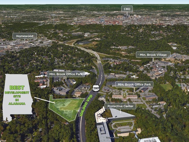
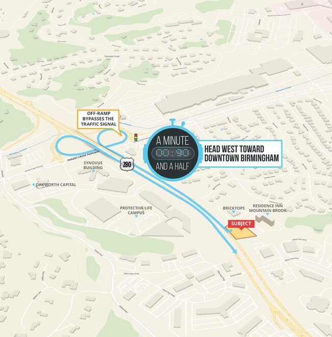
Property Record
2792 Highway 280 S, Mountain Brk, AL 35223

Current Lease Availabilities
NEARBY LISTINGS FOR SALE OR LEASE
Property Detail
2792 Highway 280 S
Birmingham-Hoover, AL
Mx 2800 Llc Sur No 2
28-00-08-3-006-016.003
LOT B MX 2800 SURVEY NO 2 PB 247 PG 85
Vacantlandnec
Jefferson
X
Alabama
01073C0557J
b
2023
1.10 AC
2024
Midtown
010703
Birmingham
DEMOGRAPHICS near 2792 Highway 280 S
1 Mile
3 Mile
5 Mile
2024 Total Population
7,945
75,666
173,609
2029 Population
7,807
74,174
171,454
Pop Growth 2024-2029
(1.74%)
(1.97%)
(1.24%)
Average Age
36
37
38
2024 Total Households
2,405
32,249
76,115
HH Growth 2024-2029
(2.99%)
(1.94%)
(1.16%)
Median Household Inc
$134,800
$75,895
$59,791
Avg Household Size
2.40
2.10
2.10
2024 Avg HH Vehicles
2.00
2.00
2.00
Median Home Value
$718,602
$492,239
$375,911
Median Year Built
1958
1969
1972
Nearby Places
Map Layers
Map Styles
 Street
 Aerial
- Restaurants
- Banks
- Shops
- Fitness
- Groceries
PUBLIC TRANSPORTATION
AIRPORT
Birmingham-Shuttlesworth International
DRIVE
WALK
Distance
Birmingham-Shuttlesworth International
16 min
9.2 mi
Freight Ports
Port of Mobile
DRIVE
WALK
Distance
Port of Mobile
278 min
253.7 mi
Nearby Properties
Address
Land Use
TOTAL SIZE
Lot Size
Zoning
Address
Land Use
TOTAL SIZE
Lot Size
Zoning
296,284 SF
12 AC
OI
Address
Land Use
TOTAL SIZE
Lot Size
Zoning
189,447 SF
3.67 AC
B4
Address
Land Use
TOTAL SIZE
Lot Size
Zoning
978,879 SF
43.50 AC
I3
Address
Land Use
TOTAL SIZE
Lot Size
Zoning
239,334 SF
4.42 AC
B6
Address
Land Use
TOTAL SIZE
Lot Size
Zoning
261,311 SF
20.85 AC
C1
Address
Land Use
TOTAL SIZE
Lot Size
Zoning
31,980 SF
99.92 AC
I3/P
Address
Land Use
TOTAL SIZE
Lot Size
Zoning
500,279 SF
52.57 AC
B2
Address
Land Use
TOTAL SIZE
Lot Size
Zoning
154,474 SF
12.50 AC
R-D
Address
Land Use
TOTAL SIZE
Lot Size
Zoning
46,161 SF
1.38 AC
M1-B
Address
Land Use
TOTAL SIZE
Lot Size
Zoning
95,993 SF
3.67 AC
M1
Address
Land Use
TOTAL SIZE
Lot Size
Zoning
229,669 SF
2.75 AC
B4
Address
Land Use
TOTAL SIZE
Lot Size
Zoning
200,927 SF
19 AC
PMUD
Address
Land Use
TOTAL SIZE
Lot Size
Zoning
81,807 SF
6.30 AC
C1
Address
Land Use
TOTAL SIZE
Lot Size
Zoning
109,411 SF
2.77 AC
B4
Address
Land Use
TOTAL SIZE
Lot Size
Zoning
1,666 SF
1.69 AC
M1
Address
Land Use
TOTAL SIZE
Lot Size
Zoning
51,699 SF
1.31 AC
PCD-
Address
Land Use
TOTAL SIZE
Lot Size
Zoning
32,948 SF
0.48 AC
B3
Address
Land Use
TOTAL SIZE
Lot Size
Zoning
30,453 SF
0.44 AC
B2
Address
Land Use
TOTAL SIZE
Lot Size
Zoning
329,064 SF
9 AC
I3
Address
Land Use
TOTAL SIZE
Lot Size
Zoning
156,986 SF
1.29 AC
M1
Address
Land Use
TOTAL SIZE
Lot Size
Zoning
62,543 SF
1.78 AC
R-D
Address
Land Use
TOTAL SIZE
Lot Size
Zoning
69,981 SF
4.90 AC
B2
Address
Land Use
TOTAL SIZE
Lot Size
Zoning
33,209 SF
3.11 AC
C4B
Address
Land Use
TOTAL SIZE
Lot Size
Zoning
361,937 SF
22 AC
R4
Address
Land Use
TOTAL SIZE
Lot Size
Zoning
282,421 SF
24.33 AC
R7
Address
Land Use
TOTAL SIZE
Lot Size
Zoning
331,413 SF
14.46 AC
R6
Address
Land Use
TOTAL SIZE
Lot Size
Zoning
65,685 SF
9.50 AC
B2
Address
Land Use
TOTAL SIZE
Lot Size
Zoning
62,516 SF
1.37 AC
I3
Address
Land Use
TOTAL SIZE
Lot Size
Zoning
52,922 SF
B3
Address
Land Use
TOTAL SIZE
Lot Size
Zoning
58,463 SF
11 AC
C1
The World's #1 Commercial Real Estate Marketplace
Connect with us
© 2026 CoStar Group
The information above has been obtained from sources believed reliable. While we do not doubt its accuracy we have not verified it and make no guarantee, warranty or representation about it. It is your responsibility to independently confirm its accuracy and completeness. Any projections, opinions, assumptions, or estimates used are for example only and do not represent the current or future performance of the property. The value of this transaction to you depends on tax and other factors which should be evaluated by your tax, financial, and legal advisors. You and your advisors should conduct a careful, independent investigation of the property to determine to your satisfaction the suitability of the property for your needs.