Property Record
27925 Golf Pointe Blvd, Farmington Hills, MI 48331


NEARBY LISTINGS FOR SALE OR LEASE
Property Detail
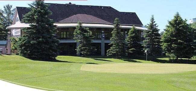
27925 Golf Pointe Blvd
23-07-400-025
T1N, R9E, SEC 7 PART OF SEC 7 BEG AT PT DIST N 00-00-25 W 107.00 FT & N 89-42-47 E 682.83 FT FROM S 1/4 COR, TH N 44-00-00 W
Restaurantbuilding
Oakland
AE
Michigan
26163C0035E
46.38 AC
2024
Farmington/Farm Hills
2024
Detroit
168700
Detroit-Warren-Dearborn, MI
5,048 SF
DEMOGRAPHICS near 27925 Golf Pointe Blvd
1 Mile
3 Mile
5 Mile
2024 Total Population
4,534
68,825
186,266
2029 Population
4,472
67,879
184,123
Pop Growth 2024-2029
(1.37%)
(1.37%)
(1.15%)
Average Age
47
43
43
2024 Total Households
1,908
29,250
78,717
HH Growth 2024-2029
(1.15%)
(1.28%)
(1.11%)
Median Household Inc
$118,640
$95,417
$96,687
Avg Household Size
2.30
2.30
2.30
2024 Avg HH Vehicles
2.00
2.00
2.00
Median Home Value
$366,440
$328,723
$327,052
Median Year Built
1989
1986
1983
Nearby Places
Map Layers
Map Styles
 Street
 Aerial
- Restaurants
- Banks
- Shops
- Fitness
- Groceries
PUBLIC TRANSPORTATION
AIRPORT
Detroit Metro Wayne County
DRIVE
WALK
Distance
Detroit Metro Wayne County
39 min
29.1 mi
Windsor International
DRIVE
WALK
Distance
Windsor International
60 min
35.4 mi
SALE & LEASE HISTORY
LISTING DATE
SALE/LEASE

Mar 12, 2025
For Sale
Aug 27, 2019
For Sale
Nearby Properties
Address
Land Use
TOTAL SIZE
Lot Size
Zoning
Address
Land Use
TOTAL SIZE
Lot Size
Zoning
162,600 SF
102.81 AC
RM-1
Address
Land Use
TOTAL SIZE
Lot Size
Zoning
1,393,561 SF
123.23 AC
AI
Address
Land Use
TOTAL SIZE
Lot Size
Zoning
486,998 SF
24.18 AC
R-C
Address
Land Use
TOTAL SIZE
Lot Size
Zoning
308,794 SF
76.30 AC
RI
Address
Land Use
TOTAL SIZE
Lot Size
Zoning
886 SF
26.58 AC
GATEWY
Address
Land Use
TOTAL SIZE
Lot Size
Zoning
24.08 AC
BV
Address
Land Use
TOTAL SIZE
Lot Size
Zoning
507,334 SF
49.09 AC
II
Address
Land Use
TOTAL SIZE
Lot Size
Zoning
9.72 AC
OS-1
Address
Land Use
TOTAL SIZE
Lot Size
Zoning
1,792 SF
59.30 AC
OST
Address
Land Use
TOTAL SIZE
Lot Size
Zoning
Address
Land Use
TOTAL SIZE
Lot Size
Zoning
321,204 SF
26.06 AC
BI
Address
Land Use
TOTAL SIZE
Lot Size
Zoning
17,277 SF
17.73 AC
R-A
Address
Land Use
TOTAL SIZE
Lot Size
Zoning
14,463 SF
26.97 AC
TC-1
Address
Land Use
TOTAL SIZE
Lot Size
Zoning
325,281 SF
36.25 AC
AI
Address
Land Use
TOTAL SIZE
Lot Size
Zoning
346,647 SF
21.12 AC
AI
Address
Land Use
TOTAL SIZE
Lot Size
Zoning
327,206 SF
29.93 AC
AI
Address
Land Use
TOTAL SIZE
Lot Size
Zoning
274,645 SF
39.27 AC
AI
Address
Land Use
TOTAL SIZE
Lot Size
Zoning
Address
Land Use
TOTAL SIZE
Lot Size
Zoning
433,306 SF
39.80 AC
II
Address
Land Use
TOTAL SIZE
Lot Size
Zoning
312,634 SF
20.19 AC
AI
Address
Land Use
TOTAL SIZE
Lot Size
Zoning
269,975 SF
23.88 AC
AI
Address
Land Use
TOTAL SIZE
Lot Size
Zoning
63,152 SF
14 AC
R-C
Address
Land Use
TOTAL SIZE
Lot Size
Zoning
103,882 SF
34.97 AC
TC
Address
Land Use
TOTAL SIZE
Lot Size
Zoning
287,023 SF
22.20 AC
Address
Land Use
TOTAL SIZE
Lot Size
Zoning
278,387 SF
22.51 AC
II
Address
Land Use
TOTAL SIZE
Lot Size
Zoning
226,834 SF
21.59 AC
AI
Address
Land Use
TOTAL SIZE
Lot Size
Zoning
249,084 SF
19.65 AC
AI
Address
Land Use
TOTAL SIZE
Lot Size
Zoning
226,753 SF
27.92 AC
AI
Address
Land Use
TOTAL SIZE
Lot Size
Zoning
19.26 AC
R-A
Address
Land Use
TOTAL SIZE
Lot Size
Zoning
222,440 SF
11.57 AC
BI
The World's #1 Commercial Real Estate Marketplace
Connect with us
© 2025 CoStar Group
The information above has been obtained from sources believed reliable. While we do not doubt its accuracy we have not verified it and make no guarantee, warranty or representation about it. It is your responsibility to independently confirm its accuracy and completeness. Any projections, opinions, assumptions, or estimates used are for example only and do not represent the current or future performance of the property. The value of this transaction to you depends on tax and other factors which should be evaluated by your tax, financial, and legal advisors. You and your advisors should conduct a careful, independent investigation of the property to determine to your satisfaction the suitability of the property for your needs.