Property Record
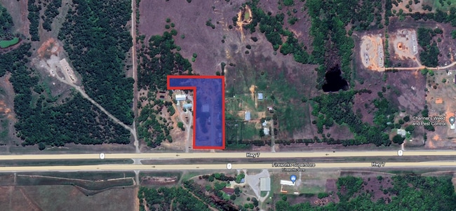
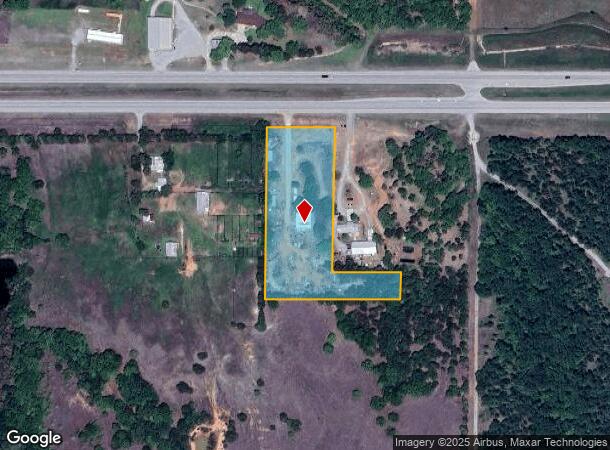
279389 W Highway 7, Marlow, OK 73055
This Property Is For Sale
NEARBY LISTINGS FOR SALE OR LEASE
Property Detail
279389 W Highway 7
Duncan, OK
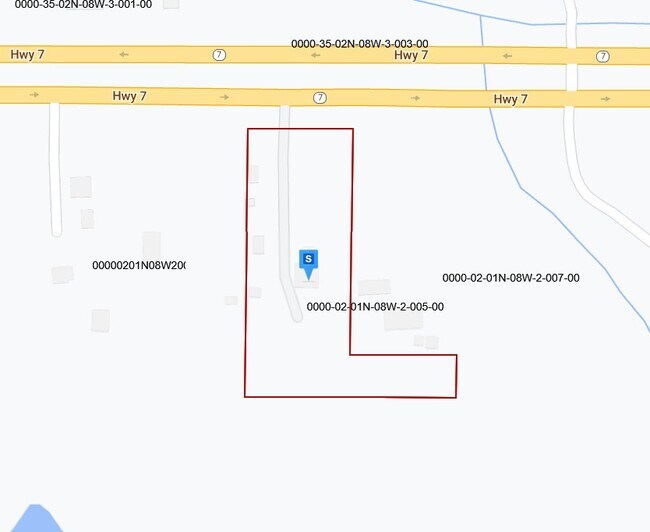
T1n-R8w
0000-02-01N-08W-2-008-00
02-1N-8W 3.10 AC BEG NW/C E1/2 LT 3 (NENW) S615 E440 N95 W220 N528 W220 TO BEG
Commercialnec
Stephens
X
Oklahoma
40051C0600E
3
2024
3.10 AC
2025
Oklahoma West Area
000901
Other Market Areas
DEMOGRAPHICS near 279389 W Highway 7
1 Mile
3 Mile
5 Mile
2024 Total Population
13
1,167
9,055
2029 Population
14
1,180
9,333
Pop Growth 2024-2029
+ 7.69%
+ 1.11%
+ 3.07%
Average Age
40
43
44
2024 Total Households
5
448
3,714
HH Growth 2024-2029
0.00%
+ 0.67%
+ 2.88%
Median Household Inc
$74,999
$68,977
$62,164
Avg Household Size
2.40
2.60
2.40
2024 Avg HH Vehicles
3.00
2.00
2.00
Median Home Value
$174,999
$203,846
$177,283
Median Year Built
1989
1983
1980
Nearby Places
- Restaurants
- Banks
- Shops
- Fitness
- Groceries
PUBLIC TRANSPORTATION
AIRPORT
Lawton-Fort Sill Regional
DRIVE
WALK
Distance
Lawton-Fort Sill Regional
36 min
25.8 mi
Nearby Properties
Address
Land Use
TOTAL SIZE
Lot Size
Zoning
Address
Land Use
TOTAL SIZE
Lot Size
Zoning
154 SF
14 AC
Address
Land Use
TOTAL SIZE
Lot Size
Zoning
5,037 SF
13.41 AC
Address
Land Use
TOTAL SIZE
Lot Size
Zoning
2,989 SF
13.49 AC
C2
Address
Land Use
TOTAL SIZE
Lot Size
Zoning
160 SF
6.70 AC
C2
Address
Land Use
TOTAL SIZE
Lot Size
Zoning
532 SF
40.47 AC
C1
Address
Land Use
TOTAL SIZE
Lot Size
Zoning
6,250 SF
5 AC
C1
Address
Land Use
TOTAL SIZE
Lot Size
Zoning
10,500 SF
1.91 AC
C2
Address
Land Use
TOTAL SIZE
Lot Size
Zoning
11,768 SF
1.38 AC
C2
Address
Land Use
TOTAL SIZE
Lot Size
Zoning
3,708 SF
3.79 AC
R1
Address
Land Use
TOTAL SIZE
Lot Size
Zoning
3,845 SF
2.37 AC
Address
Land Use
TOTAL SIZE
Lot Size
Zoning
30,000 SF
4.88 AC
C2
Address
Land Use
TOTAL SIZE
Lot Size
Zoning
3,985 SF
5 AC
C1
Address
Land Use
TOTAL SIZE
Lot Size
Zoning
1,800 SF
14.65 AC
C2
Address
Land Use
TOTAL SIZE
Lot Size
Zoning
3,600 SF
45.04 AC
Address
Land Use
TOTAL SIZE
Lot Size
Zoning
2,400 SF
80 AC
Address
Land Use
TOTAL SIZE
Lot Size
Zoning
3,200 SF
3.28 AC
C2
Address
Land Use
TOTAL SIZE
Lot Size
Zoning
1,960 SF
2.21 AC
R1
Address
Land Use
TOTAL SIZE
Lot Size
Zoning
10,685 SF
2.63 AC
C2
Address
Land Use
TOTAL SIZE
Lot Size
Zoning
6,868 SF
4.14 AC
C1
Address
Land Use
TOTAL SIZE
Lot Size
Zoning
14,640 SF
5 AC
Address
Land Use
TOTAL SIZE
Lot Size
Zoning
408 SF
12.39 AC
R1
Address
Land Use
TOTAL SIZE
Lot Size
Zoning
3,961 SF
2.50 AC
R1
Address
Land Use
TOTAL SIZE
Lot Size
Zoning
5,000 SF
4.28 AC
R1
Address
Land Use
TOTAL SIZE
Lot Size
Zoning
160 SF
5.73 AC
Address
Land Use
TOTAL SIZE
Lot Size
Zoning
2,500 SF
1.15 AC
C1
Address
Land Use
TOTAL SIZE
Lot Size
Zoning
2,196 SF
1.99 AC
C2
Address
Land Use
TOTAL SIZE
Lot Size
Zoning
7,800 SF
4 AC
C2
Address
Land Use
TOTAL SIZE
Lot Size
Zoning
2,052 SF
1.29 AC
R1
Address
Land Use
TOTAL SIZE
Lot Size
Zoning
4,654 SF
22.11 AC
C2
Address
Land Use
TOTAL SIZE
Lot Size
Zoning
1,984 SF
4.19 AC
R1
The World's #1 Commercial Real Estate Marketplace
Connect with us
© 2025 CoStar Group
The information above has been obtained from sources believed reliable. While we do not doubt its accuracy we have not verified it and make no guarantee, warranty or representation about it. It is your responsibility to independently confirm its accuracy and completeness. Any projections, opinions, assumptions, or estimates used are for example only and do not represent the current or future performance of the property. The value of this transaction to you depends on tax and other factors which should be evaluated by your tax, financial, and legal advisors. You and your advisors should conduct a careful, independent investigation of the property to determine to your satisfaction the suitability of the property for your needs.