Property Record
2795 Bonds Lake Rd Nw, Conyers, GA 30012
NEARBY LISTINGS FOR SALE OR LEASE
-
-
View all Conyers listings for sale on LoopNet.com
Property Detail
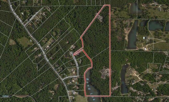
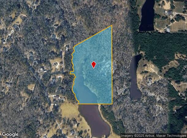
2795 Bonds Lake Rd Nw
Atlanta-Sandy Springs-Roswell, GA
Rural
037-0-01-033F
BONDS LAKE RD
Privatepreserveopenspacevacantlandforestlandconservation
Rockdale
AE
Georgia
13247C0082D
260
2024
24.94 AC
2024
I-20 East/Conyers
060101
Atlanta
DEMOGRAPHICS near 2795 Bonds Lake Rd Nw
1 Mile
3 Mile
5 Mile
2024 Total Population
1,994
21,547
76,826
2029 Population
2,068
22,154
78,816
Pop Growth 2024-2029
+ 3.71%
+ 2.82%
+ 2.59%
Average Age
35
37
38
2024 Total Households
582
7,218
27,117
HH Growth 2024-2029
+ 3.78%
+ 2.88%
+ 2.43%
Median Household Inc
$65,823
$63,416
$63,312
Avg Household Size
3.20
2.90
2.70
2024 Avg HH Vehicles
2.00
2.00
2.00
Median Home Value
$93,192
$185,514
$215,595
Median Year Built
1980
1986
1992
Nearby Places
Map Layers
Map Styles
 Street
 Aerial
- Restaurants
- Banks
- Shops
- Fitness
- Groceries
PUBLIC TRANSPORTATION
AIRPORT
Hartsfield - Jackson Atlanta International
DRIVE
WALK
Distance
Hartsfield - Jackson Atlanta International
43 min
29.7 mi
Freight Ports
Georgia Ports - Savannah
DRIVE
WALK
Distance
Georgia Ports - Savannah
286 min
244.7 mi
Nearby Properties
Address
Land Use
TOTAL SIZE
Lot Size
Zoning
Address
Land Use
TOTAL SIZE
Lot Size
Zoning
290,616 SF
23.84 AC
M-1
Address
Land Use
TOTAL SIZE
Lot Size
Zoning
28,024 SF
11.24 AC
R1
Address
Land Use
TOTAL SIZE
Lot Size
Zoning
3,888 SF
21.05 AC
RM/C
Address
Land Use
TOTAL SIZE
Lot Size
Zoning
196,560 SF
12.06 AC
MI
Address
Land Use
TOTAL SIZE
Lot Size
Zoning
14,575 SF
14.55 AC
OI
Address
Land Use
TOTAL SIZE
Lot Size
Zoning
1,968 SF
26.91 AC
M2
Address
Land Use
TOTAL SIZE
Lot Size
Zoning
713,040 SF
67.04 AC
M1
Address
Land Use
TOTAL SIZE
Lot Size
Zoning
65,460 SF
32.41 AC
M1
Address
Land Use
TOTAL SIZE
Lot Size
Zoning
100,400 SF
19.73 AC
MI
Address
Land Use
TOTAL SIZE
Lot Size
Zoning
29.96 AC
R1
Address
Land Use
TOTAL SIZE
Lot Size
Zoning
20,942 SF
22.78 AC
BG
Address
Land Use
TOTAL SIZE
Lot Size
Zoning
16,100 SF
5.10 AC
BG
Address
Land Use
TOTAL SIZE
Lot Size
Zoning
31,000 SF
2.07 AC
M
Address
Land Use
TOTAL SIZE
Lot Size
Zoning
5,038 SF
21.41 AC
M2
Address
Land Use
TOTAL SIZE
Lot Size
Zoning
69,088 SF
9.37 AC
BG
Address
Land Use
TOTAL SIZE
Lot Size
Zoning
30,000 SF
5.49 AC
R1
Address
Land Use
TOTAL SIZE
Lot Size
Zoning
476,695 SF
21.50 AC
M1
Address
Land Use
TOTAL SIZE
Lot Size
Zoning
3,050 SF
2.12 AC
M1/C
Address
Land Use
TOTAL SIZE
Lot Size
Zoning
7,980 SF
1.20 AC
BN
Address
Land Use
TOTAL SIZE
Lot Size
Zoning
46,452 SF
20 AC
AR
Address
Land Use
TOTAL SIZE
Lot Size
Zoning
3,057 SF
27.27 AC
RM
Address
Land Use
TOTAL SIZE
Lot Size
Zoning
14,030 SF
6.70 AC
M1
Address
Land Use
TOTAL SIZE
Lot Size
Zoning
25,303 SF
7.67 AC
M1
Address
Land Use
TOTAL SIZE
Lot Size
Zoning
47,674 SF
6.22 AC
M1
Address
Land Use
TOTAL SIZE
Lot Size
Zoning
14,280 SF
3.89 AC
BN
Address
Land Use
TOTAL SIZE
Lot Size
Zoning
12,170 SF
22.83 AC
BG/OI
Address
Land Use
TOTAL SIZE
Lot Size
Zoning
8,986 SF
25.72 AC
RS10/CU
Address
Land Use
TOTAL SIZE
Lot Size
Zoning
9,869 SF
3.20 AC
C1/C
Address
Land Use
TOTAL SIZE
Lot Size
Zoning
9,170 SF
2.51 AC
M1
Address
Land Use
TOTAL SIZE
Lot Size
Zoning
11,850 SF
5 AC
MI
The World's #1 Commercial Real Estate Marketplace
Connect with us
© 2025 CoStar Group
The information above has been obtained from sources believed reliable. While we do not doubt its accuracy we have not verified it and make no guarantee, warranty or representation about it. It is your responsibility to independently confirm its accuracy and completeness. Any projections, opinions, assumptions, or estimates used are for example only and do not represent the current or future performance of the property. The value of this transaction to you depends on tax and other factors which should be evaluated by your tax, financial, and legal advisors. You and your advisors should conduct a careful, independent investigation of the property to determine to your satisfaction the suitability of the property for your needs.