Property Record
27984 State Highway 189 Rd, Lake Arrowhead, CA 92352

NEARBY LISTINGS FOR SALE OR LEASE
-
-
View all Lake Arrowhead listings for sale on LoopNet.com
Property Detail
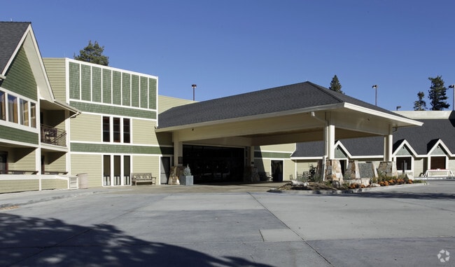
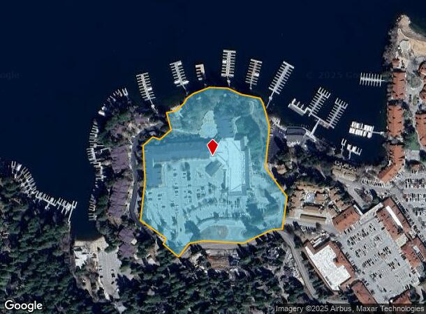
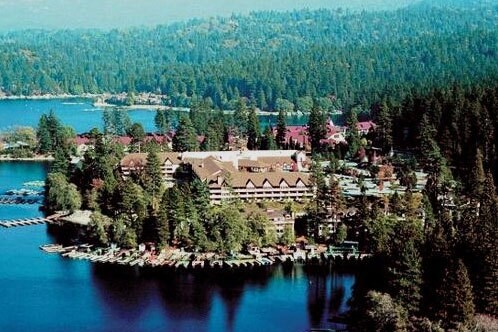
27984 State Highway 189 Rd
Riverside-San Bernardino-Ontario, CA
Tract 10908
0335-101-53
TRACT 10908 LOT 3 EX BEG AT MOST NLY COR COMMON TO LOTS 2 AND 3 TRACT 10908 TH S 13 DEG 14 MIN 26 SECONDS W 127.75 FT ALG WLY LI SD LOT 3 TO AN ANGLE PT THEREIN AND POINT A TH LEAVING WLY LI SD LOT 3 N 49 DEG 54 MIN 53 SECONDS E 65 FT TH N
Hotel
San Bernardino
A
California
06071C7240H
2,3
2024
8.77 AC
2025
San Bernardino Surrounding
010906
Inland Empire (California)
160,928 SF
DEMOGRAPHICS near 27984 State Highway 189 Rd
1 Mile
3 Mile
5 Mile
2024 Total Population
1,663
10,399
15,655
2029 Population
1,665
10,304
15,335
Pop Growth 2024-2029
+ 0.12%
(0.91%)
(2.04%)
Average Age
46
45
44
2024 Total Households
709
4,259
6,423
HH Growth 2024-2029
0.00%
(0.94%)
(2.09%)
Median Household Inc
$86,325
$93,157
$88,433
Avg Household Size
2.20
2.40
2.40
2024 Avg HH Vehicles
2.00
2.00
2.00
Median Home Value
$647,418
$626,090
$500,231
Median Year Built
1973
1975
1973
Nearby Places
Map Layers
Map Styles
 Street
 Aerial
- Restaurants
- Banks
- Shops
- Fitness
- Groceries
PUBLIC TRANSPORTATION
AIRPORT
Ontario International
DRIVE
WALK
Distance
Ontario International
61 min
42.2 mi
Freight Ports
Port of Long Beach
DRIVE
WALK
Distance
Port of Long Beach
118 min
90.2 mi
Nearby Properties
Address
Land Use
TOTAL SIZE
Lot Size
Zoning
Address
Land Use
TOTAL SIZE
Lot Size
Zoning
185,773 SF
15.42 AC
LACG
Address
Land Use
TOTAL SIZE
Lot Size
Zoning
79,205 SF
17.72 AC
Address
Land Use
TOTAL SIZE
Lot Size
Zoning
78,044 SF
3.18 AC
LACS
Address
Land Use
TOTAL SIZE
Lot Size
Zoning
32,675 SF
91.96 AC
LARC
Address
Land Use
TOTAL SIZE
Lot Size
Zoning
34,726 SF
1.02 AC
LACG
Address
Land Use
TOTAL SIZE
Lot Size
Zoning
13,816 SF
28.10 AC
Address
Land Use
TOTAL SIZE
Lot Size
Zoning
32,648 SF
1.44 AC
LACGSCP
Address
Land Use
TOTAL SIZE
Lot Size
Zoning
Address
Land Use
TOTAL SIZE
Lot Size
Zoning
172.99 AC
Address
Land Use
TOTAL SIZE
Lot Size
Zoning
24,570 SF
2.24 AC
LACG
Address
Land Use
TOTAL SIZE
Lot Size
Zoning
11,772 SF
0.22 AC
LACG
Address
Land Use
TOTAL SIZE
Lot Size
Zoning
Address
Land Use
TOTAL SIZE
Lot Size
Zoning
143.31 AC
Address
Land Use
TOTAL SIZE
Lot Size
Zoning
22,887 SF
19.30 AC
LARS14M
Address
Land Use
TOTAL SIZE
Lot Size
Zoning
56.70 AC
LARS14M
Address
Land Use
TOTAL SIZE
Lot Size
Zoning
22,542 SF
7.03 AC
LARS14M
Address
Land Use
TOTAL SIZE
Lot Size
Zoning
20,868 SF
68.79 AC
LASDRES
Address
Land Use
TOTAL SIZE
Lot Size
Zoning
25,759 SF
0.98 AC
LACGSCP
Address
Land Use
TOTAL SIZE
Lot Size
Zoning
3,570 SF
0.86 AC
LACS
Address
Land Use
TOTAL SIZE
Lot Size
Zoning
31,164 SF
0.82 AC
LACGSCP
Address
Land Use
TOTAL SIZE
Lot Size
Zoning
15,462 SF
0.52 AC
LACGSCP
Address
Land Use
TOTAL SIZE
Lot Size
Zoning
Address
Land Use
TOTAL SIZE
Lot Size
Zoning
20,228 SF
2.55 AC
LARS14M
Address
Land Use
TOTAL SIZE
Lot Size
Zoning
61,908 SF
0.19 AC
LACG
Address
Land Use
TOTAL SIZE
Lot Size
Zoning
2,650 SF
1.33 AC
LACG
Address
Land Use
TOTAL SIZE
Lot Size
Zoning
3.45 AC
LACGSCP
Address
Land Use
TOTAL SIZE
Lot Size
Zoning
105,000 SF
39.29 AC
LASDRES
Address
Land Use
TOTAL SIZE
Lot Size
Zoning
2,784 SF
0.70 AC
LACN
Address
Land Use
TOTAL SIZE
Lot Size
Zoning
8,501 SF
2.09 AC
LARM
The World's #1 Commercial Real Estate Marketplace
Connect with us
© 2026 CoStar Group
The information above has been obtained from sources believed reliable. While we do not doubt its accuracy we have not verified it and make no guarantee, warranty or representation about it. It is your responsibility to independently confirm its accuracy and completeness. Any projections, opinions, assumptions, or estimates used are for example only and do not represent the current or future performance of the property. The value of this transaction to you depends on tax and other factors which should be evaluated by your tax, financial, and legal advisors. You and your advisors should conduct a careful, independent investigation of the property to determine to your satisfaction the suitability of the property for your needs.