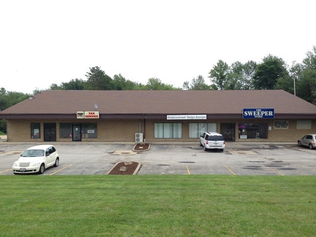
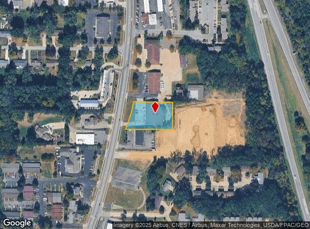
Property Record
2799 Cleveland Rd, Wooster, OH 44691
NEARBY LISTINGS FOR SALE OR LEASE
Property Detail
2799 Cleveland Rd
67-01046-000
13-16-27 MPT SW .907A MP 165 CD 2045
Stripcommercialcenter
Wayne
X
Ohio
39169C0208E
0.91 AC
2024
Ohio North Area
2024
Other Market Areas
000300
Wooster, OH
11,456 SF
DEMOGRAPHICS near 2799 Cleveland Rd
1 Mile
3 Mile
5 Mile
2024 Total Population
6,720
30,434
39,992
2029 Population
6,789
30,737
40,296
Pop Growth 2024-2029
+ 1.03%
+ 1.00%
+ 0.76%
Average Age
44
42
41
2024 Total Households
2,941
12,549
16,127
HH Growth 2024-2029
+ 0.85%
+ 0.89%
+ 0.68%
Median Household Inc
$65,176
$55,457
$56,712
Avg Household Size
2.10
2.20
2.20
2024 Avg HH Vehicles
2.00
2.00
2.00
Median Home Value
$188,267
$176,066
$182,595
Median Year Built
1979
1976
1975
Nearby Places
Map Layers
Map Styles
 Street
 Aerial
- Restaurants
- Banks
- Shops
- Fitness
- Groceries
PUBLIC TRANSPORTATION
AIRPORT
Akron-Canton Regional
DRIVE
WALK
Distance
Akron-Canton Regional
55 min
44.5 mi
SALE & LEASE HISTORY
LISTING DATE
SALE/LEASE

Sep 25, 2016
For Lease
Nov 02, 2017
For Sale
Mar 24, 2021
For Lease
Jul 19, 2017
For Lease
Jul 10, 2019
For Sale
Dec 06, 2018
For Sale
Dec 06, 2018
For Lease
Aug 18, 2017
For Lease
Nearby Properties
Address
Land Use
TOTAL SIZE
Lot Size
Zoning
Address
Land Use
TOTAL SIZE
Lot Size
Zoning
537,309 SF
43.72 AC
CF
Address
Land Use
TOTAL SIZE
Lot Size
Zoning
70,726 SF
9 AC
CF
Address
Land Use
TOTAL SIZE
Lot Size
Zoning
152,523 SF
74.14 AC
CF
Address
Land Use
TOTAL SIZE
Lot Size
Zoning
81,133 SF
41.43 AC
CF
Address
Land Use
TOTAL SIZE
Lot Size
Zoning
608,111 SF
44 AC
Address
Land Use
TOTAL SIZE
Lot Size
Zoning
59.44 AC
Address
Land Use
TOTAL SIZE
Lot Size
Zoning
51.79 AC
M2
Address
Land Use
TOTAL SIZE
Lot Size
Zoning
227,500 SF
58.38 AC
Address
Land Use
TOTAL SIZE
Lot Size
Zoning
198,900 SF
17.94 AC
Address
Land Use
TOTAL SIZE
Lot Size
Zoning
48,096 SF
1.67 AC
C4
Address
Land Use
TOTAL SIZE
Lot Size
Zoning
109.56 AC
M2
Address
Land Use
TOTAL SIZE
Lot Size
Zoning
46,230 SF
38.46 AC
Address
Land Use
TOTAL SIZE
Lot Size
Zoning
50,110 SF
19.26 AC
CF
Address
Land Use
TOTAL SIZE
Lot Size
Zoning
160,158 SF
14.21 AC
Address
Land Use
TOTAL SIZE
Lot Size
Zoning
62,910 SF
11.24 AC
C5
Address
Land Use
TOTAL SIZE
Lot Size
Zoning
47,160 SF
3.22 AC
C4
Address
Land Use
TOTAL SIZE
Lot Size
Zoning
125,350 SF
17.20 AC
C5
Address
Land Use
TOTAL SIZE
Lot Size
Zoning
98,810 SF
12.42 AC
CF
Address
Land Use
TOTAL SIZE
Lot Size
Zoning
4,486 SF
5.57 AC
CF
Address
Land Use
TOTAL SIZE
Lot Size
Zoning
2,536 SF
16.79 AC
R4
Address
Land Use
TOTAL SIZE
Lot Size
Zoning
85,910 SF
4.33 AC
Address
Land Use
TOTAL SIZE
Lot Size
Zoning
105,000 SF
25.29 AC
M2
Address
Land Use
TOTAL SIZE
Lot Size
Zoning
62,976 SF
10.46 AC
CF
Address
Land Use
TOTAL SIZE
Lot Size
Zoning
302,400 SF
24.51 AC
M2
Address
Land Use
TOTAL SIZE
Lot Size
Zoning
71,631 SF
17.88 AC
M1
Address
Land Use
TOTAL SIZE
Lot Size
Zoning
58,600 SF
6.30 AC
CF
Address
Land Use
TOTAL SIZE
Lot Size
Zoning
81,724 SF
19.59 AC
CF
Address
Land Use
TOTAL SIZE
Lot Size
Zoning
10.68 AC
M3
Address
Land Use
TOTAL SIZE
Lot Size
Zoning
71,511 SF
9.53 AC
CF
Address
Land Use
TOTAL SIZE
Lot Size
Zoning
21,026 SF
11.77 AC
The World's #1 Commercial Real Estate Marketplace
Connect with us
© 2025 CoStar Group
The information above has been obtained from sources believed reliable. While we do not doubt its accuracy we have not verified it and make no guarantee, warranty or representation about it. It is your responsibility to independently confirm its accuracy and completeness. Any projections, opinions, assumptions, or estimates used are for example only and do not represent the current or future performance of the property. The value of this transaction to you depends on tax and other factors which should be evaluated by your tax, financial, and legal advisors. You and your advisors should conduct a careful, independent investigation of the property to determine to your satisfaction the suitability of the property for your needs.