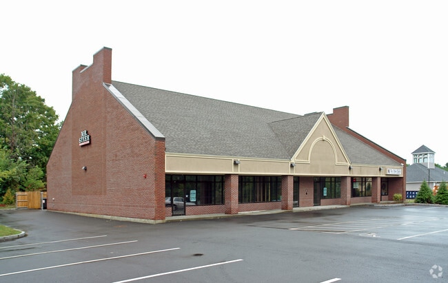
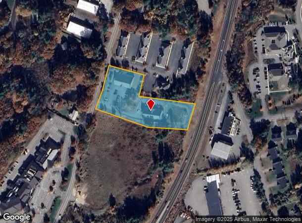
Property Record
27A Buttrick Rd, Londonderry, NH 03053
NEARBY LISTINGS FOR SALE OR LEASE
Property Detail
27A Buttrick Rd
Boston-Cambridge-Newton, MA-NH
Buttrick Vil
LOND-000006-000000-000030
Rockingham
Commercialnec
New Hampshire
X
30-0
33015C0526E
1.24 AC
2024
Rockingham
2024
Boston
003701
DEMOGRAPHICS near 27A Buttrick Rd
1 Mile
3 Mile
5 Mile
2024 Total Population
3,484
27,780
64,366
2029 Population
3,604
28,814
66,629
Pop Growth 2024-2029
+ 3.44%
+ 3.72%
+ 3.52%
Average Age
44
41
41
2024 Total Households
1,435
10,475
24,336
HH Growth 2024-2029
+ 3.28%
+ 3.66%
+ 3.44%
Median Household Inc
$101,755
$109,614
$111,045
Avg Household Size
2.40
2.60
2.60
2024 Avg HH Vehicles
2.00
2.00
2.00
Median Home Value
$392,856
$384,009
$401,296
Median Year Built
1984
1981
1982
Nearby Places
Map Layers
Map Styles
 Street
 Aerial
- Restaurants
- Banks
- Shops
- Fitness
- Groceries
PUBLIC TRANSPORTATION
AIRPORT
Manchester Boston Regional
DRIVE
WALK
Distance
Manchester Boston Regional
23 min
9.6 mi
Freight Ports
Port of Boston
DRIVE
WALK
Distance
Port of Boston
69 min
46.4 mi
Nearby Properties
Address
Land Use
TOTAL SIZE
Lot Size
Zoning
Address
Land Use
TOTAL SIZE
Lot Size
Zoning
15.44 AC
AR-I
Address
Land Use
TOTAL SIZE
Lot Size
Zoning
214,583 SF
110.37 AC
AR-I
Address
Land Use
TOTAL SIZE
Lot Size
Zoning
186,072 SF
18.64 AC
C-I
Address
Land Use
TOTAL SIZE
Lot Size
Zoning
146,407 SF
15.39 AC
OMB
Address
Land Use
TOTAL SIZE
Lot Size
Zoning
133,188 SF
1.53 AC
AR-I
Address
Land Use
TOTAL SIZE
Lot Size
Zoning
12.73 AC
C-I
Address
Land Use
TOTAL SIZE
Lot Size
Zoning
30.26 AC
C-I
Address
Land Use
TOTAL SIZE
Lot Size
Zoning
31.14 AC
AR-I
Address
Land Use
TOTAL SIZE
Lot Size
Zoning
195,610 SF
20.49 AC
C-I
Address
Land Use
TOTAL SIZE
Lot Size
Zoning
22.09 AC
AR-I
Address
Land Use
TOTAL SIZE
Lot Size
Zoning
90,406 SF
24.78 AC
AR-I
Address
Land Use
TOTAL SIZE
Lot Size
Zoning
108,248 SF
5.92 AC
OMB
Address
Land Use
TOTAL SIZE
Lot Size
Zoning
80,710 SF
20 AC
AR-I
Address
Land Use
TOTAL SIZE
Lot Size
Zoning
41,989 SF
C-III
Address
Land Use
TOTAL SIZE
Lot Size
Zoning
42,956 SF
2.31 AC
Address
Land Use
TOTAL SIZE
Lot Size
Zoning
60,572 SF
5.65 AC
C-I
Address
Land Use
TOTAL SIZE
Lot Size
Zoning
11.28 AC
C-I
Address
Land Use
TOTAL SIZE
Lot Size
Zoning
16.50 AC
C-II
Address
Land Use
TOTAL SIZE
Lot Size
Zoning
34,442 SF
99.29 AC
AR-I
Address
Land Use
TOTAL SIZE
Lot Size
Zoning
59,544 SF
20.23 AC
C-II
Address
Land Use
TOTAL SIZE
Lot Size
Zoning
32.45 AC
C-II
Address
Land Use
TOTAL SIZE
Lot Size
Zoning
2.21 AC
GC
Address
Land Use
TOTAL SIZE
Lot Size
Zoning
15,000 SF
C-III
Address
Land Use
TOTAL SIZE
Lot Size
Zoning
3,720 SF
14.65 AC
C-I
Address
Land Use
TOTAL SIZE
Lot Size
Zoning
145 AC
IND1
Address
Land Use
TOTAL SIZE
Lot Size
Zoning
45,330 SF
1 AC
R3
Address
Land Use
TOTAL SIZE
Lot Size
Zoning
37,931 SF
1.31 AC
CBD
Address
Land Use
TOTAL SIZE
Lot Size
Zoning
9.67 AC
C-I
Address
Land Use
TOTAL SIZE
Lot Size
Zoning
44,280 SF
1 AC
R3
Address
Land Use
TOTAL SIZE
Lot Size
Zoning
25,083 SF
1.42 AC
C-III
The World's #1 Commercial Real Estate Marketplace
Connect with us
© 2025 CoStar Group
The information above has been obtained from sources believed reliable. While we do not doubt its accuracy we have not verified it and make no guarantee, warranty or representation about it. It is your responsibility to independently confirm its accuracy and completeness. Any projections, opinions, assumptions, or estimates used are for example only and do not represent the current or future performance of the property. The value of this transaction to you depends on tax and other factors which should be evaluated by your tax, financial, and legal advisors. You and your advisors should conduct a careful, independent investigation of the property to determine to your satisfaction the suitability of the property for your needs.