Property Record
28 Airway Dr, Lagrangeville, NY 12540
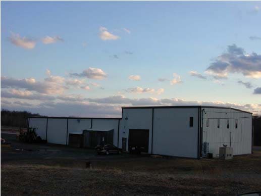

This Property Is For Sale
NEARBY LISTINGS FOR SALE OR LEASE
-
-
View all Lagrangeville listings for sale on LoopNet.com
Property Detail
28 Airway Dr
135400-6662-00-337269-0003
T-HANGAR 4-G
Transportationcommunicationsgeneral
Dutchess
X
New York
36027C0403E
337
2025
Fishkill
2024
Westchester/So Connecticut
180001
Dutchess County-Putnam County, NY
1,076 SF
DEMOGRAPHICS near 28 Airway Dr
1 Mile
3 Mile
5 Mile
2024 Total Population
985
4,387
14,652
2029 Population
998
4,416
14,712
Pop Growth 2024-2029
+ 1.32%
+ 0.66%
+ 0.41%
Average Age
45
44
43
2024 Total Households
340
1,536
5,327
HH Growth 2024-2029
+ 1.47%
+ 0.78%
+ 0.45%
Median Household Inc
$90,159
$95,579
$102,194
Avg Household Size
2.70
2.70
2.70
2024 Avg HH Vehicles
2.00
2.00
2.00
Median Home Value
$458,235
$449,226
$425,018
Median Year Built
1980
1978
1974
Nearby Places
- Restaurants
- Banks
- Shops
- Fitness
- Groceries
PUBLIC TRANSPORTATION
AIRPORT
New York Stewart International
DRIVE
WALK
Distance
New York Stewart International
55 min
35.1 mi
Freight Ports
Port of New Haven
DRIVE
WALK
Distance
Port of New Haven
110 min
75.2 mi
Nearby Properties
Address
Land Use
TOTAL SIZE
Lot Size
Zoning
Address
Land Use
TOTAL SIZE
Lot Size
Zoning
697.10 AC
C
Address
Land Use
TOTAL SIZE
Lot Size
Zoning
42,493 SF
76 AC
RA3
Address
Land Use
TOTAL SIZE
Lot Size
Zoning
41 SF
66.40 AC
RR10
Address
Land Use
TOTAL SIZE
Lot Size
Zoning
23,053 SF
165.05 AC
RA3
Address
Land Use
TOTAL SIZE
Lot Size
Zoning
162.70 AC
RD10
Address
Land Use
TOTAL SIZE
Lot Size
Zoning
3,842 SF
167.90 AC
RR10
Address
Land Use
TOTAL SIZE
Lot Size
Zoning
21,925 SF
4.20 AC
GB
Address
Land Use
TOTAL SIZE
Lot Size
Zoning
6,059 SF
15.09 AC
RL5
Address
Land Use
TOTAL SIZE
Lot Size
Zoning
7,844 SF
98 AC
RL5
Address
Land Use
TOTAL SIZE
Lot Size
Zoning
176.58 AC
RD10
Address
Land Use
TOTAL SIZE
Lot Size
Zoning
3,742 SF
173.68 AC
RD10
Address
Land Use
TOTAL SIZE
Lot Size
Zoning
8,304 SF
223 AC
RA3
Address
Land Use
TOTAL SIZE
Lot Size
Zoning
3,052 SF
221.30 AC
RA3
Address
Land Use
TOTAL SIZE
Lot Size
Zoning
279 AC
C
Address
Land Use
TOTAL SIZE
Lot Size
Zoning
17,640 SF
91.31 AC
TPK
Address
Land Use
TOTAL SIZE
Lot Size
Zoning
60,582 SF
15.70 AC
RLD
Address
Land Use
TOTAL SIZE
Lot Size
Zoning
5,350 SF
78.78 AC
RL5
Address
Land Use
TOTAL SIZE
Lot Size
Zoning
5,734 SF
66.20 AC
RL5
Address
Land Use
TOTAL SIZE
Lot Size
Zoning
3,264 SF
0.76 AC
NC
Address
Land Use
TOTAL SIZE
Lot Size
Zoning
84.41 AC
RD10
Address
Land Use
TOTAL SIZE
Lot Size
Zoning
1,474 SF
116.70 AC
RA3
Address
Land Use
TOTAL SIZE
Lot Size
Zoning
6,115 SF
13.20 AC
R1.5
Address
Land Use
TOTAL SIZE
Lot Size
Zoning
17,608 SF
0.64 AC
NC
Address
Land Use
TOTAL SIZE
Lot Size
Zoning
10,844 SF
3.50 AC
H
Address
Land Use
TOTAL SIZE
Lot Size
Zoning
2,043 SF
113.50 AC
RL5
Address
Land Use
TOTAL SIZE
Lot Size
Zoning
4,422 SF
160.10 AC
RD10
Address
Land Use
TOTAL SIZE
Lot Size
Zoning
2,640 SF
119.59 AC
RA3
Address
Land Use
TOTAL SIZE
Lot Size
Zoning
5,948 SF
0.99 AC
H
Address
Land Use
TOTAL SIZE
Lot Size
Zoning
3,956 SF
104.17 AC
RA3
Address
Land Use
TOTAL SIZE
Lot Size
Zoning
7,220 SF
5.30 AC
GB
The World's #1 Commercial Real Estate Marketplace
Connect with us
© 2025 CoStar Group
The information above has been obtained from sources believed reliable. While we do not doubt its accuracy we have not verified it and make no guarantee, warranty or representation about it. It is your responsibility to independently confirm its accuracy and completeness. Any projections, opinions, assumptions, or estimates used are for example only and do not represent the current or future performance of the property. The value of this transaction to you depends on tax and other factors which should be evaluated by your tax, financial, and legal advisors. You and your advisors should conduct a careful, independent investigation of the property to determine to your satisfaction the suitability of the property for your needs.