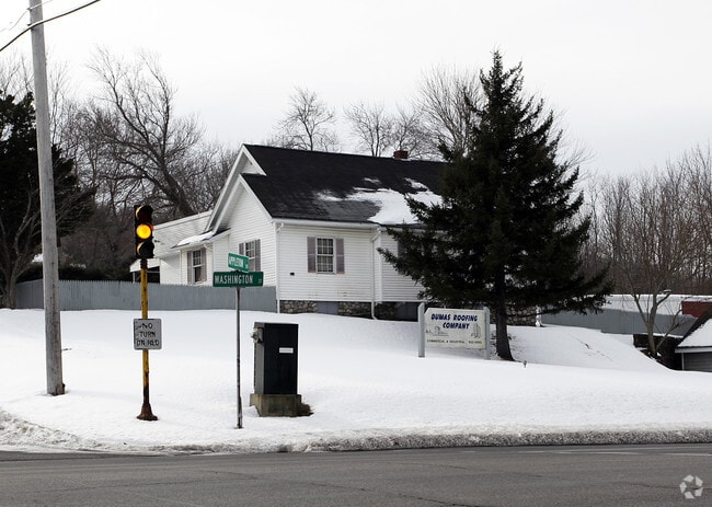
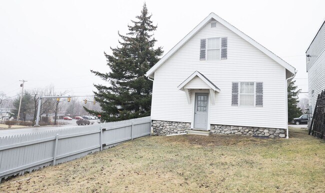
Property Record
28 Appleton Rd, Auburn, MA 01501
NEARBY LISTINGS FOR SALE OR LEASE
Property Detail
28 Appleton Rd
Worcester, MA
Worcester
AUBU-000060-000000-000072
Massachusetts
Commercialnec
0.37 AC
X
Outlying Worcester
25027C0811F
Boston
DEMOGRAPHICS near 28 Appleton Rd
1 Mile
3 Mile
5 Mile
2024 Total Population
2,024
17,057
64,627
2029 Population
2,024
17,035
64,184
Pop Growth 2024-2029
0.00%
(0.13%)
(0.69%)
Average Age
44
44
41
2024 Total Households
769
6,922
24,513
HH Growth 2024-2029
0.00%
(0.16%)
(0.69%)
Median Household Inc
$114,367
$103,229
$86,865
Avg Household Size
2.50
2.40
2.40
2024 Avg HH Vehicles
2.00
2.00
2.00
Median Home Value
$376,865
$346,728
$336,225
Median Year Built
1968
1965
1961
Nearby Places
Map Layers
Map Styles
 Street
 Aerial
- Restaurants
- Banks
- Shops
- Fitness
- Groceries
PUBLIC TRANSPORTATION
COMMUTER RAIL
DRIVE
WALK
Distance
11 min
7.6 mi
Worcester (Framingham/Worcester Line - Massachusetts Bay Transportation Authority Commuter Rail (Purple Line))
DRIVE
WALK
Distance
Worcester (Framingham/Worcester Line - Massachusetts Bay Transportation Authority Commuter Rail (Purple Line))
12 min
7.9 mi
AIRPORT
Worcester Regional
DRIVE
WALK
Distance
Worcester Regional
19 min
8.6 mi
Rhode Island Tf Green International
DRIVE
WALK
Distance
Rhode Island Tf Green International
66 min
48.8 mi
Freight Ports
Port of Boston
DRIVE
WALK
Distance
Port of Boston
63 min
47.9 mi
SALE & LEASE HISTORY
LISTING DATE
SALE/LEASE

Jan 26, 2017
For Sale
Apr 05, 2022
For Sale
Nearby Properties
Address
Land Use
TOTAL SIZE
Lot Size
Zoning
Address
Land Use
TOTAL SIZE
Lot Size
Zoning
164,378 SF
21.40 AC
Address
Land Use
TOTAL SIZE
Lot Size
Zoning
118,112 SF
6.54 AC
Address
Land Use
TOTAL SIZE
Lot Size
Zoning
41.84 AC
Address
Land Use
TOTAL SIZE
Lot Size
Zoning
36.67 AC
Address
Land Use
TOTAL SIZE
Lot Size
Zoning
92,604 SF
1 AC
Address
Land Use
TOTAL SIZE
Lot Size
Zoning
210,001 SF
13.14 AC
Address
Land Use
TOTAL SIZE
Lot Size
Zoning
267,600 SF
45.87 AC
R2
Address
Land Use
TOTAL SIZE
Lot Size
Zoning
15.60 AC
R2
Address
Land Use
TOTAL SIZE
Lot Size
Zoning
21.72 AC
Address
Land Use
TOTAL SIZE
Lot Size
Zoning
116,919 SF
17.60 AC
Address
Land Use
TOTAL SIZE
Lot Size
Zoning
42.81 AC
Address
Land Use
TOTAL SIZE
Lot Size
Zoning
107,484 SF
11.70 AC
Address
Land Use
TOTAL SIZE
Lot Size
Zoning
56,190 SF
12.90 AC
Address
Land Use
TOTAL SIZE
Lot Size
Zoning
145,401 SF
23.20 AC
GB
Address
Land Use
TOTAL SIZE
Lot Size
Zoning
175,701 SF
25.85 AC
HB2
Address
Land Use
TOTAL SIZE
Lot Size
Zoning
40,174 SF
5.20 AC
Address
Land Use
TOTAL SIZE
Lot Size
Zoning
11.30 AC
Address
Land Use
TOTAL SIZE
Lot Size
Zoning
109,380 SF
27.60 AC
R2
Address
Land Use
TOTAL SIZE
Lot Size
Zoning
11.11 AC
Address
Land Use
TOTAL SIZE
Lot Size
Zoning
100,640 SF
7.30 AC
Address
Land Use
TOTAL SIZE
Lot Size
Zoning
7,000 SF
20.84 AC
I
Address
Land Use
TOTAL SIZE
Lot Size
Zoning
53,096 SF
5.60 AC
Address
Land Use
TOTAL SIZE
Lot Size
Zoning
50,065 SF
8.65 AC
R3
Address
Land Use
TOTAL SIZE
Lot Size
Zoning
5.80 AC
Address
Land Use
TOTAL SIZE
Lot Size
Zoning
104,482 SF
8.30 AC
Address
Land Use
TOTAL SIZE
Lot Size
Zoning
92,954 SF
5.10 AC
Address
Land Use
TOTAL SIZE
Lot Size
Zoning
3.90 AC
Address
Land Use
TOTAL SIZE
Lot Size
Zoning
10.02 AC
RES
Address
Land Use
TOTAL SIZE
Lot Size
Zoning
6.03 AC
Address
Land Use
TOTAL SIZE
Lot Size
Zoning
2.60 AC
The World's #1 Commercial Real Estate Marketplace
Connect with us
© 2026 CoStar Group
The information above has been obtained from sources believed reliable. While we do not doubt its accuracy we have not verified it and make no guarantee, warranty or representation about it. It is your responsibility to independently confirm its accuracy and completeness. Any projections, opinions, assumptions, or estimates used are for example only and do not represent the current or future performance of the property. The value of this transaction to you depends on tax and other factors which should be evaluated by your tax, financial, and legal advisors. You and your advisors should conduct a careful, independent investigation of the property to determine to your satisfaction the suitability of the property for your needs.