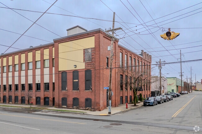
Property Record
28 Appleton St, Holyoke, MA 01040

Property Detail
28 Appleton St
HOLY-000032-000001-000001
Hampden
Commercialnec
Massachusetts
IG
1
B and X Area of moderate flood hazard, usually the area between the limits of the 100-year and 500-year floods.
1.83 AC
2024
Hampden County
2025
Hartford
811500
Springfield, MA
NEARBY LISTINGS FOR SALE OR LEASE
DEMOGRAPHICS near 28 Appleton St
1 mile
3 mile
5 mile
2025 Total Population
15,048
94,886
152,656
2030 Population
15,215
95,374
152,973
Pop Growth 2025-2030
+ 1.11%
+ 0.51%
+ 0.21%
Average Age
36
41
41
2025 Total Households
6,027
40,050
63,142
HH Growth 2025-2030
+ 1.18%
+ 0.58%
+ 0.25%
Median Household Inc
$34,643
$59,929
$64,431
Avg Household Size
2.40
2.30
2.30
2025 Avg HH Vehicles
1.00
1.00
2.00
Median Home Value
$263,450
$277,677
$285,370
Median Year Built
1949
1962
1961
Nearby Places
Map Layers
Map Styles
 Street
 Aerial
Transit
 Traffic
 Biking
Places
Listings with unknown addresses are not visible on the map
- Restaurants
- Banks
- Shops
- Fitness
- Groceries
PUBLIC TRANSPORTATION
COMMUTER RAIL
Drive
Walk
Distance
2 min
11 min
0.6 mi
Drive
Walk
Distance
13 min
8.0 mi
AIRPORT
Bradley International
Drive
Walk
Distance
Bradley International
42 min
20.7 mi
SALE & LEASE HISTORY
LISTING DATE
SALE/LEASE

Jul 31, 2023
For Sale
Jan 30, 2023
For Lease
Jan 13, 2022
For Lease
Aug 23, 2022
For Lease
Apr 02, 2025
For Sale
Nearby Properties
Address
Land Use
TOTAL SIZE
Lot Size
Zoning
Address
Land Use
TOTAL SIZE
Lot Size
Zoning
50.97 AC
BH
Address
Land Use
TOTAL SIZE
Lot Size
Zoning
22.15 AC
R-1A
Address
Land Use
TOTAL SIZE
Lot Size
Zoning
21.80 AC
106
Address
Land Use
TOTAL SIZE
Lot Size
Zoning
29.88 AC
105
Address
Land Use
TOTAL SIZE
Lot Size
Zoning
189,022 SF
10.62 AC
RA
Address
Land Use
TOTAL SIZE
Lot Size
Zoning
22.77 AC
111A
Address
Land Use
TOTAL SIZE
Lot Size
Zoning
138,504 SF
13.18 AC
RO
Address
Land Use
TOTAL SIZE
Lot Size
Zoning
17.72 AC
R-2
Address
Land Use
TOTAL SIZE
Lot Size
Zoning
171,241 SF
18.94 AC
106
Address
Land Use
TOTAL SIZE
Lot Size
Zoning
30.45 AC
106
Address
Land Use
TOTAL SIZE
Lot Size
Zoning
223,390 SF
13.83 AC
111A
Address
Land Use
TOTAL SIZE
Lot Size
Zoning
26.68 AC
110
Address
Land Use
TOTAL SIZE
Lot Size
Zoning
12.90 AC
IP
Address
Land Use
TOTAL SIZE
Lot Size
Zoning
2.41 AC
DR
Address
Land Use
TOTAL SIZE
Lot Size
Zoning
17.64 AC
105
Address
Land Use
TOTAL SIZE
Lot Size
Zoning
4.04 AC
107
Address
Land Use
TOTAL SIZE
Lot Size
Zoning
257,179 SF
22.84 AC
110
Address
Land Use
TOTAL SIZE
Lot Size
Zoning
8.16 AC
RM40
Address
Land Use
TOTAL SIZE
Lot Size
Zoning
16.38 AC
RA
Address
Land Use
TOTAL SIZE
Lot Size
Zoning
81.65 AC
110
Address
Land Use
TOTAL SIZE
Lot Size
Zoning
72,239 SF
13.87 AC
R-1A
Address
Land Use
TOTAL SIZE
Lot Size
Zoning
320,639 SF
14.16 AC
110
Address
Land Use
TOTAL SIZE
Lot Size
Zoning
23,111 SF
1.43 AC
IA
Address
Land Use
TOTAL SIZE
Lot Size
Zoning
138,289 SF
22.79 AC
IG
Address
Land Use
TOTAL SIZE
Lot Size
Zoning
4.66 AC
105
Address
Land Use
TOTAL SIZE
Lot Size
Zoning
196,705 SF
21.45 AC
RM20
Address
Land Use
TOTAL SIZE
Lot Size
Zoning
201,410 SF
13.16 AC
RM20
Address
Land Use
TOTAL SIZE
Lot Size
Zoning
191,133 SF
12.28 AC
RM-2
Address
Land Use
TOTAL SIZE
Lot Size
Zoning
62,808 SF
7.60 AC
R-1
Address
Land Use
TOTAL SIZE
Lot Size
Zoning
26.98 AC
BG
The World's #1 Commercial Real Estate Marketplace
Connect with us
© 2026 CoStar Group
The information above has been obtained from sources believed reliable. While we do not doubt its accuracy we have not verified it and make no guarantee, warranty or representation about it. It is your responsibility to independently confirm its accuracy and completeness. Any projections, opinions, assumptions, or estimates used are for example only and do not represent the current or future performance of the property. The value of this transaction to you depends on tax and other factors which should be evaluated by your tax, financial, and legal advisors. You and your advisors should conduct a careful, independent investigation of the property to determine to your satisfaction the suitability of the property for your needs.