Property Record
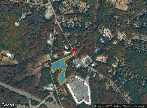
28 Burnt Tavern Rd, Millstone Township, NJ 08510

NEARBY LISTINGS FOR SALE OR LEASE
Property Detail
28 Burnt Tavern Rd
New York-Jersey City-White Plains, NY-NJ
FACILITY NAME: 11012018
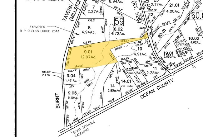
33-00059-0000-00009-01
Monmouth
Governmentalpublicusegeneral
New Jersey
AE
9.1
34025C0266F
12.97 AC
0
Western Monmouth
2025
Northern New Jersey
812502
DEMOGRAPHICS near 28 Burnt Tavern Rd
1 Mile
3 Mile
5 Mile
2024 Total Population
891
8,894
21,797
2029 Population
914
9,083
22,419
Pop Growth 2024-2029
+ 2.58%
+ 2.13%
+ 2.85%
Average Age
39
40
40
2024 Total Households
272
2,800
7,302
HH Growth 2024-2029
+ 1.84%
+ 1.64%
+ 2.74%
Median Household Inc
$158,750
$157,900
$133,239
Avg Household Size
3.10
3.10
2.90
2024 Avg HH Vehicles
3.00
3.00
3.00
Median Home Value
$557,554
$579,123
$499,566
Median Year Built
1991
1991
1990
Nearby Places
Map Layers
Map Styles
 Street
 Aerial
- Restaurants
- Banks
- Shops
- Fitness
- Groceries
PUBLIC TRANSPORTATION
AIRPORT
Trenton Mercer
DRIVE
WALK
Distance
Trenton Mercer
38 min
26.8 mi
Freight Ports
New York Container Terminal
DRIVE
WALK
Distance
New York Container Terminal
57 min
42.2 mi
SALE & LEASE HISTORY
LISTING DATE
SALE/LEASE

Sep 24, 2016
For Sale
Nearby Properties
Address
Land Use
TOTAL SIZE
Lot Size
Zoning
Address
Land Use
TOTAL SIZE
Lot Size
Zoning
908.18 AC
CR-1
Address
Land Use
TOTAL SIZE
Lot Size
Zoning
39.08 AC
HCMU
Address
Land Use
TOTAL SIZE
Lot Size
Zoning
55.83 AC
HC
Address
Land Use
TOTAL SIZE
Lot Size
Zoning
33.61 AC
HCMU
Address
Land Use
TOTAL SIZE
Lot Size
Zoning
30.60 AC
PFE
Address
Land Use
TOTAL SIZE
Lot Size
Zoning
2,420 SF
41.72 AC
MHP
Address
Land Use
TOTAL SIZE
Lot Size
Zoning
88.35 AC
R-E
Address
Land Use
TOTAL SIZE
Lot Size
Zoning
86.85 AC
R-E
Address
Land Use
TOTAL SIZE
Lot Size
Zoning
17.57 AC
PFE
Address
Land Use
TOTAL SIZE
Lot Size
Zoning
25.47 AC
HC
Address
Land Use
TOTAL SIZE
Lot Size
Zoning
69.27 AC
R-E
Address
Land Use
TOTAL SIZE
Lot Size
Zoning
78.40 AC
HC
Address
Land Use
TOTAL SIZE
Lot Size
Zoning
44.29 AC
R-E
Address
Land Use
TOTAL SIZE
Lot Size
Zoning
866 SF
9.32 AC
LC
Address
Land Use
TOTAL SIZE
Lot Size
Zoning
43.76 AC
R-E
Address
Land Use
TOTAL SIZE
Lot Size
Zoning
17.18 AC
HC
Address
Land Use
TOTAL SIZE
Lot Size
Zoning
39.50 AC
R-E
Address
Land Use
TOTAL SIZE
Lot Size
Zoning
39.36 AC
R-40
Address
Land Use
TOTAL SIZE
Lot Size
Zoning
38.06 AC
R-E
Address
Land Use
TOTAL SIZE
Lot Size
Zoning
6.08 AC
BP
Address
Land Use
TOTAL SIZE
Lot Size
Zoning
1,080 SF
30.22 AC
SF80
Address
Land Use
TOTAL SIZE
Lot Size
Zoning
37.17 AC
R-E
Address
Land Use
TOTAL SIZE
Lot Size
Zoning
19.90 AC
LM
Address
Land Use
TOTAL SIZE
Lot Size
Zoning
6.14 AC
HC
Address
Land Use
TOTAL SIZE
Lot Size
Zoning
952.97 AC
ROS
Address
Land Use
TOTAL SIZE
Lot Size
Zoning
34.28 AC
R-E
Address
Land Use
TOTAL SIZE
Lot Size
Zoning
34.28 AC
R-E
Address
Land Use
TOTAL SIZE
Lot Size
Zoning
15.49 AC
SF80
Address
Land Use
TOTAL SIZE
Lot Size
Zoning
34 AC
R-E
Address
Land Use
TOTAL SIZE
Lot Size
Zoning
2 AC
HC
The World's #1 Commercial Real Estate Marketplace
Connect with us
© 2025 CoStar Group
The information above has been obtained from sources believed reliable. While we do not doubt its accuracy we have not verified it and make no guarantee, warranty or representation about it. It is your responsibility to independently confirm its accuracy and completeness. Any projections, opinions, assumptions, or estimates used are for example only and do not represent the current or future performance of the property. The value of this transaction to you depends on tax and other factors which should be evaluated by your tax, financial, and legal advisors. You and your advisors should conduct a careful, independent investigation of the property to determine to your satisfaction the suitability of the property for your needs.