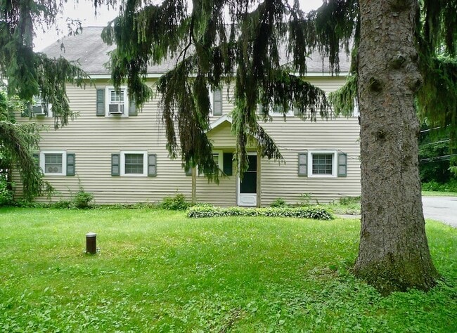
Property Record
28 Dug Rd, New Paltz, NY 12561
NEARBY LISTINGS FOR SALE OR LEASE
Property Detail
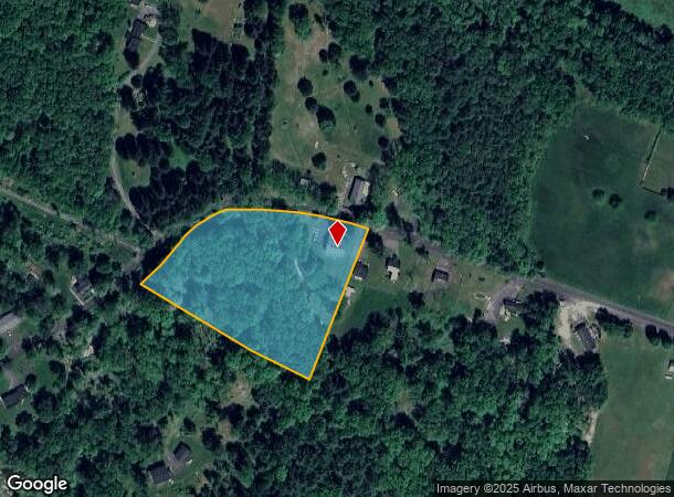
28 Dug Rd
Apartment
Ulster
AE
New York
36111C0615E
47.000
2025
3.90 AC
2024
Other Market Areas
953300
Kingston, NY
5,737 SF
3889-078.003-0003-047.000-0000
DEMOGRAPHICS near 28 Dug Rd
1 Mile
3 Mile
5 Mile
2024 Total Population
401
11,605
22,135
2029 Population
395
11,558
22,026
Pop Growth 2024-2029
(1.50%)
(0.40%)
(0.49%)
Average Age
45
37
41
2024 Total Households
161
3,806
8,040
HH Growth 2024-2029
(1.86%)
(0.74%)
(0.66%)
Median Household Inc
$126,389
$78,657
$88,214
Avg Household Size
2.50
2.20
2.30
2024 Avg HH Vehicles
2.00
2.00
2.00
Median Home Value
$469,090
$400,514
$365,849
Median Year Built
1974
1972
1970
Nearby Places
- Restaurants
- Banks
- Shops
- Fitness
- Groceries
PUBLIC TRANSPORTATION
AIRPORT
New York Stewart International
DRIVE
WALK
Distance
New York Stewart International
41 min
26.2 mi
Freight Ports
Albany, NY Port
DRIVE
WALK
Distance
Albany, NY Port
90 min
65.8 mi
SALE & LEASE HISTORY
LISTING DATE
SALE/LEASE

Jun 14, 2021
For Sale
Jul 13, 2021
For Sale
Nearby Properties
Address
Land Use
TOTAL SIZE
Lot Size
Zoning
Address
Land Use
TOTAL SIZE
Lot Size
Zoning
53,355 SF
189.30 AC
16
Address
Land Use
TOTAL SIZE
Lot Size
Zoning
80,863 SF
17.30 AC
R2
Address
Land Use
TOTAL SIZE
Lot Size
Zoning
68,100 SF
14.20 AC
B2
Address
Land Use
TOTAL SIZE
Lot Size
Zoning
55,616 SF
10.90 AC
R3
Address
Land Use
TOTAL SIZE
Lot Size
Zoning
14,400 SF
11.50 AC
R2
Address
Land Use
TOTAL SIZE
Lot Size
Zoning
Address
Land Use
TOTAL SIZE
Lot Size
Zoning
8,932 SF
6.72 AC
R2
Address
Land Use
TOTAL SIZE
Lot Size
Zoning
1,568 SF
74.50 AC
RR1.5
Address
Land Use
TOTAL SIZE
Lot Size
Zoning
64,761 SF
18 AC
R1
Address
Land Use
TOTAL SIZE
Lot Size
Zoning
9,672 SF
8.58 AC
RV
Address
Land Use
TOTAL SIZE
Lot Size
Zoning
10,206 SF
10.60 AC
I1
Address
Land Use
TOTAL SIZE
Lot Size
Zoning
2,276 SF
10.60 AC
I1
Address
Land Use
TOTAL SIZE
Lot Size
Zoning
63,280 SF
1.40 AC
B3
Address
Land Use
TOTAL SIZE
Lot Size
Zoning
32,296 SF
16.30 AC
B2
Address
Land Use
TOTAL SIZE
Lot Size
Zoning
784 SF
18.70 AC
F
Address
Land Use
TOTAL SIZE
Lot Size
Zoning
54,884 SF
2.40 AC
I1
Address
Land Use
TOTAL SIZE
Lot Size
Zoning
586 SF
836.90 AC
10
Address
Land Use
TOTAL SIZE
Lot Size
Zoning
9,162 SF
5.40 AC
R3
Address
Land Use
TOTAL SIZE
Lot Size
Zoning
11,168 SF
1.67 AC
R2
Address
Land Use
TOTAL SIZE
Lot Size
Zoning
48,520 SF
5.40 AC
B2
Address
Land Use
TOTAL SIZE
Lot Size
Zoning
33,000 SF
118.30 AC
R5
Address
Land Use
TOTAL SIZE
Lot Size
Zoning
1,365 SF
505 AC
A3
Address
Land Use
TOTAL SIZE
Lot Size
Zoning
37,434 SF
2.60 AC
R2
Address
Land Use
TOTAL SIZE
Lot Size
Zoning
62,220 SF
7.30 AC
B2
Address
Land Use
TOTAL SIZE
Lot Size
Zoning
26,447 SF
1.48 AC
I1
Address
Land Use
TOTAL SIZE
Lot Size
Zoning
15,156 SF
1.10 AC
B2
Address
Land Use
TOTAL SIZE
Lot Size
Zoning
41.90 AC
RV
Address
Land Use
TOTAL SIZE
Lot Size
Zoning
Address
Land Use
TOTAL SIZE
Lot Size
Zoning
16,624 SF
1.10 AC
B1
Address
Land Use
TOTAL SIZE
Lot Size
Zoning
34,106 SF
3.79 AC
B2
The World's #1 Commercial Real Estate Marketplace
Connect with us
© 2025 CoStar Group
The information above has been obtained from sources believed reliable. While we do not doubt its accuracy we have not verified it and make no guarantee, warranty or representation about it. It is your responsibility to independently confirm its accuracy and completeness. Any projections, opinions, assumptions, or estimates used are for example only and do not represent the current or future performance of the property. The value of this transaction to you depends on tax and other factors which should be evaluated by your tax, financial, and legal advisors. You and your advisors should conduct a careful, independent investigation of the property to determine to your satisfaction the suitability of the property for your needs.