Property Record
28 E Bel Air Ave, Aberdeen, MD 21001


Save to a Folder
{{folder.Name}}
{{folder.ListingIds.length}} Properties
{{folder.ListingIds.length}} Property
Create a New Folder
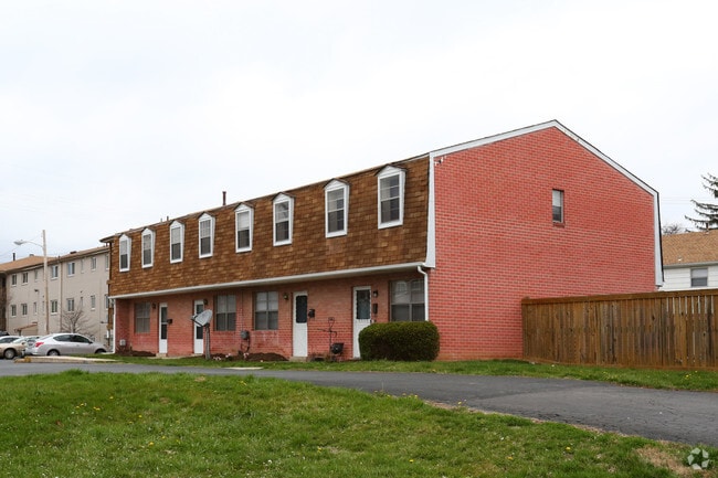
Property Detail
28 E Bel Air Ave
02-029936
6.47 ACRES E BEL AIR AVENUE ABERDEEN VILG APTS
Multifamilydwelling
Harford
R3
Maryland
B and X Area of moderate flood hazard, usually the area between the limits of the 100-year and 500-year floods.
6.47 AC
2025
Outlying Harford County
2025
Baltimore
302802
Baltimore-Columbia-Towson, MD
103,910 SF
NEARBY LISTINGS FOR SALE OR LEASE
-
-
View all Aberdeen listings for sale on LoopNet.com
DEMOGRAPHICS near 28 E Bel Air Ave
1 mile
3 mile
5 mile
2025 Total Population
9,510
26,893
53,117
2030 Population
9,753
27,665
54,466
Pop Growth 2025-2030
+ 2.56%
+ 2.87%
+ 2.54%
Average Age
38
40
41
2025 Total Households
3,682
10,681
21,453
HH Growth 2025-2030
+ 2.55%
+ 2.83%
+ 2.58%
Median Household Inc
$62,791
$82,497
$94,117
Avg Household Size
2.50
2.50
2.40
2025 Avg HH Vehicles
2.00
2.00
2.00
Median Home Value
$203,417
$289,955
$321,577
Median Year Built
1968
1982
1988
Nearby Places
Map Layers
Map Styles
 Street
 Aerial
Layers
 Traffic
 Biking
Places
Listings with unknown addresses are not visible on the map
- Restaurants
- Banks
- Shops
- Fitness
- Groceries
PUBLIC TRANSPORTATION
COMMUTER RAIL
Aberdeen Amtrak Station (Commuter Rail - Amtrak, Northeast Regional - Amtrak, PENN - WASHINGTON - Amtrak)
Drive
Walk
Distance
Aberdeen Amtrak Station (Commuter Rail - Amtrak, Northeast Regional - Amtrak, PENN - WASHINGTON - Amtrak)
2 min
14 min
0.7 mi
Perryville Marc (PENN - WASHINGTON - Maryland Transit Administration)
Drive
Walk
Distance
Perryville Marc (PENN - WASHINGTON - Maryland Transit Administration)
12 min
7.7 mi
Freight Ports
Port of Baltimore
Drive
Walk
Distance
Port of Baltimore
46 min
34.4 mi
SALE & LEASE HISTORY
LISTING DATE
SALE/LEASE

Oct 01, 2018
For Sale
Nearby Properties
Address
Land Use
TOTAL SIZE
Lot Size
Zoning
Address
Land Use
TOTAL SIZE
Lot Size
Zoning
860,000 SF
97.70 AC
CI GI
Address
Land Use
TOTAL SIZE
Lot Size
Zoning
31,008 SF
10.77 AC
Address
Land Use
TOTAL SIZE
Lot Size
Zoning
197,582 SF
63.43 AC
R1
Address
Land Use
TOTAL SIZE
Lot Size
Zoning
257,922 SF
34.94 AC
B3
Address
Land Use
TOTAL SIZE
Lot Size
Zoning
50,732 SF
10.91 AC
M1
Address
Land Use
TOTAL SIZE
Lot Size
Zoning
137,040 SF
9.38 AC
B3
Address
Land Use
TOTAL SIZE
Lot Size
Zoning
623,017 SF
57.87 AC
GI
Address
Land Use
TOTAL SIZE
Lot Size
Zoning
499,950 SF
42.06 AC
M1
Address
Land Use
TOTAL SIZE
Lot Size
Zoning
700,000 SF
50.16 AC
LI
Address
Land Use
TOTAL SIZE
Lot Size
Zoning
206,732 SF
57.23 AC
M2
Address
Land Use
TOTAL SIZE
Lot Size
Zoning
399,600 SF
23.91 AC
M1
Address
Land Use
TOTAL SIZE
Lot Size
Zoning
185,444 SF
30.12 AC
M2
Address
Land Use
TOTAL SIZE
Lot Size
Zoning
127,478 SF
41.72 AC
GI
Address
Land Use
TOTAL SIZE
Lot Size
Zoning
180,905 SF
26.46 AC
R2
Address
Land Use
TOTAL SIZE
Lot Size
Zoning
629,898 SF
41.28 AC
M2
Address
Land Use
TOTAL SIZE
Lot Size
Zoning
37,951 SF
148.22 AC
AG
Address
Land Use
TOTAL SIZE
Lot Size
Zoning
2,600 SF
44.09 AC
M2
Address
Land Use
TOTAL SIZE
Lot Size
Zoning
132,676 SF
4.40 AC
M1
Address
Land Use
TOTAL SIZE
Lot Size
Zoning
162,500 SF
20.14 AC
GI
Address
Land Use
TOTAL SIZE
Lot Size
Zoning
32,873 SF
33.80 AC
M1
Address
Land Use
TOTAL SIZE
Lot Size
Zoning
394,800 SF
129.36 AC
GI
Address
Land Use
TOTAL SIZE
Lot Size
Zoning
644,292 SF
46.97 AC
GI
Address
Land Use
TOTAL SIZE
Lot Size
Zoning
13,376 SF
14.49 AC
R1
Address
Land Use
TOTAL SIZE
Lot Size
Zoning
29,700 SF
9.51 AC
C1
Address
Land Use
TOTAL SIZE
Lot Size
Zoning
249,200 SF
28.82 AC
GI
Address
Land Use
TOTAL SIZE
Lot Size
Zoning
346,820 SF
25.12 AC
I
Address
Land Use
TOTAL SIZE
Lot Size
Zoning
187,200 SF
13.36 AC
R3
Address
Land Use
TOTAL SIZE
Lot Size
Zoning
207,288 SF
19.69 AC
M2
Address
Land Use
TOTAL SIZE
Lot Size
Zoning
22,102 SF
3.74 AC
B3
Address
Land Use
TOTAL SIZE
Lot Size
Zoning
426,275 SF
21.17 AC
GI
The World's #1 Commercial Real Estate Marketplace
Connect with us
© 2026 CoStar Group
The information above has been obtained from sources believed reliable. While we do not doubt its accuracy we have not verified it and make no guarantee, warranty or representation about it. It is your responsibility to independently confirm its accuracy and completeness. Any projections, opinions, assumptions, or estimates used are for example only and do not represent the current or future performance of the property. The value of this transaction to you depends on tax and other factors which should be evaluated by your tax, financial, and legal advisors. You and your advisors should conduct a careful, independent investigation of the property to determine to your satisfaction the suitability of the property for your needs.