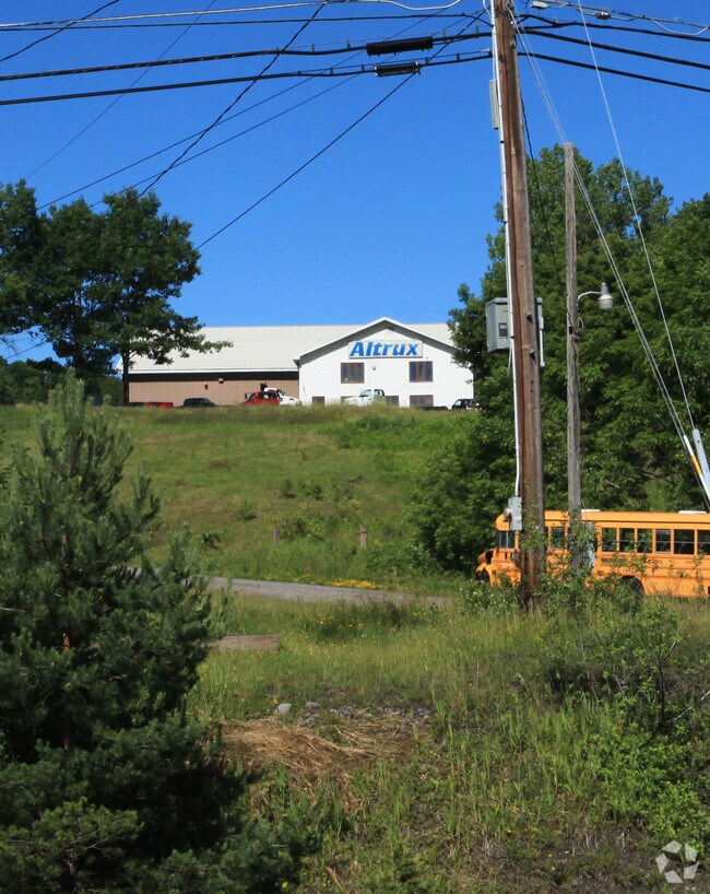
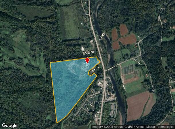
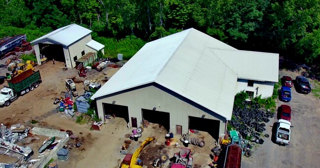
Property Record
28 E State Route 28 St, Herkimer, NY 13350

NEARBY LISTINGS FOR SALE OR LEASE
Property Detail
28 E State Route 28 St
Utica-Rome, NY
W 22 23-1 W1 6 22,23-1 BLD & S ADD L C
213089-113-003-0001-007-100-0000
Herkimer
Vehiclerentalsvehiclesales
New York
2025
7.100
2024
69.40 AC
011200
Herkimer County
8,586 SF
Utica/Rome
DEMOGRAPHICS near 28 E State Route 28 St
1 Mile
3 Mile
5 Mile
2024 Total Population
694
11,167
26,275
2029 Population
684
11,083
25,998
Pop Growth 2024-2029
(1.44%)
(0.75%)
(1.05%)
Average Age
45
42
42
2024 Total Households
283
4,684
11,123
HH Growth 2024-2029
(1.41%)
(0.66%)
(1.06%)
Median Household Inc
$71,062
$58,863
$60,304
Avg Household Size
2.30
2.10
2.20
2024 Avg HH Vehicles
2.00
2.00
2.00
Median Home Value
$105,634
$118,806
$104,089
Median Year Built
1949
1948
1948
Nearby Places
Map Layers
Map Styles
 Street
 Aerial
- Restaurants
- Banks
- Shops
- Fitness
- Groceries
SALE & LEASE HISTORY
LISTING DATE
SALE/LEASE

Sep 16, 2022
For Sale
Nearby Properties
Address
Land Use
TOTAL SIZE
Lot Size
Zoning
Address
Land Use
TOTAL SIZE
Lot Size
Zoning
93,840 SF
2.20 AC
C3
Address
Land Use
TOTAL SIZE
Lot Size
Zoning
151,309 SF
11.50 AC
R3
Address
Land Use
TOTAL SIZE
Lot Size
Zoning
90,636 SF
2.10 AC
C
Address
Land Use
TOTAL SIZE
Lot Size
Zoning
1 AC
GB
Address
Land Use
TOTAL SIZE
Lot Size
Zoning
208,087 SF
18.72 AC
C2
Address
Land Use
TOTAL SIZE
Lot Size
Zoning
122,210 SF
12.50 AC
I1
Address
Land Use
TOTAL SIZE
Lot Size
Zoning
221.80 AC
A
Address
Land Use
TOTAL SIZE
Lot Size
Zoning
139,863 SF
16.90 AC
Address
Land Use
TOTAL SIZE
Lot Size
Zoning
19,680 SF
1.10 AC
R3
Address
Land Use
TOTAL SIZE
Lot Size
Zoning
81,816 SF
1.50 AC
R3
Address
Land Use
TOTAL SIZE
Lot Size
Zoning
56,530 SF
10.50 AC
C1
Address
Land Use
TOTAL SIZE
Lot Size
Zoning
98,801 SF
59 AC
R2
Address
Land Use
TOTAL SIZE
Lot Size
Zoning
26,799 SF
1.50 AC
R3
Address
Land Use
TOTAL SIZE
Lot Size
Zoning
1,503 SF
3.49 AC
C
Address
Land Use
TOTAL SIZE
Lot Size
Zoning
2,662 SF
3.90 AC
C
Address
Land Use
TOTAL SIZE
Lot Size
Zoning
48,893 SF
1.50 AC
C
Address
Land Use
TOTAL SIZE
Lot Size
Zoning
14,841 SF
1.67 AC
C2
Address
Land Use
TOTAL SIZE
Lot Size
Zoning
19,500 SF
0.80 AC
R2
Address
Land Use
TOTAL SIZE
Lot Size
Zoning
18,050 SF
0.56 AC
C3
Address
Land Use
TOTAL SIZE
Lot Size
Zoning
19,142 SF
2.50 AC
C2
Address
Land Use
TOTAL SIZE
Lot Size
Zoning
159,334 SF
8.20 AC
Address
Land Use
TOTAL SIZE
Lot Size
Zoning
12,808 SF
5.10 AC
Address
Land Use
TOTAL SIZE
Lot Size
Zoning
12,484 SF
9 AC
C
Address
Land Use
TOTAL SIZE
Lot Size
Zoning
5,954 SF
0.48 AC
C1
Address
Land Use
TOTAL SIZE
Lot Size
Zoning
23,724 SF
1.70 AC
C05
Address
Land Use
TOTAL SIZE
Lot Size
Zoning
103,198 SF
5.10 AC
I1
Address
Land Use
TOTAL SIZE
Lot Size
Zoning
14.30 AC
I1
Address
Land Use
TOTAL SIZE
Lot Size
Zoning
10,800 SF
1.50 AC
C
Address
Land Use
TOTAL SIZE
Lot Size
Zoning
6,476 SF
0.47 AC
C1
Address
Land Use
TOTAL SIZE
Lot Size
Zoning
3,531 SF
6.80 AC
I1
The World's #1 Commercial Real Estate Marketplace
Connect with us
© 2026 CoStar Group
The information above has been obtained from sources believed reliable. While we do not doubt its accuracy we have not verified it and make no guarantee, warranty or representation about it. It is your responsibility to independently confirm its accuracy and completeness. Any projections, opinions, assumptions, or estimates used are for example only and do not represent the current or future performance of the property. The value of this transaction to you depends on tax and other factors which should be evaluated by your tax, financial, and legal advisors. You and your advisors should conduct a careful, independent investigation of the property to determine to your satisfaction the suitability of the property for your needs.