Property Record
28 Gilchrest Rd, Great Neck, NY 11021

Save to a Folder
{{folder.Name}}
{{folder.ListingIds.length}} Properties
{{folder.ListingIds.length}} Property
Create a New Folder
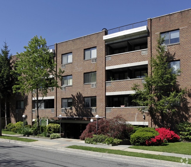
Property Detail
28 Gilchrest Rd
Nassau County-Suffolk County, NY
200 & 208-209 & 307 & 309
2213-02-190-00-0200-0
Nassau
Apartment
New York
B and X Area of moderate flood hazard, usually the area between the limits of the 100-year and 500-year floods.
200
2025
0.74 AC
2026
Great Neck Plaza
300700
Long Island (New York)
15,185 SF
NEARBY LISTINGS FOR SALE OR LEASE
DEMOGRAPHICS near 28 Gilchrest Rd
1 mile
3 mile
5 mile
2025 Total Population
26,466
121,380
465,695
2030 Population
27,006
122,112
462,479
Pop Growth 2025-2030
+ 2.04%
+ 0.60%
(0.69%)
Average Age
43
45
45
2025 Total Households
10,210
44,464
163,203
HH Growth 2025-2030
+ 2.06%
+ 0.35%
(1.03%)
Median Household Inc
$136,425
$135,118
$119,627
Avg Household Size
2.50
2.60
2.70
2025 Avg HH Vehicles
1.00
2.00
2.00
Median Home Value
$933,342
$1,000,795
$826,544
Median Year Built
1954
1957
1954
Nearby Places
Map Layers
Map Styles
 Street
 Aerial
Layers
 Traffic
 Biking
Places
Listings with unknown addresses are not visible on the map
- Restaurants
- Banks
- Shops
- Fitness
- Groceries
PUBLIC TRANSPORTATION
TRANSIT/SUBWAY
Great Neck Station (Port Washington Branch - Long Island Rail Road)
Drive
Walk
Distance
Great Neck Station (Port Washington Branch - Long Island Rail Road)
1 min
9 min
0.5 mi
COMMUTER RAIL
Great Neck Station (Port Washington Branch - Long Island Rail Road)
Drive
Walk
Distance
Great Neck Station (Port Washington Branch - Long Island Rail Road)
1 min
9 min
0.5 mi
Manhasset Station (Port Washington Branch - Long Island Rail Road)
Drive
Walk
Distance
Manhasset Station (Port Washington Branch - Long Island Rail Road)
5 min
1.9 mi
AIRPORT
LaGuardia
Drive
Walk
Distance
LaGuardia
22 min
12.2 mi
John F Kennedy International
Drive
Walk
Distance
John F Kennedy International
26 min
16.5 mi
Westchester County
Drive
Walk
Distance
Westchester County
51 min
31.5 mi
Freight Ports
NY - Red Hook Container Terminal
Drive
Walk
Distance
NY - Red Hook Container Terminal
34 min
20.3 mi
Nearby Properties
Address
Land Use
TOTAL SIZE
Lot Size
Zoning
Address
Land Use
TOTAL SIZE
Lot Size
Zoning
2,697,663 SF
3.46 AC
C5-3
Address
Land Use
TOTAL SIZE
Lot Size
Zoning
1,666,696 SF
1.87 AC
C52.5
Address
Land Use
TOTAL SIZE
Lot Size
Zoning
7,975 SF
133 AC
PARK
Address
Land Use
TOTAL SIZE
Lot Size
Zoning
1,667,567 SF
30 AC
R3-2
Address
Land Use
TOTAL SIZE
Lot Size
Zoning
421,996 SF
136.05 AC
R3-1
Address
Land Use
TOTAL SIZE
Lot Size
Zoning
198,298 SF
13.93 AC
C4-1
Address
Land Use
TOTAL SIZE
Lot Size
Zoning
186,843 SF
5.37 AC
R2A
Address
Land Use
TOTAL SIZE
Lot Size
Zoning
1,800 SF
54.60 AC
PARK
Address
Land Use
TOTAL SIZE
Lot Size
Zoning
32,000 SF
50 AC
PARK
Address
Land Use
TOTAL SIZE
Lot Size
Zoning
344,292 SF
12.56 AC
R4
Address
Land Use
TOTAL SIZE
Lot Size
Zoning
95.36 AC
PARK
Address
Land Use
TOTAL SIZE
Lot Size
Zoning
356,093 SF
3 AC
R3-2
Address
Land Use
TOTAL SIZE
Lot Size
Zoning
161,500 SF
3.44 AC
R3-2
Address
Land Use
TOTAL SIZE
Lot Size
Zoning
11.30 AC
PARK
Address
Land Use
TOTAL SIZE
Lot Size
Zoning
400 SF
25.80 AC
PARK
Address
Land Use
TOTAL SIZE
Lot Size
Zoning
1,856 SF
28.26 AC
PARK
Address
Land Use
TOTAL SIZE
Lot Size
Zoning
224,106 SF
6.72 AC
M1-1
Address
Land Use
TOTAL SIZE
Lot Size
Zoning
43,190 SF
6.64 AC
R3-2
Address
Land Use
TOTAL SIZE
Lot Size
Zoning
114,000 SF
4.36 AC
R3-2
Address
Land Use
TOTAL SIZE
Lot Size
Zoning
243,883 SF
3.51 AC
R6A
Address
Land Use
TOTAL SIZE
Lot Size
Zoning
38,014 SF
1.29 AC
M1-1
Address
Land Use
TOTAL SIZE
Lot Size
Zoning
7.82 AC
PARK
Address
Land Use
TOTAL SIZE
Lot Size
Zoning
89,197 SF
0.36 AC
R6A
Address
Land Use
TOTAL SIZE
Lot Size
Zoning
147,700 SF
1.67 AC
R5
Address
Land Use
TOTAL SIZE
Lot Size
Zoning
97,081 SF
2.08 AC
R4
Address
Land Use
TOTAL SIZE
Lot Size
Zoning
129,000 SF
1.76 AC
R2A
Address
Land Use
TOTAL SIZE
Lot Size
Zoning
147,700 SF
1.71 AC
R5
Address
Land Use
TOTAL SIZE
Lot Size
Zoning
45,440 SF
3.15 AC
R3-2
Address
Land Use
TOTAL SIZE
Lot Size
Zoning
75,600 SF
2.35 AC
R3-2
Address
Land Use
TOTAL SIZE
Lot Size
Zoning
65,412 SF
3.31 AC
R3-2
The World's #1 Commercial Real Estate Marketplace
Connect with us
© 2026 CoStar Group
The information above has been obtained from sources believed reliable. While we do not doubt its accuracy we have not verified it and make no guarantee, warranty or representation about it. It is your responsibility to independently confirm its accuracy and completeness. Any projections, opinions, assumptions, or estimates used are for example only and do not represent the current or future performance of the property. The value of this transaction to you depends on tax and other factors which should be evaluated by your tax, financial, and legal advisors. You and your advisors should conduct a careful, independent investigation of the property to determine to your satisfaction the suitability of the property for your needs.