Property Record
28 Hawaii Belt Rd, Honomu, HI 96728
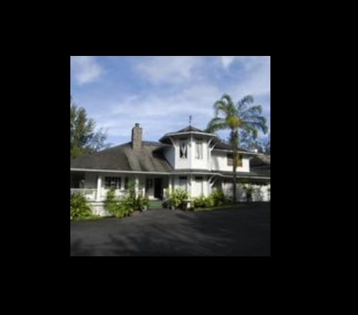

This Property Is For Sale
NEARBY LISTINGS FOR SALE OR LEASE
-
-
View all Honomu listings for sale on LoopNet.com
Property Detail
28 Hawaii Belt Rd
Hilo-Kailua, HI
Honomu
3-2-8-013-038-0000
LOT 2-A 3.405 AC POR GR 869 TOG/ESMT WITHIN LOT C-B TOG/ESMTS FOR WATERLINE PURP SUBJ/ESMTS
Agriculturalland
Hawaii
X
Hawaii
1551660700F
2-a
2024
3.41 AC
2025
Hawaii (Big Island)
020100
Hawaii
8,588 SF
DEMOGRAPHICS near 28 Hawaii Belt Rd
1 Mile
3 Mile
5 Mile
2024 Total Population
0
1,496
1,517
2029 Population
0
1,513
1,535
Pop Growth 2024-2029
0.00%
+ 1.14%
+ 1.19%
Average Age
0
40
40
2024 Total Households
0
488
496
HH Growth 2024-2029
0.00%
+ 0.61%
+ 0.60%
Median Household Inc
$0
$55,000
$55,428
Avg Household Size
.00
2.70
2.70
2024 Avg HH Vehicles
.00
2.00
2.00
Median Home Value
$0
$415,263
$416,667
Median Year Built
0
1976
1976
Nearby Places
Map Layers
Map Styles
 Street
 Aerial
- Restaurants
- Banks
- Shops
- Fitness
- Groceries
PUBLIC TRANSPORTATION
AIRPORT
Hilo International
DRIVE
WALK
Distance
Hilo International
25 min
14.3 mi
Freight Ports
Honolulu Harbor, Oahu
DRIVE
WALK
Distance
Honolulu Harbor, Oahu
1 min
204.3 mi
Nearby Properties
Address
Land Use
TOTAL SIZE
Lot Size
Zoning
Address
Land Use
TOTAL SIZE
Lot Size
Zoning
20,064 SF
25.57 AC
MG-5a
Address
Land Use
TOTAL SIZE
Lot Size
Zoning
9,019 SF
51.98 AC
A-20a
Address
Land Use
TOTAL SIZE
Lot Size
Zoning
8,736 SF
5.66 AC
RM-3.5
Address
Land Use
TOTAL SIZE
Lot Size
Zoning
7,510 SF
4.15 AC
A-20a
Address
Land Use
TOTAL SIZE
Lot Size
Zoning
26,426 SF
20.12 AC
A-20a
Address
Land Use
TOTAL SIZE
Lot Size
Zoning
7,144 SF
5 AC
RM-3.5
Address
Land Use
TOTAL SIZE
Lot Size
Zoning
8,560 SF
1.85 AC
A-20a
Address
Land Use
TOTAL SIZE
Lot Size
Zoning
11,568 SF
2.50 AC
RM-3.5
Address
Land Use
TOTAL SIZE
Lot Size
Zoning
10,488 SF
2.50 AC
RM-3.5
Address
Land Use
TOTAL SIZE
Lot Size
Zoning
6,410 SF
1.87 AC
A-20a
Address
Land Use
TOTAL SIZE
Lot Size
Zoning
6,800 SF
5.49 AC
CV-10
Address
Land Use
TOTAL SIZE
Lot Size
Zoning
5.75 AC
A-20a
Address
Land Use
TOTAL SIZE
Lot Size
Zoning
4,461 SF
1.97 AC
A-20a
Address
Land Use
TOTAL SIZE
Lot Size
Zoning
4,426 SF
4.01 AC
A-20a
Address
Land Use
TOTAL SIZE
Lot Size
Zoning
3,514 SF
1.94 AC
A-20a
Address
Land Use
TOTAL SIZE
Lot Size
Zoning
4,386 SF
5.75 AC
RS-10
Address
Land Use
TOTAL SIZE
Lot Size
Zoning
6,219 SF
25.58 AC
A-20a
Address
Land Use
TOTAL SIZE
Lot Size
Zoning
31.10 AC
A-20a
Address
Land Use
TOTAL SIZE
Lot Size
Zoning
2,543 SF
2.42 AC
A-20a
Address
Land Use
TOTAL SIZE
Lot Size
Zoning
3,305 SF
2.42 AC
A-20a
Address
Land Use
TOTAL SIZE
Lot Size
Zoning
3.18 AC
MG-5a
Address
Land Use
TOTAL SIZE
Lot Size
Zoning
3,537 SF
5.53 AC
RS-10
Address
Land Use
TOTAL SIZE
Lot Size
Zoning
4,306 SF
20 AC
A-10a
Address
Land Use
TOTAL SIZE
Lot Size
Zoning
2,816 SF
20.03 AC
A-20a
Address
Land Use
TOTAL SIZE
Lot Size
Zoning
3,411 SF
1.97 AC
A-20a
Address
Land Use
TOTAL SIZE
Lot Size
Zoning
1,922 SF
8.74 AC
A-20a
Address
Land Use
TOTAL SIZE
Lot Size
Zoning
4,172 SF
11.53 AC
A-10a
Address
Land Use
TOTAL SIZE
Lot Size
Zoning
3,343 SF
4.97 AC
A-10a
Address
Land Use
TOTAL SIZE
Lot Size
Zoning
2,683 SF
1.35 AC
A-20a
The World's #1 Commercial Real Estate Marketplace
Connect with us
© 2026 CoStar Group
The information above has been obtained from sources believed reliable. While we do not doubt its accuracy we have not verified it and make no guarantee, warranty or representation about it. It is your responsibility to independently confirm its accuracy and completeness. Any projections, opinions, assumptions, or estimates used are for example only and do not represent the current or future performance of the property. The value of this transaction to you depends on tax and other factors which should be evaluated by your tax, financial, and legal advisors. You and your advisors should conduct a careful, independent investigation of the property to determine to your satisfaction the suitability of the property for your needs.