Property Record
28 Hope St, Niantic, CT 06357
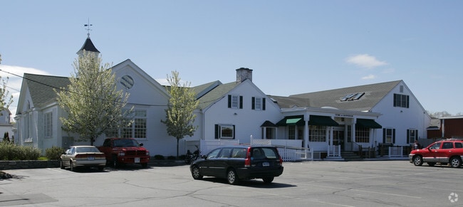
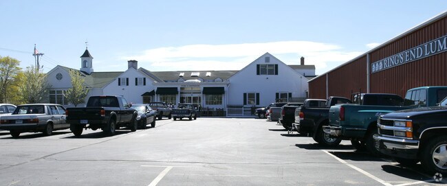
Property Detail
28 Hope St
ELYM-001201-000010
Southeastern Ct
Commercialnec
Connecticut
CB
6.58 AC
B and X Area of moderate flood hazard, usually the area between the limits of the 100-year and 500-year floods.
SW New London/East Lyme
2025
Hartford
2025
Norwich-New London-Willimantic, CT
870704
NEARBY LISTINGS FOR SALE OR LEASE
DEMOGRAPHICS near 28 Hope St
1 mile
3 mile
5 mile
2025 Total Population
3,527
21,004
50,284
2030 Population
3,648
21,636
51,307
Pop Growth 2025-2030
+ 3.43%
+ 3.01%
+ 2.03%
Average Age
50
48
44
2025 Total Households
1,775
9,258
21,304
HH Growth 2025-2030
+ 3.44%
+ 3.13%
+ 2.19%
Median Household Inc
$85,812
$103,058
$92,496
Avg Household Size
1.90
2.10
2.20
2025 Avg HH Vehicles
2.00
2.00
2.00
Median Home Value
$373,947
$391,434
$376,967
Median Year Built
1958
1967
1964
Nearby Places
Map Layers
Map Styles
 Street
 Aerial
Layers
 Traffic
 Biking
Places
Listings with unknown addresses are not visible on the map
- Restaurants
- Banks
- Shops
- Fitness
- Groceries
PUBLIC TRANSPORTATION
COMMUTER RAIL
New London (Shore Line East - Shore Line East)
Drive
Walk
Distance
New London (Shore Line East - Shore Line East)
13 min
6.2 mi
Freight Ports
Port of New Haven
Drive
Walk
Distance
Port of New Haven
53 min
39.4 mi
Nearby Properties
Address
Land Use
TOTAL SIZE
Lot Size
Zoning
Address
Land Use
TOTAL SIZE
Lot Size
Zoning
525.72 AC
I-G
Address
Land Use
TOTAL SIZE
Lot Size
Zoning
Address
Land Use
TOTAL SIZE
Lot Size
Zoning
66.17 AC
LI
Address
Land Use
TOTAL SIZE
Lot Size
Zoning
Address
Land Use
TOTAL SIZE
Lot Size
Zoning
1,256 SF
64.84 AC
R40
Address
Land Use
TOTAL SIZE
Lot Size
Zoning
617.95 AC
Address
Land Use
TOTAL SIZE
Lot Size
Zoning
68.87 AC
GDPP
Address
Land Use
TOTAL SIZE
Lot Size
Zoning
Address
Land Use
TOTAL SIZE
Lot Size
Zoning
68,244 SF
25.67 AC
R-40
Address
Land Use
TOTAL SIZE
Lot Size
Zoning
14.76 AC
CA
Address
Land Use
TOTAL SIZE
Lot Size
Zoning
62,878 SF
6.01 AC
CA
Address
Land Use
TOTAL SIZE
Lot Size
Zoning
55,906 SF
2.16 AC
CB
Address
Land Use
TOTAL SIZE
Lot Size
Zoning
Address
Land Use
TOTAL SIZE
Lot Size
Zoning
67,784 SF
5.53 AC
CA
Address
Land Use
TOTAL SIZE
Lot Size
Zoning
18.40 AC
R80
Address
Land Use
TOTAL SIZE
Lot Size
Zoning
10.79 AC
R40
Address
Land Use
TOTAL SIZE
Lot Size
Zoning
29,627 SF
20 AC
R-40
Address
Land Use
TOTAL SIZE
Lot Size
Zoning
59,162 SF
7.22 AC
R-40
Address
Land Use
TOTAL SIZE
Lot Size
Zoning
3.29 AC
CB
Address
Land Use
TOTAL SIZE
Lot Size
Zoning
56,568 SF
3.65 AC
LI
Address
Land Use
TOTAL SIZE
Lot Size
Zoning
29,830 SF
4.85 AC
LI
Address
Land Use
TOTAL SIZE
Lot Size
Zoning
57,298 SF
2.13 AC
CA
Address
Land Use
TOTAL SIZE
Lot Size
Zoning
36,657 SF
4.56 AC
CA
Address
Land Use
TOTAL SIZE
Lot Size
Zoning
2 AC
R40
Address
Land Use
TOTAL SIZE
Lot Size
Zoning
14,996 SF
1.10 AC
CA
Address
Land Use
TOTAL SIZE
Lot Size
Zoning
7.13 AC
R-40
Address
Land Use
TOTAL SIZE
Lot Size
Zoning
5.73 AC
CA
Address
Land Use
TOTAL SIZE
Lot Size
Zoning
5.13 AC
CM
Address
Land Use
TOTAL SIZE
Lot Size
Zoning
38,837 SF
2.15 AC
R40
Address
Land Use
TOTAL SIZE
Lot Size
Zoning
27,356 SF
0.95 AC
CB
The World's #1 Commercial Real Estate Marketplace
Connect with us
© 2026 CoStar Group
The information above has been obtained from sources believed reliable. While we do not doubt its accuracy we have not verified it and make no guarantee, warranty or representation about it. It is your responsibility to independently confirm its accuracy and completeness. Any projections, opinions, assumptions, or estimates used are for example only and do not represent the current or future performance of the property. The value of this transaction to you depends on tax and other factors which should be evaluated by your tax, financial, and legal advisors. You and your advisors should conduct a careful, independent investigation of the property to determine to your satisfaction the suitability of the property for your needs.