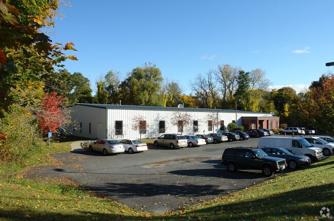
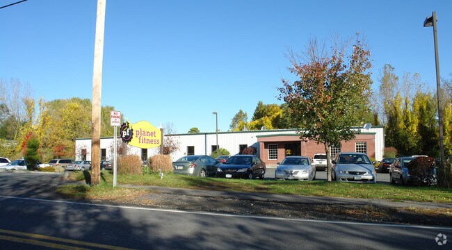
Property Record
28 Hudson Ave, Delmar, NY 12054

NEARBY LISTINGS FOR SALE OR LEASE
Property Detail
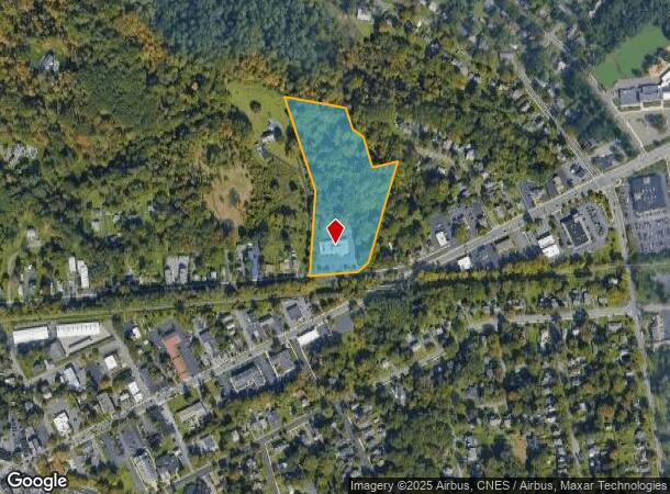
28 Hudson Ave
Albany-Schenectady-Troy, NY
Delmar
012200-085-012-0002-026-000-0000
HEALTH & FITNESS CENTER DELMAR
Gymhealthspa
Albany
X
New York
36001C0189D
26.000
2025
7.20 AC
2024
W Outer Albany County
014100
Albany/Schenectady/Troy
10,236 SF
DEMOGRAPHICS near 28 Hudson Ave
1 Mile
3 Mile
5 Mile
2024 Total Population
7,305
52,013
148,851
2029 Population
7,242
51,438
147,341
Pop Growth 2024-2029
(0.86%)
(1.11%)
(1.01%)
Average Age
44
42
38
2024 Total Households
2,973
22,104
62,363
HH Growth 2024-2029
(0.84%)
(1.12%)
(1.02%)
Median Household Inc
$107,001
$91,791
$66,798
Avg Household Size
2.30
2.30
2.10
2024 Avg HH Vehicles
2.00
2.00
1.00
Median Home Value
$291,950
$272,263
$251,021
Median Year Built
1952
1962
1956
Nearby Places
- Restaurants
- Banks
- Shops
- Fitness
- Groceries
PUBLIC TRANSPORTATION
COMMUTER RAIL
DRIVE
WALK
Distance
13 min
5.5 mi
AIRPORT
Albany International
DRIVE
WALK
Distance
Albany International
28 min
15.8 mi
Freight Ports
Albany, NY Port
DRIVE
WALK
Distance
Albany, NY Port
11 min
5.0 mi
SALE & LEASE HISTORY
LISTING DATE
SALE/LEASE

Mar 15, 2018
For Lease
Nearby Properties
Address
Land Use
TOTAL SIZE
Lot Size
Zoning
Address
Land Use
TOTAL SIZE
Lot Size
Zoning
502,950 SF
12.50 AC
CO
Address
Land Use
TOTAL SIZE
Lot Size
Zoning
133,984 SF
205.20 AC
C2
Address
Land Use
TOTAL SIZE
Lot Size
Zoning
197,169 SF
5 AC
CO
Address
Land Use
TOTAL SIZE
Lot Size
Zoning
9,208 SF
290.80 AC
LC
Address
Land Use
TOTAL SIZE
Lot Size
Zoning
191.95 AC
LC
Address
Land Use
TOTAL SIZE
Lot Size
Zoning
12,660 SF
15.60 AC
CO
Address
Land Use
TOTAL SIZE
Lot Size
Zoning
5,248 SF
200.90 AC
LC
Address
Land Use
TOTAL SIZE
Lot Size
Zoning
78,458 SF
28.70 AC
R1B
Address
Land Use
TOTAL SIZE
Lot Size
Zoning
441,152 SF
3.32 AC
CO
Address
Land Use
TOTAL SIZE
Lot Size
Zoning
198,884 SF
5.35 AC
CO
Address
Land Use
TOTAL SIZE
Lot Size
Zoning
26,010 SF
14.65 AC
CO
Address
Land Use
TOTAL SIZE
Lot Size
Zoning
96,000 SF
3.92 AC
CO
Address
Land Use
TOTAL SIZE
Lot Size
Zoning
349,516 SF
22.61 AC
MED
Address
Land Use
TOTAL SIZE
Lot Size
Zoning
65,219 SF
35 AC
R1B
Address
Land Use
TOTAL SIZE
Lot Size
Zoning
59,442 SF
69.20 AC
R1LL
Address
Land Use
TOTAL SIZE
Lot Size
Zoning
315,680 SF
73.80 AC
RA
Address
Land Use
TOTAL SIZE
Lot Size
Zoning
78.70 AC
LC
Address
Land Use
TOTAL SIZE
Lot Size
Zoning
96,554 SF
18.50 AC
R1B
Address
Land Use
TOTAL SIZE
Lot Size
Zoning
73,458 SF
7.90 AC
CO
Address
Land Use
TOTAL SIZE
Lot Size
Zoning
58.90 AC
LC
Address
Land Use
TOTAL SIZE
Lot Size
Zoning
18,390 SF
15.52 AC
PDD
Address
Land Use
TOTAL SIZE
Lot Size
Zoning
89,373 SF
3 AC
R3A
Address
Land Use
TOTAL SIZE
Lot Size
Zoning
39,449 SF
3.80 AC
R3A
Address
Land Use
TOTAL SIZE
Lot Size
Zoning
203,781 SF
39.30 AC
C
Address
Land Use
TOTAL SIZE
Lot Size
Zoning
143,970 SF
2.40 AC
R1B
Address
Land Use
TOTAL SIZE
Lot Size
Zoning
16,739 SF
14.20 AC
PDD
Address
Land Use
TOTAL SIZE
Lot Size
Zoning
44,572 SF
2.80 AC
CO
Address
Land Use
TOTAL SIZE
Lot Size
Zoning
7,472 SF
18.40 AC
PDD
Address
Land Use
TOTAL SIZE
Lot Size
Zoning
63,306 SF
2.81 AC
CO
Address
Land Use
TOTAL SIZE
Lot Size
Zoning
96,218 SF
4.30 AC
CO
The World's #1 Commercial Real Estate Marketplace
Connect with us
© 2025 CoStar Group
The information above has been obtained from sources believed reliable. While we do not doubt its accuracy we have not verified it and make no guarantee, warranty or representation about it. It is your responsibility to independently confirm its accuracy and completeness. Any projections, opinions, assumptions, or estimates used are for example only and do not represent the current or future performance of the property. The value of this transaction to you depends on tax and other factors which should be evaluated by your tax, financial, and legal advisors. You and your advisors should conduct a careful, independent investigation of the property to determine to your satisfaction the suitability of the property for your needs.