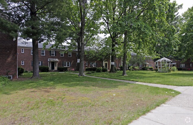
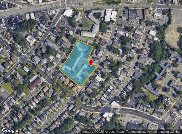
Property Record
28 Nesbit Ter, Irvington, NJ 07111

NEARBY LISTINGS FOR SALE OR LEASE
Property Detail
28 Nesbit Ter
09-00335-0000-00002
IRR.
Apartment
Essex
X
New Jersey
34013C0151F
2
2023
2.10 AC
2025
Irvington
012400
Northern New Jersey
5,328 SF
Newark, NJ-PA
DEMOGRAPHICS near 28 Nesbit Ter
1 Mile
3 Mile
5 Mile
2024 Total Population
56,478
349,315
780,946
2029 Population
54,794
340,506
761,483
Pop Growth 2024-2029
(2.98%)
(2.52%)
(2.49%)
Average Age
38
38
38
2024 Total Households
20,593
124,826
281,838
HH Growth 2024-2029
(3.20%)
(2.63%)
(2.55%)
Median Household Inc
$54,083
$57,542
$60,307
Avg Household Size
2.60
2.70
2.60
2024 Avg HH Vehicles
1.00
1.00
1.00
Median Home Value
$253,652
$359,436
$384,716
Median Year Built
1954
1956
1958
Nearby Places
Map Layers
Map Styles
 Street
 Aerial
- Restaurants
- Banks
- Shops
- Fitness
- Groceries
PUBLIC TRANSPORTATION
COMMUTER RAIL
Maplewood (Morris & Essex Gladstone Branch - NJ Transit Commuter Rail (NJ Transit), Morris & Essex Morristown Line - NJ Transit Commuter Rail (NJ Transit))
DRIVE
WALK
Distance
Maplewood (Morris & Essex Gladstone Branch - NJ Transit Commuter Rail (NJ Transit), Morris & Essex Morristown Line - NJ Transit Commuter Rail (NJ Transit))
8 min
2.9 mi
South Orange (Morris & Essex Gladstone Branch - NJ Transit Commuter Rail (NJ Transit), Morris & Essex Morristown Line - NJ Transit Commuter Rail (NJ Transit))
DRIVE
WALK
Distance
South Orange (Morris & Essex Gladstone Branch - NJ Transit Commuter Rail (NJ Transit), Morris & Essex Morristown Line - NJ Transit Commuter Rail (NJ Transit))
7 min
2.9 mi
AIRPORT
Newark Liberty International
DRIVE
WALK
Distance
Newark Liberty International
9 min
6.2 mi
LaGuardia
DRIVE
WALK
Distance
LaGuardia
43 min
25.4 mi
John F Kennedy International
DRIVE
WALK
Distance
John F Kennedy International
53 min
33.6 mi
Freight Ports
Maher Terminal
DRIVE
WALK
Distance
Maher Terminal
12 min
6.7 mi
Nearby Properties
Address
Land Use
TOTAL SIZE
Lot Size
Zoning
Address
Land Use
TOTAL SIZE
Lot Size
Zoning
57.23 AC
U
Address
Land Use
TOTAL SIZE
Lot Size
Zoning
926,120 SF
11.46 AC
Address
Land Use
TOTAL SIZE
Lot Size
Zoning
0.61 AC
Address
Land Use
TOTAL SIZE
Lot Size
Zoning
31.86 AC
Address
Land Use
TOTAL SIZE
Lot Size
Zoning
1,136 SF
6.51 AC
Address
Land Use
TOTAL SIZE
Lot Size
Zoning
32.27 AC
CCRC
Address
Land Use
TOTAL SIZE
Lot Size
Zoning
9.77 AC
Address
Land Use
TOTAL SIZE
Lot Size
Zoning
4.82 AC
Address
Land Use
TOTAL SIZE
Lot Size
Zoning
0.06 AC
Address
Land Use
TOTAL SIZE
Lot Size
Zoning
Address
Land Use
TOTAL SIZE
Lot Size
Zoning
Address
Land Use
TOTAL SIZE
Lot Size
Zoning
0.23 AC
REDV
Address
Land Use
TOTAL SIZE
Lot Size
Zoning
4.60 AC
PRD
Address
Land Use
TOTAL SIZE
Lot Size
Zoning
13.80 AC
R1-5
Address
Land Use
TOTAL SIZE
Lot Size
Zoning
Address
Land Use
TOTAL SIZE
Lot Size
Zoning
16.14 AC
Address
Land Use
TOTAL SIZE
Lot Size
Zoning
310.45 AC
Address
Land Use
TOTAL SIZE
Lot Size
Zoning
7.03 AC
Address
Land Use
TOTAL SIZE
Lot Size
Zoning
Address
Land Use
TOTAL SIZE
Lot Size
Zoning
7.07 AC
Address
Land Use
TOTAL SIZE
Lot Size
Zoning
3.28 AC
Address
Land Use
TOTAL SIZE
Lot Size
Zoning
2.06 AC
Address
Land Use
TOTAL SIZE
Lot Size
Zoning
19,498 SF
0.67 AC
FVRZ
Address
Land Use
TOTAL SIZE
Lot Size
Zoning
Address
Land Use
TOTAL SIZE
Lot Size
Zoning
295,160 SF
3.72 AC
Address
Land Use
TOTAL SIZE
Lot Size
Zoning
Address
Land Use
TOTAL SIZE
Lot Size
Zoning
6.05 AC
RO
Address
Land Use
TOTAL SIZE
Lot Size
Zoning
0.01 AC
Address
Land Use
TOTAL SIZE
Lot Size
Zoning
3.64 AC
Address
Land Use
TOTAL SIZE
Lot Size
Zoning
33.92 AC
The World's #1 Commercial Real Estate Marketplace
Connect with us
© 2025 CoStar Group
The information above has been obtained from sources believed reliable. While we do not doubt its accuracy we have not verified it and make no guarantee, warranty or representation about it. It is your responsibility to independently confirm its accuracy and completeness. Any projections, opinions, assumptions, or estimates used are for example only and do not represent the current or future performance of the property. The value of this transaction to you depends on tax and other factors which should be evaluated by your tax, financial, and legal advisors. You and your advisors should conduct a careful, independent investigation of the property to determine to your satisfaction the suitability of the property for your needs.