Property Record
28 Noah Ct, Ringgold, GA 30736
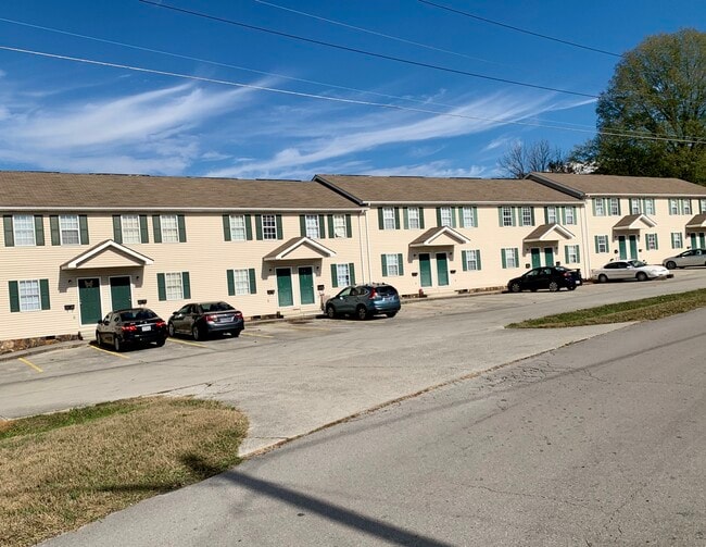

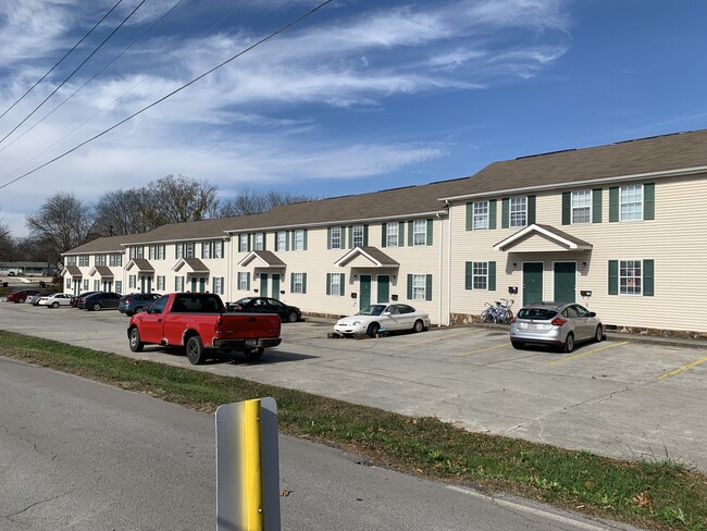
Property Detail
28 Noah Ct
R0060-130
TRACTS 1 & 2 AMLIN INC APTS -TOWN VILLA
Apartment
Catoosa
RIN R-3
Georgia
AE The base floodplain where base flood elevations are provided. AE Zones are now used on new format FIRMs instead of A1-A30 Zones.
tr 1&2
2025
1.44 AC
2025
Outlying Catoosa County
030201
Chattanooga
14,392 SF
Chattanooga, TN-GA
NEARBY LISTINGS FOR SALE OR LEASE
-
-
View all Ringgold listings for sale on LoopNet.com
DEMOGRAPHICS near 28 Noah Ct
1 mile
3 mile
5 mile
2025 Total Population
2,070
12,375
31,773
2030 Population
2,097
12,468
32,161
Pop Growth 2025-2030
+ 1.30%
+ 0.75%
+ 1.22%
Average Age
40
41
41
2025 Total Households
856
4,866
11,994
HH Growth 2025-2030
+ 1.40%
+ 0.82%
+ 1.28%
Median Household Inc
$69,545
$73,174
$82,641
Avg Household Size
2.30
2.50
2.60
2025 Avg HH Vehicles
2.00
2.00
2.00
Median Home Value
$232,490
$277,560
$273,624
Median Year Built
1998
1992
1992
Nearby Places
Map Layers
Map Styles
 Street
 Aerial
Layers
 Traffic
 Biking
Places
Listings with unknown addresses are not visible on the map
- Restaurants
- Banks
- Shops
- Fitness
- Groceries
PUBLIC TRANSPORTATION
AIRPORT
Lovell Field
Drive
Walk
Distance
Lovell Field
24 min
14.2 mi
Freight Ports
Georgia Ports - Savannah
Drive
Walk
Distance
Georgia Ports - Savannah
392 min
349.4 mi
SALE & LEASE HISTORY
LISTING DATE
SALE/LEASE

Nov 21, 2022
For Sale
Nearby Properties
Address
Land Use
TOTAL SIZE
Lot Size
Zoning
Address
Land Use
TOTAL SIZE
Lot Size
Zoning
5,611 SF
13.92 AC
RIN R-1
Address
Land Use
TOTAL SIZE
Lot Size
Zoning
309,500 SF
35.52 AC
RIN I-1
Address
Land Use
TOTAL SIZE
Lot Size
Zoning
9,672 SF
49 AC
RIN R-1
Address
Land Use
TOTAL SIZE
Lot Size
Zoning
134,672 SF
28.83 AC
R-1
Address
Land Use
TOTAL SIZE
Lot Size
Zoning
604,939 SF
39.50 AC
RIN I-1
Address
Land Use
TOTAL SIZE
Lot Size
Zoning
2,299 SF
10 AC
RIN R-1
Address
Land Use
TOTAL SIZE
Lot Size
Zoning
50,959 SF
35.79 AC
RIN I-1
Address
Land Use
TOTAL SIZE
Lot Size
Zoning
319,644 SF
12.59 AC
RIN I-1
Address
Land Use
TOTAL SIZE
Lot Size
Zoning
310,894 SF
54.03 AC
RIN I-1
Address
Land Use
TOTAL SIZE
Lot Size
Zoning
1,680 SF
24.15 AC
A-1
Address
Land Use
TOTAL SIZE
Lot Size
Zoning
5,040 SF
6.29 AC
RIN C-2
Address
Land Use
TOTAL SIZE
Lot Size
Zoning
72,123 SF
13.84 AC
RIN I-1
Address
Land Use
TOTAL SIZE
Lot Size
Zoning
10,756 SF
11.20 AC
RIN C-2
Address
Land Use
TOTAL SIZE
Lot Size
Zoning
235,368 SF
16.19 AC
RIN I-1
Address
Land Use
TOTAL SIZE
Lot Size
Zoning
223,680 SF
50.50 AC
RIN I-1
Address
Land Use
TOTAL SIZE
Lot Size
Zoning
6,696 SF
4.72 AC
RIN R-3
Address
Land Use
TOTAL SIZE
Lot Size
Zoning
88,000 SF
7.16 AC
RIN I-1
Address
Land Use
TOTAL SIZE
Lot Size
Zoning
46,288 SF
2.40 AC
RIN C-2
Address
Land Use
TOTAL SIZE
Lot Size
Zoning
32,737 SF
7.57 AC
RIN C-2
Address
Land Use
TOTAL SIZE
Lot Size
Zoning
46,360 SF
1.15 AC
RIN C-2
Address
Land Use
TOTAL SIZE
Lot Size
Zoning
193,200 SF
23.12 AC
RIN I-1
Address
Land Use
TOTAL SIZE
Lot Size
Zoning
2,959 SF
10.05 AC
SZ
Address
Land Use
TOTAL SIZE
Lot Size
Zoning
43,457 SF
7.16 AC
RIN C-2
Address
Land Use
TOTAL SIZE
Lot Size
Zoning
34,927 SF
2.50 AC
RIN C-2
Address
Land Use
TOTAL SIZE
Lot Size
Zoning
8,940 SF
12.29 AC
RIN I-1
Address
Land Use
TOTAL SIZE
Lot Size
Zoning
95,650 SF
23.80 AC
RIN I-1
Address
Land Use
TOTAL SIZE
Lot Size
Zoning
28,475 SF
1.65 AC
RIN C-2
Address
Land Use
TOTAL SIZE
Lot Size
Zoning
55,060 SF
11.91 AC
RIN C-2
Address
Land Use
TOTAL SIZE
Lot Size
Zoning
31,186 SF
8.19 AC
RIN C-2
Address
Land Use
TOTAL SIZE
Lot Size
Zoning
9,272 SF
1.33 AC
RIN C-3
The World's #1 Commercial Real Estate Marketplace
Connect with us
© 2026 CoStar Group
The information above has been obtained from sources believed reliable. While we do not doubt its accuracy we have not verified it and make no guarantee, warranty or representation about it. It is your responsibility to independently confirm its accuracy and completeness. Any projections, opinions, assumptions, or estimates used are for example only and do not represent the current or future performance of the property. The value of this transaction to you depends on tax and other factors which should be evaluated by your tax, financial, and legal advisors. You and your advisors should conduct a careful, independent investigation of the property to determine to your satisfaction the suitability of the property for your needs.