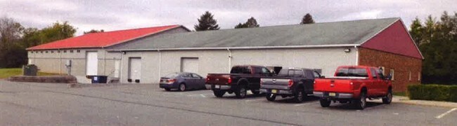
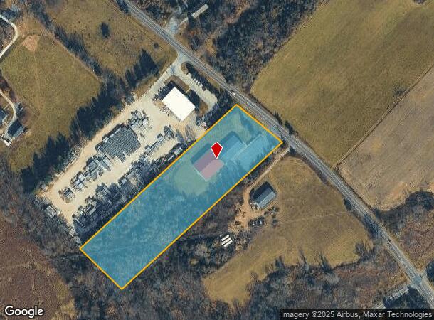
Property Record
28 Randazzo Rd, Lafayette, NJ 07848
NEARBY LISTINGS FOR SALE OR LEASE
Property Detail
28 Randazzo Rd
13-00001-01-00007-04
Sussex
Industrialgeneral
New Jersey
X
7.4
34037C0316E
5 AC
2024
Sussex County
2025
Northern New Jersey
372400
Newark, NJ-PA
15,120 SF
DEMOGRAPHICS near 28 Randazzo Rd
1 Mile
3 Mile
5 Mile
2024 Total Population
255
10,874
38,806
2029 Population
258
10,970
39,242
Pop Growth 2024-2029
+ 1.18%
+ 0.88%
+ 1.12%
Average Age
41
44
43
2024 Total Households
85
3,963
14,499
HH Growth 2024-2029
+ 1.18%
+ 0.81%
+ 1.14%
Median Household Inc
$167,857
$127,286
$114,279
Avg Household Size
2.90
2.60
2.60
2024 Avg HH Vehicles
2.00
2.00
2.00
Median Home Value
$462,499
$405,907
$366,557
Median Year Built
1986
1979
1972
Nearby Places
Map Layers
Map Styles
 Street
 Aerial
- Restaurants
- Banks
- Shops
- Fitness
- Groceries
SALE & LEASE HISTORY
LISTING DATE
SALE/LEASE

Nov 21, 2017
For Sale
Nearby Properties
Address
Land Use
TOTAL SIZE
Lot Size
Zoning
Address
Land Use
TOTAL SIZE
Lot Size
Zoning
11.86 AC
TCLC
Address
Land Use
TOTAL SIZE
Lot Size
Zoning
156,719 SF
48.98 AC
OSGU
Address
Land Use
TOTAL SIZE
Lot Size
Zoning
20.62 AC
HCMF
Address
Land Use
TOTAL SIZE
Lot Size
Zoning
28.91 AC
PVC
Address
Land Use
TOTAL SIZE
Lot Size
Zoning
10 AC
RR
Address
Land Use
TOTAL SIZE
Lot Size
Zoning
2.02 AC
PVC
Address
Land Use
TOTAL SIZE
Lot Size
Zoning
50,659 SF
9.90 AC
C-2
Address
Land Use
TOTAL SIZE
Lot Size
Zoning
45,532 SF
10.31 AC
R1
Address
Land Use
TOTAL SIZE
Lot Size
Zoning
2.27 AC
PVC
Address
Land Use
TOTAL SIZE
Lot Size
Zoning
58,607 SF
26.13 AC
RR
Address
Land Use
TOTAL SIZE
Lot Size
Zoning
76,409 SF
29.80 AC
R2
Address
Land Use
TOTAL SIZE
Lot Size
Zoning
58,605 SF
28.29 AC
OSGU
Address
Land Use
TOTAL SIZE
Lot Size
Zoning
3,280 SF
17.30 AC
MF
Address
Land Use
TOTAL SIZE
Lot Size
Zoning
11,843 SF
9.68 AC
RR
Address
Land Use
TOTAL SIZE
Lot Size
Zoning
47,786 SF
8.60 AC
TCCO
Address
Land Use
TOTAL SIZE
Lot Size
Zoning
35,884 SF
4.73 AC
C-2
Address
Land Use
TOTAL SIZE
Lot Size
Zoning
528 SF
10.85 AC
RR
Address
Land Use
TOTAL SIZE
Lot Size
Zoning
29,156 SF
121.97 AC
L-1
Address
Land Use
TOTAL SIZE
Lot Size
Zoning
5 AC
R1
Address
Land Use
TOTAL SIZE
Lot Size
Zoning
58.78 AC
PDRM
Address
Land Use
TOTAL SIZE
Lot Size
Zoning
15,400 SF
53.92 AC
PDRM
Address
Land Use
TOTAL SIZE
Lot Size
Zoning
65,064 SF
7.17 AC
L-1
Address
Land Use
TOTAL SIZE
Lot Size
Zoning
31,620 SF
8.18 AC
HCMF
Address
Land Use
TOTAL SIZE
Lot Size
Zoning
31,504 SF
3.06 AC
ED-1
Address
Land Use
TOTAL SIZE
Lot Size
Zoning
23,184 SF
82.13 AC
OSGU
Address
Land Use
TOTAL SIZE
Lot Size
Zoning
29.26 AC
HCR3
Address
Land Use
TOTAL SIZE
Lot Size
Zoning
10 AC
RR
Address
Land Use
TOTAL SIZE
Lot Size
Zoning
35,301 SF
3.74 AC
TCC
Address
Land Use
TOTAL SIZE
Lot Size
Zoning
5.59 AC
TCLC
Address
Land Use
TOTAL SIZE
Lot Size
Zoning
42,036 SF
2.94 AC
C-1
The World's #1 Commercial Real Estate Marketplace
Connect with us
© 2025 CoStar Group
The information above has been obtained from sources believed reliable. While we do not doubt its accuracy we have not verified it and make no guarantee, warranty or representation about it. It is your responsibility to independently confirm its accuracy and completeness. Any projections, opinions, assumptions, or estimates used are for example only and do not represent the current or future performance of the property. The value of this transaction to you depends on tax and other factors which should be evaluated by your tax, financial, and legal advisors. You and your advisors should conduct a careful, independent investigation of the property to determine to your satisfaction the suitability of the property for your needs.