Property Record
28 Wilbur Cross Way, Storrs Mansfield, CT 06268

NEARBY LISTINGS FOR SALE OR LEASE
-
-
View all Storrs Mansfield listings for sale on LoopNet.com
Property Detail
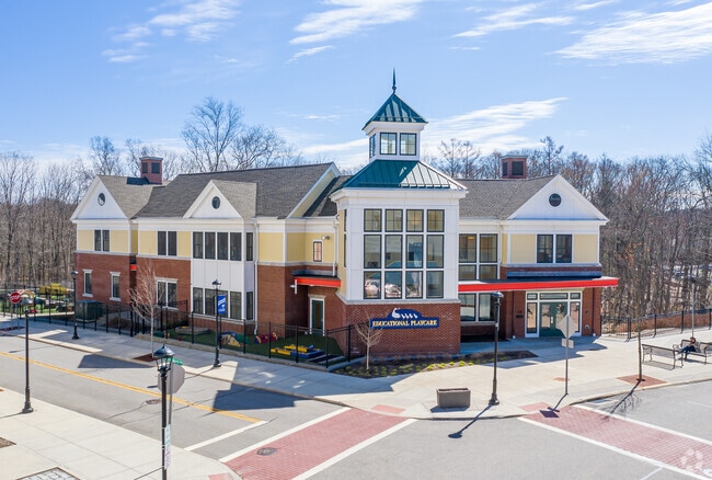
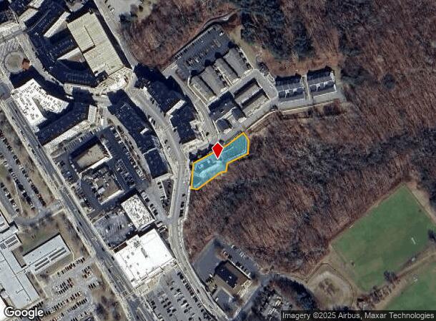
28 Wilbur Cross Way
Hartford-West Hartford-East Hartford, CT
Tolland
MANS-000016-000041-000013-000002B
Connecticut
Commercialbuilding
13-2b
2025
0.51 AC
2025
Tolland County
881100
Hartford
13,440 SF
DEMOGRAPHICS near 28 Wilbur Cross Way
1 Mile
3 Mile
5 Mile
2024 Total Population
13,296
22,232
36,296
2029 Population
13,137
22,174
36,266
Pop Growth 2024-2029
(1.20%)
(0.26%)
(0.08%)
Average Age
24
29
34
2024 Total Households
1,130
4,026
9,947
HH Growth 2024-2029
(3.01%)
(0.37%)
(0.05%)
Median Household Inc
$21,443
$30,496
$52,012
Avg Household Size
2.10
2.20
2.30
2024 Avg HH Vehicles
1.00
2.00
2.00
Median Home Value
$321,354
$291,605
$277,508
Median Year Built
2003
1978
1974
Nearby Places
Map Layers
Map Styles
 Street
 Aerial
- Restaurants
- Banks
- Shops
- Fitness
- Groceries
PUBLIC TRANSPORTATION
AIRPORT
Bradley International
DRIVE
WALK
Distance
Bradley International
60 min
35.3 mi
Freight Ports
Port of Davisville, RI
DRIVE
WALK
Distance
Port of Davisville, RI
91 min
64.3 mi
Nearby Properties
Address
Land Use
TOTAL SIZE
Lot Size
Zoning
Address
Land Use
TOTAL SIZE
Lot Size
Zoning
253,885 SF
I
Address
Land Use
TOTAL SIZE
Lot Size
Zoning
121,528 SF
Address
Land Use
TOTAL SIZE
Lot Size
Zoning
257,360 SF
1 AC
I
Address
Land Use
TOTAL SIZE
Lot Size
Zoning
171,605 SF
5.30 AC
PB4
Address
Land Use
TOTAL SIZE
Lot Size
Zoning
120,135 SF
Address
Land Use
TOTAL SIZE
Lot Size
Zoning
153,234 SF
1 AC
I
Address
Land Use
TOTAL SIZE
Lot Size
Zoning
213,280 SF
1 AC
I
Address
Land Use
TOTAL SIZE
Lot Size
Zoning
203,904 SF
1 AC
I
Address
Land Use
TOTAL SIZE
Lot Size
Zoning
111,455 SF
1 AC
I
Address
Land Use
TOTAL SIZE
Lot Size
Zoning
255,750 SF
1 AC
I
Address
Land Use
TOTAL SIZE
Lot Size
Zoning
227,479 SF
2 AC
I
Address
Land Use
TOTAL SIZE
Lot Size
Zoning
35,212 SF
3.20 AC
I
Address
Land Use
TOTAL SIZE
Lot Size
Zoning
Address
Land Use
TOTAL SIZE
Lot Size
Zoning
155,276 SF
1.37 AC
SCDD
Address
Land Use
TOTAL SIZE
Lot Size
Zoning
Address
Land Use
TOTAL SIZE
Lot Size
Zoning
83,869 SF
I
Address
Land Use
TOTAL SIZE
Lot Size
Zoning
Address
Land Use
TOTAL SIZE
Lot Size
Zoning
Address
Land Use
TOTAL SIZE
Lot Size
Zoning
23.33 AC
PB3
Address
Land Use
TOTAL SIZE
Lot Size
Zoning
66,136 SF
1 AC
I
Address
Land Use
TOTAL SIZE
Lot Size
Zoning
115,104 SF
1 AC
I
Address
Land Use
TOTAL SIZE
Lot Size
Zoning
21.54 AC
I
Address
Land Use
TOTAL SIZE
Lot Size
Zoning
77,333 SF
1 AC
I
Address
Land Use
TOTAL SIZE
Lot Size
Zoning
88,000 SF
1 AC
Address
Land Use
TOTAL SIZE
Lot Size
Zoning
83,297 SF
SCDD
Address
Land Use
TOTAL SIZE
Lot Size
Zoning
75,328 SF
1 AC
I
Address
Land Use
TOTAL SIZE
Lot Size
Zoning
9.48 AC
DMR
Address
Land Use
TOTAL SIZE
Lot Size
Zoning
71,221 SF
1.72 AC
SCDD
Address
Land Use
TOTAL SIZE
Lot Size
Zoning
70,696 SF
1 AC
I
Address
Land Use
TOTAL SIZE
Lot Size
Zoning
24,067 SF
1 AC
I
The World's #1 Commercial Real Estate Marketplace
Connect with us
© 2025 CoStar Group
The information above has been obtained from sources believed reliable. While we do not doubt its accuracy we have not verified it and make no guarantee, warranty or representation about it. It is your responsibility to independently confirm its accuracy and completeness. Any projections, opinions, assumptions, or estimates used are for example only and do not represent the current or future performance of the property. The value of this transaction to you depends on tax and other factors which should be evaluated by your tax, financial, and legal advisors. You and your advisors should conduct a careful, independent investigation of the property to determine to your satisfaction the suitability of the property for your needs.