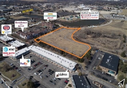
Property Record
280 Knollwood Dr, Bloomingdale, IL 60108


NEARBY LISTINGS FOR SALE OR LEASE
Property Detail
280 Knollwood Dr
Chicago-Naperville-Elgin, IL-IN
Stratford Assmt Plat No 3
02-20-206-037
STRATFORD ASSMT PLAT NO 3 LTS 7 & 8 LYG S & W OF STRATFORD COMMONS ASSMT PLAT E OF THARALDSONS ASSMT PLAT/EX STRATFORD DEV PARCEL 3 SOUTH SUB& ASSMT PLAT OF LT 2/& /EX S 7.02FT/
Commercialnec
DuPage
X
Illinois
17043C0053J
7,8
2024
5.28 AC
2024
North DuPage
841113
Chicago
138,515 SF
DEMOGRAPHICS near 280 Knollwood Dr
1 Mile
3 Mile
5 Mile
2024 Total Population
5,322
105,761
240,092
2029 Population
5,325
103,725
234,192
Pop Growth 2024-2029
+ 0.06%
(1.93%)
(2.46%)
Average Age
42
41
40
2024 Total Households
2,107
37,113
84,259
HH Growth 2024-2029
(0.19%)
(2.00%)
(2.60%)
Median Household Inc
$104,864
$95,517
$95,952
Avg Household Size
2.50
2.70
2.70
2024 Avg HH Vehicles
2.00
2.00
2.00
Median Home Value
$374,694
$280,820
$294,455
Median Year Built
1989
1980
1978
Nearby Places
Map Layers
Map Styles
 Street
 Aerial
- Restaurants
- Banks
- Shops
- Fitness
- Groceries
PUBLIC TRANSPORTATION
COMMUTER RAIL
Schaumburg Station (Milwaukee District West Line - Northeast Illinois Regional Commuter Railroad (Metra))
DRIVE
WALK
Distance
Schaumburg Station (Milwaukee District West Line - Northeast Illinois Regional Commuter Railroad (Metra))
12 min
5.6 mi
Roselle Station (Milwaukee District West Line - Northeast Illinois Regional Commuter Railroad (Metra))
DRIVE
WALK
Distance
Roselle Station (Milwaukee District West Line - Northeast Illinois Regional Commuter Railroad (Metra))
14 min
6.5 mi
AIRPORT
Chicago O'Hare International
DRIVE
WALK
Distance
Chicago O'Hare International
32 min
18.8 mi
Chicago Midway International
DRIVE
WALK
Distance
Chicago Midway International
42 min
28.5 mi
Freight Ports
Port Milwaukee
DRIVE
WALK
Distance
Port Milwaukee
112 min
91.3 mi
SALE & LEASE HISTORY
LISTING DATE
SALE/LEASE

Sep 24, 2016
For Sale
Apr 04, 2019
For Sale
Nearby Properties
Address
Land Use
TOTAL SIZE
Lot Size
Zoning
Address
Land Use
TOTAL SIZE
Lot Size
Zoning
693,153 SF
46.17 AC
Address
Land Use
TOTAL SIZE
Lot Size
Zoning
345,600 SF
23.40 AC
M
Address
Land Use
TOTAL SIZE
Lot Size
Zoning
260,424 SF
16.87 AC
M
Address
Land Use
TOTAL SIZE
Lot Size
Zoning
322,680 SF
19.07 AC
M
Address
Land Use
TOTAL SIZE
Lot Size
Zoning
268,400 SF
15.87 AC
M
Address
Land Use
TOTAL SIZE
Lot Size
Zoning
236,871 SF
12.84 AC
M
Address
Land Use
TOTAL SIZE
Lot Size
Zoning
251,091 SF
32.67 AC
R-4
Address
Land Use
TOTAL SIZE
Lot Size
Zoning
9.34 AC
M
Address
Land Use
TOTAL SIZE
Lot Size
Zoning
16.91 AC
C
Address
Land Use
TOTAL SIZE
Lot Size
Zoning
515,497 SF
21.98 AC
I
Address
Land Use
TOTAL SIZE
Lot Size
Zoning
527,079 SF
29.01 AC
I
Address
Land Use
TOTAL SIZE
Lot Size
Zoning
226,069 SF
14.85 AC
Address
Land Use
TOTAL SIZE
Lot Size
Zoning
367,020 SF
26.13 AC
I
Address
Land Use
TOTAL SIZE
Lot Size
Zoning
582,089 SF
41.71 AC
C
Address
Land Use
TOTAL SIZE
Lot Size
Zoning
381,600 SF
24.47 AC
Address
Land Use
TOTAL SIZE
Lot Size
Zoning
304,976 SF
23.98 AC
Address
Land Use
TOTAL SIZE
Lot Size
Zoning
400,032 SF
21.12 AC
I
Address
Land Use
TOTAL SIZE
Lot Size
Zoning
436,765 SF
7 AC
M
Address
Land Use
TOTAL SIZE
Lot Size
Zoning
311,052 SF
20.97 AC
M
Address
Land Use
TOTAL SIZE
Lot Size
Zoning
393,516 SF
18.08 AC
I
Address
Land Use
TOTAL SIZE
Lot Size
Zoning
347,400 SF
15.31 AC
I
Address
Land Use
TOTAL SIZE
Lot Size
Zoning
306,870 SF
31.76 AC
I
Address
Land Use
TOTAL SIZE
Lot Size
Zoning
352,089 SF
21.13 AC
I
Address
Land Use
TOTAL SIZE
Lot Size
Zoning
6.20 AC
M
Address
Land Use
TOTAL SIZE
Lot Size
Zoning
302,986 SF
16.04 AC
Address
Land Use
TOTAL SIZE
Lot Size
Zoning
166,382 SF
10.50 AC
R-4
Address
Land Use
TOTAL SIZE
Lot Size
Zoning
275,091 SF
13.38 AC
I
Address
Land Use
TOTAL SIZE
Lot Size
Zoning
334,718 SF
15.95 AC
I
Address
Land Use
TOTAL SIZE
Lot Size
Zoning
327,858 SF
15.10 AC
I
Address
Land Use
TOTAL SIZE
Lot Size
Zoning
360,676 SF
18.86 AC
The World's #1 Commercial Real Estate Marketplace
Connect with us
© 2026 CoStar Group
The information above has been obtained from sources believed reliable. While we do not doubt its accuracy we have not verified it and make no guarantee, warranty or representation about it. It is your responsibility to independently confirm its accuracy and completeness. Any projections, opinions, assumptions, or estimates used are for example only and do not represent the current or future performance of the property. The value of this transaction to you depends on tax and other factors which should be evaluated by your tax, financial, and legal advisors. You and your advisors should conduct a careful, independent investigation of the property to determine to your satisfaction the suitability of the property for your needs.