Property Record
280 Main St, Colorado Springs, CO 80911
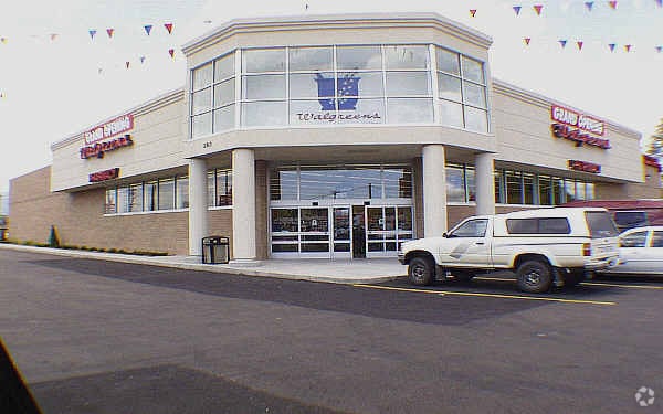

This Property Is For Sale
Property Detail
280 Main St
65114-07-101
PART OF LOT 15 BLK 13 SECURITY, COLO, ADD 6 AS FOLS, BEG AT INTSEC OF WLY LN OF SECURITY BLVD + NLY LN MAIN ST, TH NWLY ON WLY LN OF SECURITY BLVD 200 FT, TH SWLY PARA TO NWLY LN OF MAIN ST 200 FT, SELY PARA TO WLY LN OF SECURITY BLVD 200 FT TO PT ON
Commercialbuilding
EL PASO
CC
Colorado
AE The base floodplain where base flood elevations are provided. AE Zones are now used on new format FIRMs instead of A1-A30 Zones.
15
2024
0.92 AC
2025
Southeast
004100
Colorado Springs
13,833 SF
Colorado Springs, CO
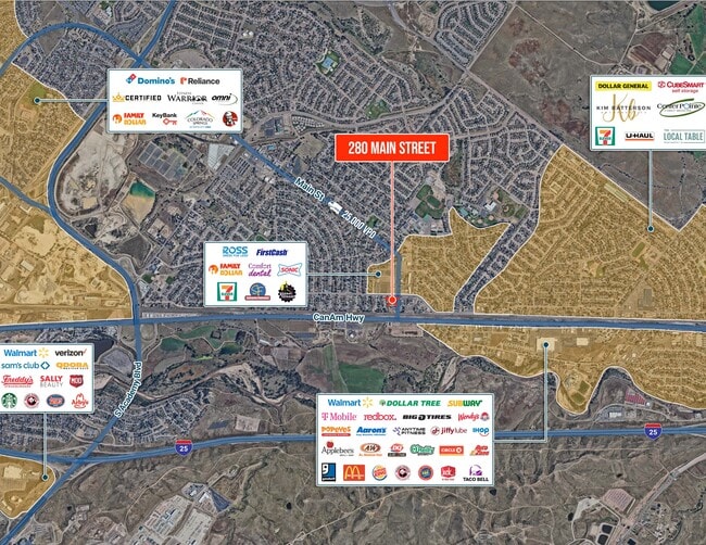
NEARBY LISTINGS FOR SALE OR LEASE
DEMOGRAPHICS near 280 Main St
1 mile
3 mile
5 mile
2024 Total Population
9,503
54,987
157,066
2029 Population
9,525
55,425
159,592
Pop Growth 2024-2029
+ 0.23%
+ 0.80%
+ 1.61%
Average Age
38
35
34
2024 Total Households
3,542
16,709
53,167
HH Growth 2024-2029
+ 0.48%
+ 1.01%
+ 1.88%
Median Household Inc
$73,771
$75,547
$75,132
Avg Household Size
2.60
2.80
2.70
2024 Avg HH Vehicles
2.00
2.00
2.00
Median Home Value
$341,972
$358,804
$381,096
Median Year Built
1964
1983
1988
Nearby Places
Map Layers
Map Styles
 Street
 Aerial
Transit
 Traffic
 Biking
Places
Listings with unknown addresses are not visible on the map
- Restaurants
- Banks
- Shops
- Fitness
- Groceries
PUBLIC TRANSPORTATION
AIRPORT
City of Colorado Springs Municipal
Drive
Walk
Distance
City of Colorado Springs Municipal
19 min
9.0 mi
Nearby Properties
Address
Land Use
TOTAL SIZE
Lot Size
Zoning
Address
Land Use
TOTAL SIZE
Lot Size
Zoning
241,806 SF
937.06 AC
A-5 CAD-O
Address
Land Use
TOTAL SIZE
Lot Size
Zoning
3,486,127 SF
69.25 AC
APD APZ1 A
Address
Land Use
TOTAL SIZE
Lot Size
Zoning
48,255 SF
17.35 AC
A-5 CAD-O
Address
Land Use
TOTAL SIZE
Lot Size
Zoning
278,331 SF
324.19 AC
Address
Land Use
TOTAL SIZE
Lot Size
Zoning
34,984 SF
14.31 AC
A-5
Address
Land Use
TOTAL SIZE
Lot Size
Zoning
92.06 AC
APD APZ1 A
Address
Land Use
TOTAL SIZE
Lot Size
Zoning
130,569 SF
3.23 AC
Address
Land Use
TOTAL SIZE
Lot Size
Zoning
22,596 SF
3.93 AC
R-5 UV AO
Address
Land Use
TOTAL SIZE
Lot Size
Zoning
50,992 SF
10.27 AC
PDZ AO
Address
Land Use
TOTAL SIZE
Lot Size
Zoning
131,040 SF
8.50 AC
BP/CR AO
Address
Land Use
TOTAL SIZE
Lot Size
Zoning
92,000 SF
9.56 AC
MX-M UV AO
Address
Land Use
TOTAL SIZE
Lot Size
Zoning
66,640 SF
6.87 AC
MX-M CU AO
Address
Land Use
TOTAL SIZE
Lot Size
Zoning
322,147 SF
35.10 AC
I-2 CAD-O
Address
Land Use
TOTAL SIZE
Lot Size
Zoning
43,914 SF
9.36 AC
A-5 CAD-O
Address
Land Use
TOTAL SIZE
Lot Size
Zoning
207,858 SF
18.08 AC
C-2 R-2
Address
Land Use
TOTAL SIZE
Lot Size
Zoning
168.20 AC
APD APZ1 A
Address
Land Use
TOTAL SIZE
Lot Size
Zoning
2.09 AC
MX-M CU AO
Address
Land Use
TOTAL SIZE
Lot Size
Zoning
19,308 SF
2.69 AC
RM-30 CAD-
Address
Land Use
TOTAL SIZE
Lot Size
Zoning
9,448 SF
212.16 AC
A-5
Address
Land Use
TOTAL SIZE
Lot Size
Zoning
131,040 SF
9.68 AC
BP AO
Address
Land Use
TOTAL SIZE
Lot Size
Zoning
163,073 SF
14.57 AC
PUD
Address
Land Use
TOTAL SIZE
Lot Size
Zoning
278,331 SF
6.39 AC
Address
Land Use
TOTAL SIZE
Lot Size
Zoning
99,960 SF
8.21 AC
BP AO
Address
Land Use
TOTAL SIZE
Lot Size
Zoning
8,252 SF
44.09 AC
A-5
Address
Land Use
TOTAL SIZE
Lot Size
Zoning
19,813 SF
16.55 AC
A-5 CAD-O
Address
Land Use
TOTAL SIZE
Lot Size
Zoning
57,430 SF
9.19 AC
R-1 6 DF A
Address
Land Use
TOTAL SIZE
Lot Size
Zoning
Address
Land Use
TOTAL SIZE
Lot Size
Zoning
66,780 SF
18.74 AC
APD APZ2 A
Address
Land Use
TOTAL SIZE
Lot Size
Zoning
278,331 SF
108.87 AC
APD AO APZ
Address
Land Use
TOTAL SIZE
Lot Size
Zoning
139,043 SF
13.97 AC
PUD
The World's #1 Commercial Real Estate Marketplace
Connect with us
© 2026 CoStar Group
The information above has been obtained from sources believed reliable. While we do not doubt its accuracy we have not verified it and make no guarantee, warranty or representation about it. It is your responsibility to independently confirm its accuracy and completeness. Any projections, opinions, assumptions, or estimates used are for example only and do not represent the current or future performance of the property. The value of this transaction to you depends on tax and other factors which should be evaluated by your tax, financial, and legal advisors. You and your advisors should conduct a careful, independent investigation of the property to determine to your satisfaction the suitability of the property for your needs.