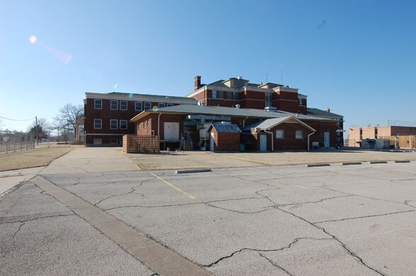
Property Record
280 N Virginia Ave, Bartlesville, OK 74003


NEARBY LISTINGS FOR SALE OR LEASE
Property Detail
280 N Virginia Ave
Bartlesville, OK
Geo B Keeler 4Th
0025502
N 155' OF BLK 2 GEO B KEELER 4TH
Manufacturinglight
Washington
X
Oklahoma
40147C0115D
1
2024
1.01 AC
2025
Bartlesville
000200
Tulsa
5,920 SF
DEMOGRAPHICS near 280 N Virginia Ave
1 Mile
3 Mile
5 Mile
2024 Total Population
3,120
16,916
43,839
2029 Population
3,371
17,948
46,072
Pop Growth 2024-2029
+ 8.04%
+ 6.10%
+ 5.09%
Average Age
40
39
41
2024 Total Households
1,276
6,924
17,809
HH Growth 2024-2029
+ 8.39%
+ 6.17%
+ 5.05%
Median Household Inc
$31,144
$39,669
$52,997
Avg Household Size
2.20
2.30
2.30
2024 Avg HH Vehicles
1.00
2.00
2.00
Median Home Value
$60,992
$86,489
$145,898
Median Year Built
1951
1956
1968
Nearby Places
Map Layers
Map Styles
 Street
 Aerial
- Restaurants
- Banks
- Shops
- Fitness
- Groceries
SALE & LEASE HISTORY
LISTING DATE
SALE/LEASE

Sep 25, 2016
For Lease
Mar 01, 2018
For Sale
Nearby Properties
Address
Land Use
TOTAL SIZE
Lot Size
Zoning
Address
Land Use
TOTAL SIZE
Lot Size
Zoning
28,384 SF
0.48 AC
AA1
Address
Land Use
TOTAL SIZE
Lot Size
Zoning
390,750 SF
1.55 AC
AA1
Address
Land Use
TOTAL SIZE
Lot Size
Zoning
13,977 SF
1.38 AC
AA1
Address
Land Use
TOTAL SIZE
Lot Size
Zoning
60,500 SF
6.72 AC
AA1
Address
Land Use
TOTAL SIZE
Lot Size
Zoning
21,230 SF
2.69 AC
AA1
Address
Land Use
TOTAL SIZE
Lot Size
Zoning
116,550 SF
0.32 AC
AA1
Address
Land Use
TOTAL SIZE
Lot Size
Zoning
336,066 SF
2.41 AC
AA1
Address
Land Use
TOTAL SIZE
Lot Size
Zoning
4,962 SF
0.48 AC
AA1
Address
Land Use
TOTAL SIZE
Lot Size
Zoning
2,409 SF
2.07 AC
AA1
Address
Land Use
TOTAL SIZE
Lot Size
Zoning
90,510 SF
9.41 AC
Address
Land Use
TOTAL SIZE
Lot Size
Zoning
243,155 SF
0.61 AC
AA1
Address
Land Use
TOTAL SIZE
Lot Size
Zoning
56,750 SF
0.32 AC
AA1
Address
Land Use
TOTAL SIZE
Lot Size
Zoning
156,600 SF
2.41 AC
AA1
Address
Land Use
TOTAL SIZE
Lot Size
Zoning
5,000 SF
2.32 AC
AA1
Address
Land Use
TOTAL SIZE
Lot Size
Zoning
40,704 SF
2.49 AC
AA1
Address
Land Use
TOTAL SIZE
Lot Size
Zoning
6,520 SF
1.85 AC
AA1
Address
Land Use
TOTAL SIZE
Lot Size
Zoning
12,000 SF
0.16 AC
AA1
Address
Land Use
TOTAL SIZE
Lot Size
Zoning
101,122 SF
1.10 AC
AA1
Address
Land Use
TOTAL SIZE
Lot Size
Zoning
81,500 SF
1.55 AC
AA1
Address
Land Use
TOTAL SIZE
Lot Size
Zoning
12,546 SF
0.35 AC
AA1
Address
Land Use
TOTAL SIZE
Lot Size
Zoning
92,512 SF
8.25 AC
AA1
Address
Land Use
TOTAL SIZE
Lot Size
Zoning
116,261 SF
13.97 AC
AA1
Address
Land Use
TOTAL SIZE
Lot Size
Zoning
6,150 SF
0.96 AC
AA1
Address
Land Use
TOTAL SIZE
Lot Size
Zoning
37,044 SF
0.16 AC
AA1
Address
Land Use
TOTAL SIZE
Lot Size
Zoning
179,323 SF
2.07 AC
AA1
Address
Land Use
TOTAL SIZE
Lot Size
Zoning
24,712 SF
18.08 AC
AA1
Address
Land Use
TOTAL SIZE
Lot Size
Zoning
39,158 SF
1.03 AC
AA1
Address
Land Use
TOTAL SIZE
Lot Size
Zoning
7,500 SF
0.31 AC
AA1
Address
Land Use
TOTAL SIZE
Lot Size
Zoning
15,300 SF
0.19 AC
AA1
The World's #1 Commercial Real Estate Marketplace
Connect with us
© 2025 CoStar Group
The information above has been obtained from sources believed reliable. While we do not doubt its accuracy we have not verified it and make no guarantee, warranty or representation about it. It is your responsibility to independently confirm its accuracy and completeness. Any projections, opinions, assumptions, or estimates used are for example only and do not represent the current or future performance of the property. The value of this transaction to you depends on tax and other factors which should be evaluated by your tax, financial, and legal advisors. You and your advisors should conduct a careful, independent investigation of the property to determine to your satisfaction the suitability of the property for your needs.