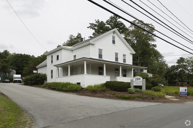
Property Record
280 Pleasant St, Concord, NH 03301
NEARBY LISTINGS FOR SALE OR LEASE
Property Detail
280 Pleasant St
CNCD-000096-000001-000015
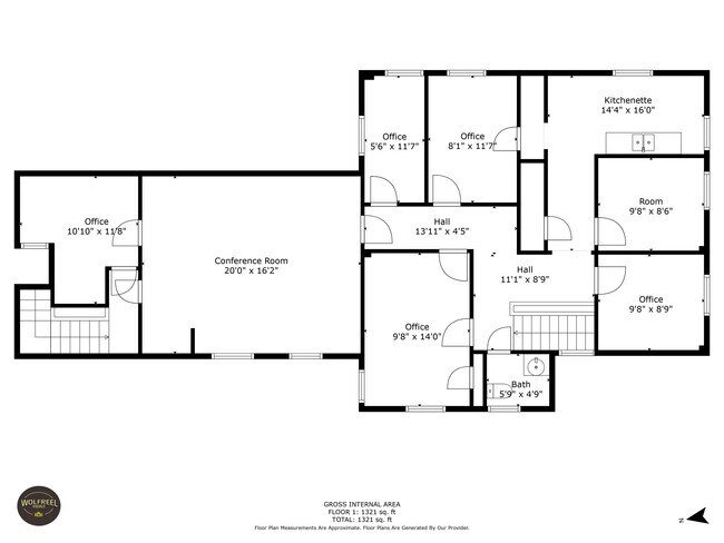
280 Condo
Officecondo
Merrimack
X
New Hampshire
33013C0530E
f-1
2024
0.92 AC
2024
Concord/New Hampshire North Area
032500
Other Market Areas
1,350 SF
Concord, NH
DEMOGRAPHICS near 280 Pleasant St
1 Mile
3 Mile
5 Mile
2024 Total Population
2,082
21,270
46,913
2029 Population
2,167
22,326
49,292
Pop Growth 2024-2029
+ 4.08%
+ 4.96%
+ 5.07%
Average Age
45
43
43
2024 Total Households
765
9,078
19,268
HH Growth 2024-2029
+ 4.18%
+ 5.19%
+ 5.15%
Median Household Inc
$127,469
$71,272
$79,938
Avg Household Size
2.40
2.10
2.20
2024 Avg HH Vehicles
2.00
2.00
2.00
Median Home Value
$491,538
$308,920
$312,970
Median Year Built
1957
1948
1974
Nearby Places
Map Layers
Map Styles
 Street
 Aerial
- Restaurants
- Banks
- Shops
- Fitness
- Groceries
PUBLIC TRANSPORTATION
AIRPORT
Manchester Boston Regional
DRIVE
WALK
Distance
Manchester Boston Regional
40 min
24.9 mi
Freight Ports
Port of Boston
DRIVE
WALK
Distance
Port of Boston
106 min
73.5 mi
SALE & LEASE HISTORY
LISTING DATE
SALE/LEASE

Sep 24, 2016
For Sale
Jan 26, 2022
For Sale
Jan 19, 2017
For Sale
Dec 12, 2018
For Lease
Aug 30, 2017
For Sale
Aug 15, 2023
For Lease
Nearby Properties
Address
Land Use
TOTAL SIZE
Lot Size
Zoning
Address
Land Use
TOTAL SIZE
Lot Size
Zoning
392 AC
IS
Address
Land Use
TOTAL SIZE
Lot Size
Zoning
196 AC
IS
Address
Land Use
TOTAL SIZE
Lot Size
Zoning
181,592 SF
5.53 AC
IS
Address
Land Use
TOTAL SIZE
Lot Size
Zoning
7.22 AC
IS
Address
Land Use
TOTAL SIZE
Lot Size
Zoning
230,929 SF
127 AC
IS
Address
Land Use
TOTAL SIZE
Lot Size
Zoning
293,984 SF
IS
Address
Land Use
TOTAL SIZE
Lot Size
Zoning
156 AC
IS
Address
Land Use
TOTAL SIZE
Lot Size
Zoning
45.40 AC
RO
Address
Land Use
TOTAL SIZE
Lot Size
Zoning
128.74 AC
IS
Address
Land Use
TOTAL SIZE
Lot Size
Zoning
15.59 AC
GWP
Address
Land Use
TOTAL SIZE
Lot Size
Zoning
10.48 AC
IS
Address
Land Use
TOTAL SIZE
Lot Size
Zoning
1.92 AC
IS
Address
Land Use
TOTAL SIZE
Lot Size
Zoning
79,703 SF
2.16 AC
CVP
Address
Land Use
TOTAL SIZE
Lot Size
Zoning
88,452 SF
1.12 AC
IS
Address
Land Use
TOTAL SIZE
Lot Size
Zoning
110 AC
IN
Address
Land Use
TOTAL SIZE
Lot Size
Zoning
75,917 SF
0.30 AC
CBP
Address
Land Use
TOTAL SIZE
Lot Size
Zoning
15.22 AC
OCP
Address
Land Use
TOTAL SIZE
Lot Size
Zoning
1.34 AC
CVP
Address
Land Use
TOTAL SIZE
Lot Size
Zoning
89,791 SF
4.56 AC
IS
Address
Land Use
TOTAL SIZE
Lot Size
Zoning
146,511 SF
19.85 AC
RS
Address
Land Use
TOTAL SIZE
Lot Size
Zoning
41.95 AC
IN
Address
Land Use
TOTAL SIZE
Lot Size
Zoning
13 AC
IS
Address
Land Use
TOTAL SIZE
Lot Size
Zoning
136,536 SF
17.69 AC
GWP
Address
Land Use
TOTAL SIZE
Lot Size
Zoning
109,643 SF
128.35 AC
IS
Address
Land Use
TOTAL SIZE
Lot Size
Zoning
52,750 SF
3.26 AC
OCP
Address
Land Use
TOTAL SIZE
Lot Size
Zoning
76,966 SF
11.15 AC
RS
Address
Land Use
TOTAL SIZE
Lot Size
Zoning
132,828 SF
1.31 AC
CBP
Address
Land Use
TOTAL SIZE
Lot Size
Zoning
106,400 SF
34.33 AC
IS
Address
Land Use
TOTAL SIZE
Lot Size
Zoning
64,843 SF
6.60 AC
C
Address
Land Use
TOTAL SIZE
Lot Size
Zoning
73,281 SF
2.80 AC
RD
The World's #1 Commercial Real Estate Marketplace
Connect with us
© 2026 CoStar Group
The information above has been obtained from sources believed reliable. While we do not doubt its accuracy we have not verified it and make no guarantee, warranty or representation about it. It is your responsibility to independently confirm its accuracy and completeness. Any projections, opinions, assumptions, or estimates used are for example only and do not represent the current or future performance of the property. The value of this transaction to you depends on tax and other factors which should be evaluated by your tax, financial, and legal advisors. You and your advisors should conduct a careful, independent investigation of the property to determine to your satisfaction the suitability of the property for your needs.