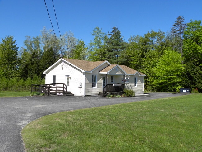
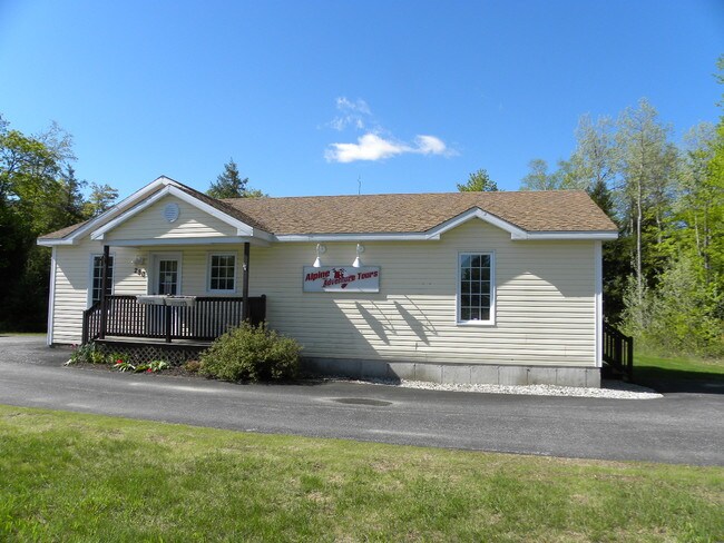
Property Record
280 Poland Spring Rd, Auburn, ME 04210

Save to a Folder
{{folder.Name}}
{{folder.ListingIds.length}} Properties
{{folder.ListingIds.length}} Property
Create a New Folder
Property Detail
280 Poland Spring Rd
AUBN-000079-000000-000010
Androscoggin
Officebuilding
Maine
B and X Area of moderate flood hazard, usually the area between the limits of the 100-year and 500-year floods.
10
2025
1.13 AC
2025
Portland Surrounding
010700
Other Market Areas
2,754 SF
Lewiston-Auburn, ME
NEARBY LISTINGS FOR SALE OR LEASE
DEMOGRAPHICS near 280 Poland Spring Rd
1 mile
3 mile
5 mile
2025 Total Population
305
4,227
15,415
2030 Population
310
4,306
15,694
Pop Growth 2025-2030
+ 1.64%
+ 1.87%
+ 1.81%
Average Age
43
43
44
2025 Total Households
121
1,705
6,138
HH Growth 2025-2030
+ 2.48%
+ 2.35%
+ 2.07%
Median Household Inc
$104,167
$97,636
$83,322
Avg Household Size
2.50
2.50
2.40
2025 Avg HH Vehicles
2.00
2.00
2.00
Median Home Value
$348,837
$329,151
$310,724
Median Year Built
1977
1985
1975
Nearby Places
Map Layers
Map Styles
 Street
 Aerial
Layers
 Traffic
 Biking
Places
Listings with unknown addresses are not visible on the map
- Restaurants
- Banks
- Shops
- Fitness
- Groceries
PUBLIC TRANSPORTATION
AIRPORT
Portland International Jetport
Drive
Walk
Distance
Portland International Jetport
42 min
32.5 mi
Freight Ports
Portland, ME
Drive
Walk
Distance
Portland, ME
44 min
32.3 mi
Nearby Properties
Address
Land Use
TOTAL SIZE
Lot Size
Zoning
Address
Land Use
TOTAL SIZE
Lot Size
Zoning
601,694 SF
62.88 AC
Address
Land Use
TOTAL SIZE
Lot Size
Zoning
300,870 SF
18.55 AC
Address
Land Use
TOTAL SIZE
Lot Size
Zoning
278,946 SF
16.83 AC
Address
Land Use
TOTAL SIZE
Lot Size
Zoning
142,868 SF
39.52 AC
Address
Land Use
TOTAL SIZE
Lot Size
Zoning
37,835 SF
345.24 AC
Address
Land Use
TOTAL SIZE
Lot Size
Zoning
163,052 SF
32.10 AC
Address
Land Use
TOTAL SIZE
Lot Size
Zoning
68,094 SF
8.94 AC
Address
Land Use
TOTAL SIZE
Lot Size
Zoning
3.77 AC
Address
Land Use
TOTAL SIZE
Lot Size
Zoning
50,400 SF
7.54 AC
Address
Land Use
TOTAL SIZE
Lot Size
Zoning
60,000 SF
Address
Land Use
TOTAL SIZE
Lot Size
Zoning
80,500 SF
7.66 AC
Address
Land Use
TOTAL SIZE
Lot Size
Zoning
103,250 SF
Address
Land Use
TOTAL SIZE
Lot Size
Zoning
31,582 SF
11.59 AC
Address
Land Use
TOTAL SIZE
Lot Size
Zoning
5,389 SF
100 AC
SHOREL
Address
Land Use
TOTAL SIZE
Lot Size
Zoning
54,800 SF
9.38 AC
Address
Land Use
TOTAL SIZE
Lot Size
Zoning
120,339 SF
72.67 AC
Address
Land Use
TOTAL SIZE
Lot Size
Zoning
61,090 SF
10.19 AC
Address
Land Use
TOTAL SIZE
Lot Size
Zoning
104,472 SF
101.68 AC
Address
Land Use
TOTAL SIZE
Lot Size
Zoning
4,599 SF
85.81 AC
COMMER
Address
Land Use
TOTAL SIZE
Lot Size
Zoning
30,296 SF
10.52 AC
Address
Land Use
TOTAL SIZE
Lot Size
Zoning
71,599 SF
6.39 AC
Address
Land Use
TOTAL SIZE
Lot Size
Zoning
50,715 SF
3.55 AC
Address
Land Use
TOTAL SIZE
Lot Size
Zoning
25,201 SF
3.40 AC
Address
Land Use
TOTAL SIZE
Lot Size
Zoning
57,090 SF
10 AC
Address
Land Use
TOTAL SIZE
Lot Size
Zoning
52,500 SF
12.27 AC
Address
Land Use
TOTAL SIZE
Lot Size
Zoning
34,352 SF
3.28 AC
Address
Land Use
TOTAL SIZE
Lot Size
Zoning
58,792 SF
7.35 AC
Address
Land Use
TOTAL SIZE
Lot Size
Zoning
9,999 SF
119.20 AC
COMMER
Address
Land Use
TOTAL SIZE
Lot Size
Zoning
20,912 SF
20.47 AC
Address
Land Use
TOTAL SIZE
Lot Size
Zoning
45,572 SF
3.93 AC
The World's #1 Commercial Real Estate Marketplace
Connect with us
© 2026 CoStar Group
The information above has been obtained from sources believed reliable. While we do not doubt its accuracy we have not verified it and make no guarantee, warranty or representation about it. It is your responsibility to independently confirm its accuracy and completeness. Any projections, opinions, assumptions, or estimates used are for example only and do not represent the current or future performance of the property. The value of this transaction to you depends on tax and other factors which should be evaluated by your tax, financial, and legal advisors. You and your advisors should conduct a careful, independent investigation of the property to determine to your satisfaction the suitability of the property for your needs.