Property Record
280 Sylvan Way, Bremerton, WA 98310
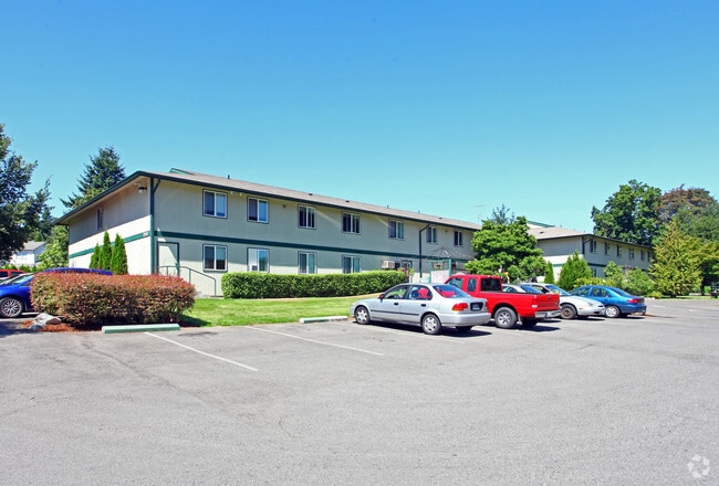

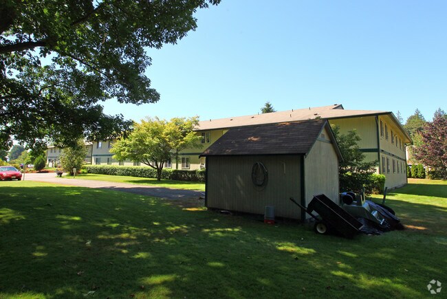
Property Detail
280 Sylvan Way
022401-3-064-2002
LOT A OF CITY OF BREMERTON SHORT PLAT NO. B-147, AS RECORDED UNDER AUDITORS FILE NO. 8510250076, RECORDS OF KITSAP COUNTY, WASHINGTON, BEING A PORTION OF THE NORTHEAST QUARTER OF THE SOUTHWEST QUARTER, SECTION 2, TOWNSHIP 24 NORTH, RANGE 1 EAST, W.M.
Retirementnursinghomecombined
Kitsap
R-10
Washington
B and X Area of moderate flood hazard, usually the area between the limits of the 100-year and 500-year floods.
a
0
1.92 AC
2026
East Bremerton
080101
Bremerton/Silverdale
26,752 SF
Bremerton-Silverdale-Port Orchard, WA
NEARBY LISTINGS FOR SALE OR LEASE
DEMOGRAPHICS near 280 Sylvan Way
1 mile
3 mile
5 mile
2025 Total Population
11,556
74,712
118,219
2030 Population
11,919
76,518
121,081
Pop Growth 2025-2030
+ 3.14%
+ 2.42%
+ 2.42%
Average Age
40
39
40
2025 Total Households
4,608
28,672
45,885
HH Growth 2025-2030
+ 3.36%
+ 2.71%
+ 2.65%
Median Household Inc
$78,348
$80,310
$86,562
Avg Household Size
2.40
2.40
2.40
2025 Avg HH Vehicles
2.00
2.00
2.00
Median Home Value
$430,828
$458,415
$480,464
Median Year Built
1979
1975
1980
Nearby Places
Map Layers
Map Styles
 Street
 Aerial
Layers
 Traffic
 Biking
Places
Listings with unknown addresses are not visible on the map
- Restaurants
- Banks
- Shops
- Fitness
- Groceries
PUBLIC TRANSPORTATION
AIRPORT
Seattle Paine Field International
Drive
Walk
Distance
Seattle Paine Field International
89 min
40.6 mi
Freight Ports
Port of Tacoma
Drive
Walk
Distance
Port of Tacoma
56 min
39.0 mi
Nearby Properties
Address
Land Use
TOTAL SIZE
Lot Size
Zoning
Address
Land Use
TOTAL SIZE
Lot Size
Zoning
329,553 SF
18.89 AC
UM
Address
Land Use
TOTAL SIZE
Lot Size
Zoning
0.13 AC
UH
Address
Land Use
TOTAL SIZE
Lot Size
Zoning
21,408 SF
8.26 AC
BVSAP
Address
Land Use
TOTAL SIZE
Lot Size
Zoning
134,724 SF
6.85 AC
GC
Address
Land Use
TOTAL SIZE
Lot Size
Zoning
138,877 SF
7.17 AC
R-10
Address
Land Use
TOTAL SIZE
Lot Size
Zoning
66,022 SF
8.28 AC
RR
Address
Land Use
TOTAL SIZE
Lot Size
Zoning
107,223 SF
12.76 AC
UM
Address
Land Use
TOTAL SIZE
Lot Size
Zoning
151,599 SF
5.44 AC
R-40
Address
Land Use
TOTAL SIZE
Lot Size
Zoning
132,092 SF
16.36 AC
UM
Address
Land Use
TOTAL SIZE
Lot Size
Zoning
2,672 SF
0.13 AC
UHUL
Address
Land Use
TOTAL SIZE
Lot Size
Zoning
214,450 SF
21.68 AC
R-40
Address
Land Use
TOTAL SIZE
Lot Size
Zoning
192,475 SF
16.26 AC
C
Address
Land Use
TOTAL SIZE
Lot Size
Zoning
1,716 SF
3.70 AC
UH
Address
Land Use
TOTAL SIZE
Lot Size
Zoning
Address
Land Use
TOTAL SIZE
Lot Size
Zoning
80,228 SF
7.03 AC
GC
Address
Land Use
TOTAL SIZE
Lot Size
Zoning
1,344 SF
5.47 AC
R-40
Address
Land Use
TOTAL SIZE
Lot Size
Zoning
79,615 SF
1.25 AC
DSAP
Address
Land Use
TOTAL SIZE
Lot Size
Zoning
75,390 SF
4.46 AC
R-18
Address
Land Use
TOTAL SIZE
Lot Size
Zoning
122,799 SF
4.48 AC
R-40
Address
Land Use
TOTAL SIZE
Lot Size
Zoning
63,213 SF
4.15 AC
R-10
Address
Land Use
TOTAL SIZE
Lot Size
Zoning
106,087 SF
9.40 AC
UM
Address
Land Use
TOTAL SIZE
Lot Size
Zoning
150,790 SF
26.33 AC
C
Address
Land Use
TOTAL SIZE
Lot Size
Zoning
58,376 SF
6.68 AC
R-18
Address
Land Use
TOTAL SIZE
Lot Size
Zoning
64,584 SF
4.92 AC
R-40
Address
Land Use
TOTAL SIZE
Lot Size
Zoning
68,079 SF
2.16 AC
BVSAP
Address
Land Use
TOTAL SIZE
Lot Size
Zoning
60,518 SF
2.62 AC
R-18
Address
Land Use
TOTAL SIZE
Lot Size
Zoning
55,412 SF
1.74 AC
R-18
Address
Land Use
TOTAL SIZE
Lot Size
Zoning
57,900 SF
3.90 AC
UH
Address
Land Use
TOTAL SIZE
Lot Size
Zoning
10.38 AC
Address
Land Use
TOTAL SIZE
Lot Size
Zoning
43,944 SF
2.64 AC
FC
The World's #1 Commercial Real Estate Marketplace
Connect with us
© 2026 CoStar Group
The information above has been obtained from sources believed reliable. While we do not doubt its accuracy we have not verified it and make no guarantee, warranty or representation about it. It is your responsibility to independently confirm its accuracy and completeness. Any projections, opinions, assumptions, or estimates used are for example only and do not represent the current or future performance of the property. The value of this transaction to you depends on tax and other factors which should be evaluated by your tax, financial, and legal advisors. You and your advisors should conduct a careful, independent investigation of the property to determine to your satisfaction the suitability of the property for your needs.