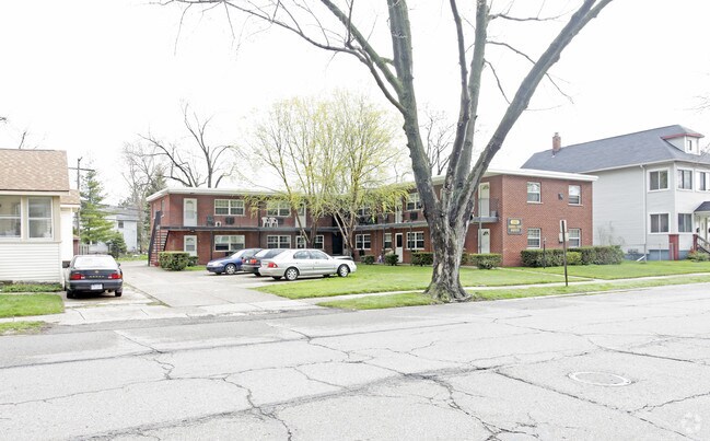
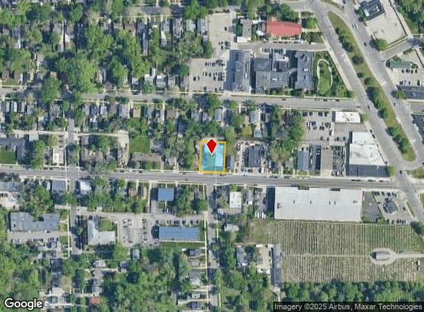
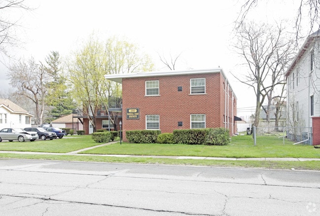
Property Record
280 W Marshall St, Ferndale, MI 48220

NEARBY LISTINGS FOR SALE OR LEASE
Property Detail
280 W Marshall St
Detroit-Warren-Dearborn, MI
Woodward Farms Sub
25-34-178-026
T1N, R11E, SEC 34 WOODWARD FARMS SUB LOTS 92 & 93
Multifamilydwelling
Oakland
X
Michigan
26163C0100E
92-93
2024
0.29 AC
2024
Ferndale
173400
Detroit
6,864 SF
DEMOGRAPHICS near 280 W Marshall St
1 Mile
3 Mile
5 Mile
2024 Total Population
14,971
147,456
403,360
2029 Population
14,822
145,969
400,322
Pop Growth 2024-2029
(1.00%)
(1.01%)
(0.75%)
Average Age
39
40
40
2024 Total Households
7,700
66,014
170,746
HH Growth 2024-2029
(0.95%)
(0.93%)
(0.73%)
Median Household Inc
$86,242
$60,213
$53,791
Avg Household Size
1.90
2.20
2.30
2024 Avg HH Vehicles
2.00
2.00
1.00
Median Home Value
$230,428
$173,436
$158,001
Median Year Built
1947
1951
1953
Nearby Places
Map Layers
Map Styles
 Street
 Aerial
- Restaurants
- Banks
- Shops
- Fitness
- Groceries
PUBLIC TRANSPORTATION
COMMUTER RAIL
Royal Oak Amtrak (Wolverine - Amtrak)
DRIVE
WALK
Distance
Royal Oak Amtrak (Wolverine - Amtrak)
7 min
2.9 mi
Troy Amtrak Station (Wolverine - Amtrak)
DRIVE
WALK
Distance
Troy Amtrak Station (Wolverine - Amtrak)
17 min
7.9 mi
AIRPORT
Windsor International
DRIVE
WALK
Distance
Windsor International
39 min
20.6 mi
Detroit Metro Wayne County
DRIVE
WALK
Distance
Detroit Metro Wayne County
44 min
30.2 mi
Freight Ports
Port of Toledo
DRIVE
WALK
Distance
Port of Toledo
89 min
71.1 mi
Nearby Properties
Address
Land Use
TOTAL SIZE
Lot Size
Zoning
Address
Land Use
TOTAL SIZE
Lot Size
Zoning
3,529,575 SF
84.46 AC
B4
Address
Land Use
TOTAL SIZE
Lot Size
Zoning
4.20 AC
REG BUS
Address
Land Use
TOTAL SIZE
Lot Size
Zoning
910,140 SF
47.78 AC
Address
Land Use
TOTAL SIZE
Lot Size
Zoning
0.81 AC
CBD
Address
Land Use
TOTAL SIZE
Lot Size
Zoning
10,734 SF
3.52 AC
SPEC REDEV
Address
Land Use
TOTAL SIZE
Lot Size
Zoning
649,140 SF
43.98 AC
Address
Land Use
TOTAL SIZE
Lot Size
Zoning
576,924 SF
31.35 AC
Address
Land Use
TOTAL SIZE
Lot Size
Zoning
306,345 SF
Address
Land Use
TOTAL SIZE
Lot Size
Zoning
576,924 SF
36.24 AC
Address
Land Use
TOTAL SIZE
Lot Size
Zoning
804 SF
1.50 AC
CBD
Address
Land Use
TOTAL SIZE
Lot Size
Zoning
1.46 AC
CBD
Address
Land Use
TOTAL SIZE
Lot Size
Zoning
339,780 SF
22.29 AC
RM-1
Address
Land Use
TOTAL SIZE
Lot Size
Zoning
150,703 SF
Address
Land Use
TOTAL SIZE
Lot Size
Zoning
259,959 SF
27.39 AC
MZ
Address
Land Use
TOTAL SIZE
Lot Size
Zoning
171,259 SF
1.26 AC
CBD
Address
Land Use
TOTAL SIZE
Lot Size
Zoning
199,592 SF
17.02 AC
B3
Address
Land Use
TOTAL SIZE
Lot Size
Zoning
303,615 SF
22.07 AC
MZ
Address
Land Use
TOTAL SIZE
Lot Size
Zoning
128,309 SF
1.74 AC
Address
Land Use
TOTAL SIZE
Lot Size
Zoning
0.61 AC
CBD
Address
Land Use
TOTAL SIZE
Lot Size
Zoning
1.07 AC
MIX USE 2
Address
Land Use
TOTAL SIZE
Lot Size
Zoning
46,894 SF
0.52 AC
CBD
Address
Land Use
TOTAL SIZE
Lot Size
Zoning
43,437 SF
3.30 AC
REG BUS
Address
Land Use
TOTAL SIZE
Lot Size
Zoning
123,844 SF
1.81 AC
R2
Address
Land Use
TOTAL SIZE
Lot Size
Zoning
156,250 SF
8.79 AC
B4
Address
Land Use
TOTAL SIZE
Lot Size
Zoning
137,583 SF
2.96 AC
BI
Address
Land Use
TOTAL SIZE
Lot Size
Zoning
73,701 SF
1.61 AC
PUD
Address
Land Use
TOTAL SIZE
Lot Size
Zoning
119,418 SF
13.81 AC
B4
Address
Land Use
TOTAL SIZE
Lot Size
Zoning
292,032 SF
20.25 AC
B4
Address
Land Use
TOTAL SIZE
Lot Size
Zoning
66,032 SF
3.61 AC
R-1
Address
Land Use
TOTAL SIZE
Lot Size
Zoning
180,056 SF
1.45 AC
II
The World's #1 Commercial Real Estate Marketplace
Connect with us
© 2025 CoStar Group
The information above has been obtained from sources believed reliable. While we do not doubt its accuracy we have not verified it and make no guarantee, warranty or representation about it. It is your responsibility to independently confirm its accuracy and completeness. Any projections, opinions, assumptions, or estimates used are for example only and do not represent the current or future performance of the property. The value of this transaction to you depends on tax and other factors which should be evaluated by your tax, financial, and legal advisors. You and your advisors should conduct a careful, independent investigation of the property to determine to your satisfaction the suitability of the property for your needs.