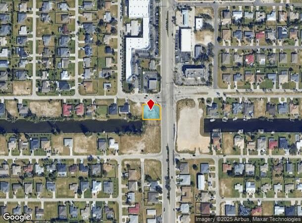
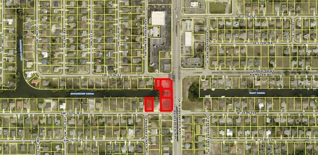
Property Record
2804 Santa Barbara Blvd N, Cape Coral, FL 33993
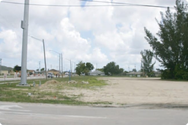
This Property Is For Sale
NEARBY LISTINGS FOR SALE OR LEASE
Property Detail
2804 Santa Barbara Blvd N
Cape Coral-Fort Myers, FL
Cape Coral
35-44-23-C2-01852.0030
CAPE CORAL UNIT 45 PT 1 BLK 1852 PB 21 PG 144 LOTS 3 THRU 5 LESS ROW INST #2007-208715
Commercialacreage
Lee
AE
Florida
12071C0401G
3-5
2024
0.30 AC
2025
Cape Coral
010206
Southwest Florida
DEMOGRAPHICS near 2804 Santa Barbara Blvd N
1 Mile
3 Mile
5 Mile
2024 Total Population
9,538
89,217
166,291
2029 Population
11,151
105,354
197,524
Pop Growth 2024-2029
+ 16.91%
+ 18.09%
+ 18.78%
Average Age
42
45
46
2024 Total Households
3,631
35,979
67,667
HH Growth 2024-2029
+ 16.47%
+ 17.67%
+ 18.36%
Median Household Inc
$68,964
$64,529
$67,156
Avg Household Size
2.60
2.40
2.40
2024 Avg HH Vehicles
2.00
2.00
2.00
Median Home Value
$265,467
$281,582
$299,914
Median Year Built
1994
1991
1993
Nearby Places
Map Layers
Map Styles
 Street
 Aerial
- Restaurants
- Banks
- Shops
- Fitness
- Groceries
PUBLIC TRANSPORTATION
AIRPORT
Southwest Florida International
DRIVE
WALK
Distance
Southwest Florida International
32 min
20.0 mi
Punta Gorda
DRIVE
WALK
Distance
Punta Gorda
42 min
28.4 mi
Freight Ports
Port Manatee
DRIVE
WALK
Distance
Port Manatee
122 min
100.0 mi
Nearby Properties
Address
Land Use
TOTAL SIZE
Lot Size
Zoning
Address
Land Use
TOTAL SIZE
Lot Size
Zoning
441,999 SF
19.96 AC
R-3
Address
Land Use
TOTAL SIZE
Lot Size
Zoning
476,419 SF
36.49 AC
C1
Address
Land Use
TOTAL SIZE
Lot Size
Zoning
263,280 SF
19.99 AC
RML
Address
Land Use
TOTAL SIZE
Lot Size
Zoning
340,032 SF
30.58 AC
R1-A
Address
Land Use
TOTAL SIZE
Lot Size
Zoning
300,366 SF
10.61 AC
RPUD
Address
Land Use
TOTAL SIZE
Lot Size
Zoning
96,539 SF
74.71 AC
INST
Address
Land Use
TOTAL SIZE
Lot Size
Zoning
4.89 AC
C-1
Address
Land Use
TOTAL SIZE
Lot Size
Zoning
282,066 SF
39.45 AC
INS
Address
Land Use
TOTAL SIZE
Lot Size
Zoning
239,211 SF
56.31 AC
INST
Address
Land Use
TOTAL SIZE
Lot Size
Zoning
278,679 SF
29.21 AC
C1-D
Address
Land Use
TOTAL SIZE
Lot Size
Zoning
101,204 SF
12.34 AC
P1-D
Address
Land Use
TOTAL SIZE
Lot Size
Zoning
139,978 SF
10.75 AC
C-1
Address
Land Use
TOTAL SIZE
Lot Size
Zoning
158,176 SF
20 AC
R-1
Address
Land Use
TOTAL SIZE
Lot Size
Zoning
142,773 SF
10.82 AC
C-1
Address
Land Use
TOTAL SIZE
Lot Size
Zoning
144,607 SF
20 AC
INS
Address
Land Use
TOTAL SIZE
Lot Size
Zoning
149,829 SF
5.70 AC
R-3
Address
Land Use
TOTAL SIZE
Lot Size
Zoning
54,248 SF
15.42 AC
C1-W
Address
Land Use
TOTAL SIZE
Lot Size
Zoning
101,999 SF
7.17 AC
P-1
Address
Land Use
TOTAL SIZE
Lot Size
Zoning
99,749 SF
11.49 AC
WSHP
Address
Land Use
TOTAL SIZE
Lot Size
Zoning
135,838 SF
40 AC
R-1
Address
Land Use
TOTAL SIZE
Lot Size
Zoning
153,651 SF
17.17 AC
R1-B
Address
Land Use
TOTAL SIZE
Lot Size
Zoning
147,599 SF
5.72 AC
RML
Address
Land Use
TOTAL SIZE
Lot Size
Zoning
28,560 SF
5.08 AC
P1-W
Address
Land Use
TOTAL SIZE
Lot Size
Zoning
113,239 SF
12.62 AC
R1-D
Address
Land Use
TOTAL SIZE
Lot Size
Zoning
227,560 SF
27.45 AC
C1-D
Address
Land Use
TOTAL SIZE
Lot Size
Zoning
47,660 SF
3.52 AC
C1-D
Address
Land Use
TOTAL SIZE
Lot Size
Zoning
95,942 SF
5.22 AC
C1-D
Address
Land Use
TOTAL SIZE
Lot Size
Zoning
93,636 SF
4.46 AC
C-1
Address
Land Use
TOTAL SIZE
Lot Size
Zoning
47,423 SF
13.86 AC
R1-D
Address
Land Use
TOTAL SIZE
Lot Size
Zoning
102,906 SF
2.95 AC
C
The World's #1 Commercial Real Estate Marketplace
Connect with us
© 2025 CoStar Group
The information above has been obtained from sources believed reliable. While we do not doubt its accuracy we have not verified it and make no guarantee, warranty or representation about it. It is your responsibility to independently confirm its accuracy and completeness. Any projections, opinions, assumptions, or estimates used are for example only and do not represent the current or future performance of the property. The value of this transaction to you depends on tax and other factors which should be evaluated by your tax, financial, and legal advisors. You and your advisors should conduct a careful, independent investigation of the property to determine to your satisfaction the suitability of the property for your needs.