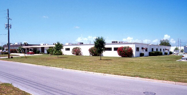
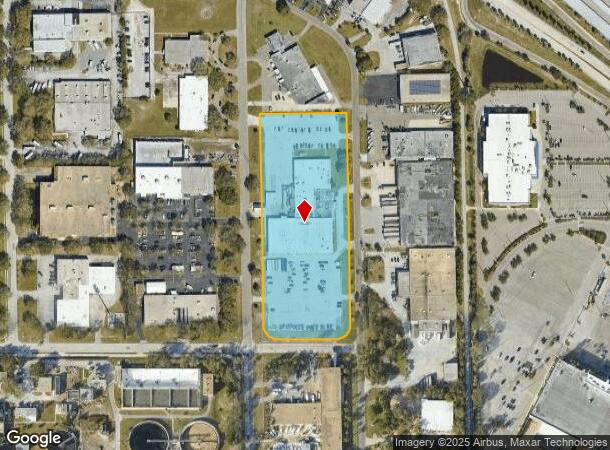
Property Record
2800 Anvil St N, Saint Petersburg, FL 33710
NEARBY LISTINGS FOR SALE OR LEASE
Property Detail
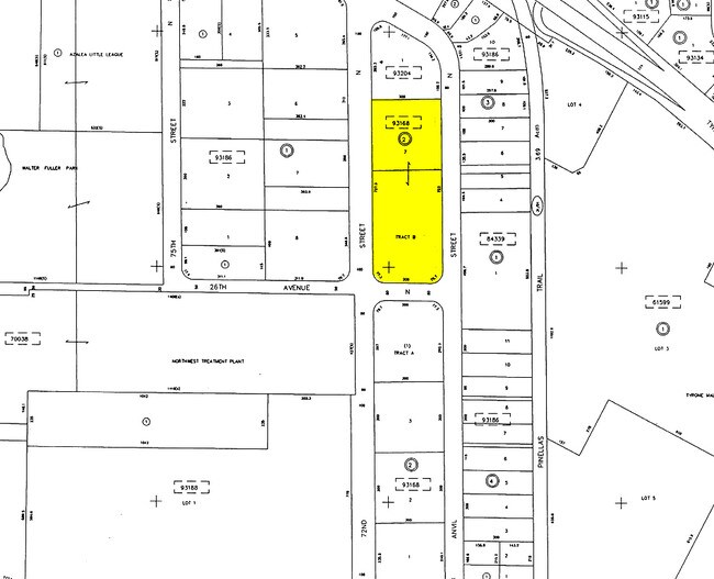
2800 Anvil St N
Tampa-St. Petersburg-Clearwater, FL
Tyrone Planned Industrial
07-31-16-93168-002-0070
TYRONE PLANNED INDUSTRIAL DISTRICT BLK 2, LOT 7 & TYRONE PLANNED INDUSTRIAL DISTRICT 2ND REP & ADD, TRACT B
Lightindustrial
Pinellas
X
Florida
12103C0211H
7
2024
5.36 AC
2025
South Pinellas
022402
Tampa/St Petersburg
51,258 SF
DEMOGRAPHICS near 2800 Anvil St N
1 Mile
3 Mile
5 Mile
2024 Total Population
10,717
94,509
244,599
2029 Population
10,660
94,821
246,275
Pop Growth 2024-2029
(0.53%)
+ 0.33%
+ 0.69%
Average Age
44
47
46
2024 Total Households
4,878
43,465
112,477
HH Growth 2024-2029
(0.76%)
+ 0.20%
+ 0.70%
Median Household Inc
$58,967
$60,342
$59,632
Avg Household Size
2.10
2.10
2.10
2024 Avg HH Vehicles
2.00
2.00
2.00
Median Home Value
$260,558
$264,397
$261,195
Median Year Built
1964
1966
1969
Nearby Places
Map Layers
Map Styles
 Street
 Aerial
- Restaurants
- Banks
- Shops
- Fitness
- Groceries
PUBLIC TRANSPORTATION
AIRPORT
St Pete-Clearwater International
DRIVE
WALK
Distance
St Pete-Clearwater International
29 min
13.0 mi
Tampa International
DRIVE
WALK
Distance
Tampa International
38 min
24.2 mi
Sarasota/Bradenton International
DRIVE
WALK
Distance
Sarasota/Bradenton International
57 min
36.2 mi
Freight Ports
Port Manatee
DRIVE
WALK
Distance
Port Manatee
43 min
28.7 mi
Nearby Properties
Address
Land Use
TOTAL SIZE
Lot Size
Zoning
Address
Land Use
TOTAL SIZE
Lot Size
Zoning
2,167,184 SF
297.75 AC
PSP
Address
Land Use
TOTAL SIZE
Lot Size
Zoning
459,848 SF
19.74 AC
R6
Address
Land Use
TOTAL SIZE
Lot Size
Zoning
738,882 SF
43.34 AC
Address
Land Use
TOTAL SIZE
Lot Size
Zoning
396,428 SF
19.76 AC
Address
Land Use
TOTAL SIZE
Lot Size
Zoning
436,119 SF
22.24 AC
Address
Land Use
TOTAL SIZE
Lot Size
Zoning
263,050 SF
34.20 AC
Address
Land Use
TOTAL SIZE
Lot Size
Zoning
142,529 SF
46.62 AC
Address
Land Use
TOTAL SIZE
Lot Size
Zoning
186,094 SF
11.96 AC
Address
Land Use
TOTAL SIZE
Lot Size
Zoning
181,708 SF
14.92 AC
R3
Address
Land Use
TOTAL SIZE
Lot Size
Zoning
127,237 SF
10.53 AC
Address
Land Use
TOTAL SIZE
Lot Size
Zoning
150,235 SF
17.90 AC
Address
Land Use
TOTAL SIZE
Lot Size
Zoning
195,863 SF
18.57 AC
Address
Land Use
TOTAL SIZE
Lot Size
Zoning
360,137 SF
37.64 AC
AE
Address
Land Use
TOTAL SIZE
Lot Size
Zoning
156,994 SF
29.11 AC
Address
Land Use
TOTAL SIZE
Lot Size
Zoning
142,281 SF
1.57 AC
Address
Land Use
TOTAL SIZE
Lot Size
Zoning
145,619 SF
1.68 AC
Address
Land Use
TOTAL SIZE
Lot Size
Zoning
144,334 SF
2.50 AC
Address
Land Use
TOTAL SIZE
Lot Size
Zoning
204,891 SF
18.20 AC
Address
Land Use
TOTAL SIZE
Lot Size
Zoning
116,358 SF
12.74 AC
Address
Land Use
TOTAL SIZE
Lot Size
Zoning
48,862 SF
3.72 AC
Address
Land Use
TOTAL SIZE
Lot Size
Zoning
220,805 SF
5.93 AC
Address
Land Use
TOTAL SIZE
Lot Size
Zoning
145,047 SF
12.03 AC
Address
Land Use
TOTAL SIZE
Lot Size
Zoning
151,391 SF
3.13 AC
Address
Land Use
TOTAL SIZE
Lot Size
Zoning
154,986 SF
11.08 AC
Address
Land Use
TOTAL SIZE
Lot Size
Zoning
46,749 SF
5.80 AC
Address
Land Use
TOTAL SIZE
Lot Size
Zoning
130,192 SF
2.40 AC
Address
Land Use
TOTAL SIZE
Lot Size
Zoning
151,421 SF
1.86 AC
Address
Land Use
TOTAL SIZE
Lot Size
Zoning
49,898 SF
77.25 AC
Address
Land Use
TOTAL SIZE
Lot Size
Zoning
119,580 SF
4.18 AC
Address
Land Use
TOTAL SIZE
Lot Size
Zoning
221,615 SF
16.33 AC
The World's #1 Commercial Real Estate Marketplace
Connect with us
© 2025 CoStar Group
The information above has been obtained from sources believed reliable. While we do not doubt its accuracy we have not verified it and make no guarantee, warranty or representation about it. It is your responsibility to independently confirm its accuracy and completeness. Any projections, opinions, assumptions, or estimates used are for example only and do not represent the current or future performance of the property. The value of this transaction to you depends on tax and other factors which should be evaluated by your tax, financial, and legal advisors. You and your advisors should conduct a careful, independent investigation of the property to determine to your satisfaction the suitability of the property for your needs.