Property Record
2800 Bailey Ave, Bronx, NY 10463
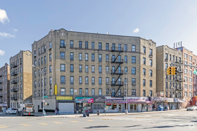

Property Detail
2800 Bailey Ave
03259-0006
Bronx
Apartment
New York
R6
6
B and X Area of moderate flood hazard, usually the area between the limits of the 100-year and 500-year floods.
0.50 AC
2024
Jerome Park
2025
Westchester/So Connecticut
027300
New York-Jersey City-White Plains, NY-NJ
107,920 SF
NEARBY LISTINGS FOR SALE OR LEASE
DEMOGRAPHICS near 2800 Bailey Ave
1 mile
3 mile
5 mile
2025 Total Population
177,551
955,835
1,986,536
2030 Population
177,772
950,037
1,976,332
Pop Growth 2025-2030
+ 0.12%
(0.61%)
(0.51%)
Average Age
40
39
39
2025 Total Households
64,497
340,048
725,324
HH Growth 2025-2030
+ 0.04%
(0.77%)
(0.52%)
Median Household Inc
$55,305
$50,163
$52,836
Avg Household Size
2.60
2.60
2.60
2025 Avg HH Vehicles
.00
.00
1.00
Median Home Value
$380,857
$523,444
$532,676
Median Year Built
1948
1949
1953
Nearby Places
Map Layers
Map Styles
 Street
 Aerial
Transit
 Traffic
 Biking
Places
Listings with unknown addresses are not visible on the map
- Restaurants
- Banks
- Shops
- Fitness
- Groceries
PUBLIC TRANSPORTATION
TRANSIT/SUBWAY
Marble Hill-225 Street (1 - New York MTA Subway (The Subway))
Drive
Walk
Distance
Marble Hill-225 Street (1 - New York MTA Subway (The Subway))
0 min
6 min
0.3 mi
231 Street (1 - New York MTA Subway (The Subway))
Drive
Walk
Distance
231 Street (1 - New York MTA Subway (The Subway))
1 min
8 min
0.5 mi
Kingsbridge Road (4 Line) (4 - New York MTA Subway (The Subway))
Drive
Walk
Distance
Kingsbridge Road (4 Line) (4 - New York MTA Subway (The Subway))
1 min
13 min
0.7 mi
215 Street (1 - New York MTA Subway (The Subway))
Drive
Walk
Distance
215 Street (1 - New York MTA Subway (The Subway))
2 min
14 min
0.7 mi
Kingsbridge Road (B,D Line) (B - New York MTA Subway (The Subway), D - New York MTA Subway (The Subway))
Drive
Walk
Distance
Kingsbridge Road (B,D Line) (B - New York MTA Subway (The Subway), D - New York MTA Subway (The Subway))
2 min
18 min
0.9 mi
COMMUTER RAIL
Marble Hill Station (Hudson Line - Metro-North Commuter Railroad Company (Metro-North))
Drive
Walk
Distance
Marble Hill Station (Hudson Line - Metro-North Commuter Railroad Company (Metro-North))
2 min
7 min
0.4 mi
University Heights Station (Hudson Line - Metro-North Commuter Railroad Company (Metro-North))
Drive
Walk
Distance
University Heights Station (Hudson Line - Metro-North Commuter Railroad Company (Metro-North))
2 min
1.1 mi
AIRPORT
LaGuardia
Drive
Walk
Distance
LaGuardia
20 min
11.1 mi
John F Kennedy International
Drive
Walk
Distance
John F Kennedy International
32 min
21.8 mi
Westchester County
Drive
Walk
Distance
Westchester County
33 min
22.3 mi
Freight Ports
NY - Red Hook Container Terminal
Drive
Walk
Distance
NY - Red Hook Container Terminal
33 min
19.3 mi
SALE & LEASE HISTORY
LISTING DATE
SALE/LEASE

Oct 31, 2022
For Lease
Dec 15, 2016
For Lease
Dec 13, 2017
For Lease
Apr 16, 2019
For Lease
Nearby Properties
Address
Land Use
TOTAL SIZE
Lot Size
Zoning
Address
Land Use
TOTAL SIZE
Lot Size
Zoning
3,693,539 SF
8.37 AC
R8
Address
Land Use
TOTAL SIZE
Lot Size
Zoning
1,299,700 SF
29.82 AC
R6
Address
Land Use
TOTAL SIZE
Lot Size
Zoning
1,743,584 SF
77.87 AC
R6
Address
Land Use
TOTAL SIZE
Lot Size
Zoning
111.37 AC
P1
Address
Land Use
TOTAL SIZE
Lot Size
Zoning
24.08 AC
B2-A
Address
Land Use
TOTAL SIZE
Lot Size
Zoning
1,651,267 SF
1.23 AC
R8
Address
Land Use
TOTAL SIZE
Lot Size
Zoning
Address
Land Use
TOTAL SIZE
Lot Size
Zoning
481,172 SF
205.58 AC
PARK
Address
Land Use
TOTAL SIZE
Lot Size
Zoning
895,256 SF
8.32 AC
R7-1
Address
Land Use
TOTAL SIZE
Lot Size
Zoning
1,237,424 SF
21.25 AC
R6
Address
Land Use
TOTAL SIZE
Lot Size
Zoning
204,200 SF
1.68 AC
R7-1
Address
Land Use
TOTAL SIZE
Lot Size
Zoning
42.68 AC
P1
Address
Land Use
TOTAL SIZE
Lot Size
Zoning
100,151 SF
22.13 AC
B2
Address
Land Use
TOTAL SIZE
Lot Size
Zoning
807,327 SF
0.60 AC
R8
Address
Land Use
TOTAL SIZE
Lot Size
Zoning
39 AC
P1
Address
Land Use
TOTAL SIZE
Lot Size
Zoning
390,750 SF
265 AC
PARK
Address
Land Use
TOTAL SIZE
Lot Size
Zoning
617,567 SF
3.19 AC
R7-1
Address
Land Use
TOTAL SIZE
Lot Size
Zoning
317,485 SF
1.57 AC
R8
Address
Land Use
TOTAL SIZE
Lot Size
Zoning
43.65 AC
PARK
Address
Land Use
TOTAL SIZE
Lot Size
Zoning
631,237 SF
30.93 AC
R5
Address
Land Use
TOTAL SIZE
Lot Size
Zoning
707,353 SF
29.34 AC
R6
Address
Land Use
TOTAL SIZE
Lot Size
Zoning
480,769 SF
1.21 AC
R8
Address
Land Use
TOTAL SIZE
Lot Size
Zoning
Address
Land Use
TOTAL SIZE
Lot Size
Zoning
1,392,950 SF
19.67 AC
M2-1
Address
Land Use
TOTAL SIZE
Lot Size
Zoning
15.76 AC
B2
Address
Land Use
TOTAL SIZE
Lot Size
Zoning
259.87 AC
PARK
Address
Land Use
TOTAL SIZE
Lot Size
Zoning
286,481 SF
0.62 AC
C6-2
Address
Land Use
TOTAL SIZE
Lot Size
Zoning
393,924 SF
4.50 AC
R7-2
Address
Land Use
TOTAL SIZE
Lot Size
Zoning
12.68 AC
P1
Address
Land Use
TOTAL SIZE
Lot Size
Zoning
4,928 SF
64.19 AC
PARK
The World's #1 Commercial Real Estate Marketplace
Connect with us
© 2026 CoStar Group
The information above has been obtained from sources believed reliable. While we do not doubt its accuracy we have not verified it and make no guarantee, warranty or representation about it. It is your responsibility to independently confirm its accuracy and completeness. Any projections, opinions, assumptions, or estimates used are for example only and do not represent the current or future performance of the property. The value of this transaction to you depends on tax and other factors which should be evaluated by your tax, financial, and legal advisors. You and your advisors should conduct a careful, independent investigation of the property to determine to your satisfaction the suitability of the property for your needs.