Property Record
2800 Bensley Commons Blvd, North Chesterfield, VA 23237
NEARBY LISTINGS FOR SALE OR LEASE
-
-
View all North Chesterfield listings for sale on LoopNet.com
Property Detail
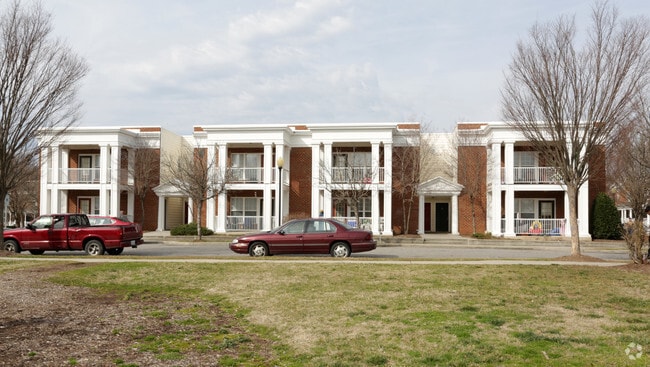
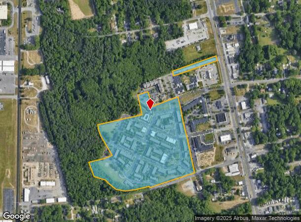
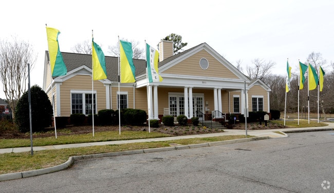
2800 Bensley Commons Blvd
790-67-90-80-600-000
W/L Jefferson Davis Hwy
Apartment
W/L JEFFERSON DAVIS HWY
X
Chesterfield
5101290100E
Virginia
0
23.68 AC
2025
Chesterfield County
100406
Richmond VA
138,860 SF
Richmond, VA
DEMOGRAPHICS near 2800 Bensley Commons Blvd
1 Mile
3 Mile
5 Mile
2024 Total Population
5,520
42,801
110,745
2029 Population
6,093
46,791
119,560
Pop Growth 2024-2029
+ 10.38%
+ 9.32%
+ 7.96%
Average Age
38
38
39
2024 Total Households
2,138
15,461
41,258
HH Growth 2024-2029
+ 10.48%
+ 9.46%
+ 8.04%
Median Household Inc
$38,139
$58,241
$58,635
Avg Household Size
2.50
2.70
2.60
2024 Avg HH Vehicles
2.00
2.00
2.00
Median Home Value
$198,814
$240,033
$239,777
Median Year Built
1977
1979
1981
Nearby Places
- Restaurants
- Banks
- Shops
- Fitness
- Groceries
PUBLIC TRANSPORTATION
COMMUTER RAIL
Richmond Main Street Amtrak Station (Northeast Regional - Amtrak)
DRIVE
WALK
Distance
Richmond Main Street Amtrak Station (Northeast Regional - Amtrak)
15 min
8.5 mi
AIRPORT
Richmond International
DRIVE
WALK
Distance
Richmond International
21 min
13.2 mi
Freight Ports
Virginia Port Authority - Richmond
DRIVE
WALK
Distance
Virginia Port Authority - Richmond
11 min
5.8 mi
Nearby Properties
Address
Land Use
TOTAL SIZE
Lot Size
Zoning
Address
Land Use
TOTAL SIZE
Lot Size
Zoning
100 SF
652.52 AC
A - AGRICU
Address
Land Use
TOTAL SIZE
Lot Size
Zoning
73,867 SF
54.52 AC
R7 - SINGL
Address
Land Use
TOTAL SIZE
Lot Size
Zoning
231,168 SF
57.31 AC
R7 - SINGL
Address
Land Use
TOTAL SIZE
Lot Size
Zoning
413.51 AC
I3 - HVY I
Address
Land Use
TOTAL SIZE
Lot Size
Zoning
437,024 SF
39.40 AC
I3 - HVY I
Address
Land Use
TOTAL SIZE
Lot Size
Zoning
406,110 SF
57.69 AC
I3 - HVY I
Address
Land Use
TOTAL SIZE
Lot Size
Zoning
462,732 SF
24.94 AC
M-2 HEAVY
Address
Land Use
TOTAL SIZE
Lot Size
Zoning
448,888 SF
35.33 AC
M-2 HEAVY
Address
Land Use
TOTAL SIZE
Lot Size
Zoning
306,439 SF
48.81 AC
M-2 HEAVY
Address
Land Use
TOTAL SIZE
Lot Size
Zoning
290,200 SF
50.99 AC
R7 - SINGL
Address
Land Use
TOTAL SIZE
Lot Size
Zoning
320,853 SF
33.68 AC
I3 - HVY I
Address
Land Use
TOTAL SIZE
Lot Size
Zoning
220,825 SF
55.17 AC
I3 - HVY I
Address
Land Use
TOTAL SIZE
Lot Size
Zoning
99,934 SF
27.15 AC
A - AGRICU
Address
Land Use
TOTAL SIZE
Lot Size
Zoning
55,952 SF
11.82 AC
C3 - COMMU
Address
Land Use
TOTAL SIZE
Lot Size
Zoning
406,490 SF
19.58 AC
I3 - HVY I
Address
Land Use
TOTAL SIZE
Lot Size
Zoning
406,490 SF
33.22 AC
I3 - HVY I
Address
Land Use
TOTAL SIZE
Lot Size
Zoning
67,060 SF
4.93 AC
C5 - GEN B
Address
Land Use
TOTAL SIZE
Lot Size
Zoning
23,586 SF
41.23 AC
I2 - GEN I
Address
Land Use
TOTAL SIZE
Lot Size
Zoning
100 SF
15.43 AC
RMF - RES,
Address
Land Use
TOTAL SIZE
Lot Size
Zoning
103,863 SF
20.55 AC
R7 - SINGL
Address
Land Use
TOTAL SIZE
Lot Size
Zoning
86,564 SF
22.62 AC
M-2 HEAVY
Address
Land Use
TOTAL SIZE
Lot Size
Zoning
318,611 SF
24.17 AC
I3 - HVY I
Address
Land Use
TOTAL SIZE
Lot Size
Zoning
115,080 SF
124 AC
M-2 HEAVY
Address
Land Use
TOTAL SIZE
Lot Size
Zoning
132,570 SF
12.60 AC
R-48 MULTI
Address
Land Use
TOTAL SIZE
Lot Size
Zoning
324,530 SF
31.47 AC
I3 - HVY I
Address
Land Use
TOTAL SIZE
Lot Size
Zoning
100 SF
10.85 AC
R7 - SINGL
Address
Land Use
TOTAL SIZE
Lot Size
Zoning
6.90 AC
R7 - SINGL
Address
Land Use
TOTAL SIZE
Lot Size
Zoning
5,412 SF
18.62 AC
C3 - COMMU
Address
Land Use
TOTAL SIZE
Lot Size
Zoning
100 SF
17.10 AC
RMF - RES,
The World's #1 Commercial Real Estate Marketplace
Connect with us
© 2025 CoStar Group
The information above has been obtained from sources believed reliable. While we do not doubt its accuracy we have not verified it and make no guarantee, warranty or representation about it. It is your responsibility to independently confirm its accuracy and completeness. Any projections, opinions, assumptions, or estimates used are for example only and do not represent the current or future performance of the property. The value of this transaction to you depends on tax and other factors which should be evaluated by your tax, financial, and legal advisors. You and your advisors should conduct a careful, independent investigation of the property to determine to your satisfaction the suitability of the property for your needs.